

419 datasets found for "infrastructure"
-
Federal
EnviroAtlas - MSPA connectivity with water as missing and 1-pixel edge width for the conterminous United States
U.S. Environmental Protection Agency —
This EnviroAtlas dataset categorizes land cover into structural elements (e.g. core, edge, connector, etc.). It depicts core areas of natural land cover, core... -
State
Facilities for Wildland Fire Protection
State of California —
This dataset is intended to provide a statewide depiction of CALFIRE and contract facilities for fire suppression. It includes state and local funded fire stations,... -
Federal
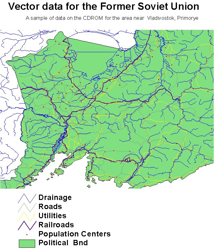
RLC Selected Infrastructure Data for the Former Soviet Union, 1993
National Aeronautics and Space Administration —
This data set consists of roads, drainage, railroads, utilities, and population center information in readily usable vector format for the land area of the Former... -
Federal
EnviroAtlas - National Inventory of Dams by 12-digit HUC for the Conterminous United States
U.S. Environmental Protection Agency —
This EnviroAtlas dataset is a summary of the National Dams Inventory data from 2009 survey. The file contains counts of inventoried dams by 12-digit hydrologic units... -
University
Cadastral PLSS Standardized Data - PLSSQuarterReference, NW - Version 1.1
Earth Data Analysis Center, University of New Mexico —
This feature class is part of the Cadastral National Spatial Data Infrastructure (NSDI) CADNSDI publication data set for rectangular and non-rectangular Public Land... -
State
California High Hazard Zones (Tier 1)
State of California —
On October 30, 2015 Governor Brown issued an emergency declaration requiring public agencies to identify areas of tree mortality that hold the greatest potential to... -
University
HSIP Hospitals in New Mexico
Earth Data Analysis Center, University of New Mexico —
Hospitals in New Mexico The term "hospital" ... means an institution which- (1) is primarily engaged in providing, by or under the supervision of physicians, to... -
Federal
EPA Facility Registry Service (FRS): ER_TSCA
U.S. Environmental Protection Agency —
This web feature service contains location and facility identification information from EPA's Facility Registry System (FRS) for the subset of facilities that link to... -
County
Baldwin Borough Storm Sewer Infrastructure
Allegheny County / City of Pittsburgh / Western PA Regional Data Center —
Data on where the Borough's storm lines, inlets/catch basins, manholes, and outfalls are located. -
State
Solar Techno-economic Exclusion
State of California —
The site suitability criteria included in the techno-economic land use screens are listed below. As this list is an update to previous cycles, tribal lands, prime... -
County
Allegheny County-Owned Bridges Centerlines
Allegheny County / City of Pittsburgh / Western PA Regional Data Center —
This dataset shows the bridges owned by Allegheny County. If viewing this description on the Western Pennsylvania Regional Data Center’s open data portal... -
Federal
EnviroAtlas - Durham, NC - Tree Cover Configuration and Connectivity, Water Background
U.S. Environmental Protection Agency —
This EnviroAtlas dataset categorizes forest land cover into structural elements (e.g. core, edge, connector, etc.). In this community, forest is only trees &... -
City
SPU DWW Aba Rem Mainlines
City of Seattle —
SPU DWW Mainlines is a Group Layer containing all Lifecycles, Ownerships, and other variations of Drainage and Wastewater Mainlines. The Connected Mainlines are... -
City
SPU DWW Mainlines (Probable Flow)
City of Seattle —
SPU DWW Mainlines is a Group Layer containing all Lifecycles, Ownerships, and other variations of Drainage and Wastewater Mainlines. The Connected Mainlines are... -
City
SPU DWW Underdrains & Rain Gardens
City of Seattle —
The DWW (Drainage and Waste Water) GSI (Green Stormwater Infrastructure) layer consists of line and polygon representations of the following features: Swales... -
City
SPU DWW Aba Rem Facility Footprints
City of Seattle —
The DWW (Drainage and Waste Water) GSI (Green Stormwater Infrastructure) layer consists of line and polygon representations of the following features: Swales... -
University
Cadastral PLSS Standardized Data - PLSSPoints (Clifton) - Version 1.1
Earth Data Analysis Center, University of New Mexico —
This feature class is part of the Cadastral National Spatial Data Infrastructure (NSDI) CADNSDI publication data set for rectangular and non-rectangular Public Land...
419 datasets found for "infrastructure"