
-
Federal
L01081: NOS Hydrographic Survey , 1903-12-31
National Oceanic and Atmospheric Administration, Department of Commerce —
The National Oceanic and Atmospheric Administration (NOAA) has the statutory mandate to collect hydrographic data in support of nautical chart compilation for safe... -
State
i07 WellReportPDFLinks
State of California —
This feature class represents an index of records from the California Department of Water Resources' (DWR) Online System for Well Completion Reports (OSWCR). This... -
Federal
L01100: NOS Hydrographic Survey , 1905-12-31
National Oceanic and Atmospheric Administration, Department of Commerce —
The National Oceanic and Atmospheric Administration (NOAA) has the statutory mandate to collect hydrographic data in support of nautical chart compilation for safe... -
State
MD iMAP: Maryland Water Quality - Tier II High Quality Waters 2012
State of Maryland —
This is a MD iMAP hosted service layer. Find more information at http://imap.maryland.gov. The intent of this dataset is for it to be used to produce maps and provide... -
Federal
LISTOS New Haven Ground Site Data
National Aeronautics and Space Administration —
LISTOS_Ground_NewHaven_Data is the Long Island Sound Tropospheric Ozone Study (LISTOS) ground site data collected at the New Haven ground site during the LISTOS field... -
State
Coastal Area Polygon
State of Connecticut —
Coastal Area & Boundary Polygon: The Coastal Area layer is a 1:24,000-scale, polygon feature-based layer that includes the land and waters that lie within the... -
Federal
NOAA's Hydrographic Surveys and Reports
National Oceanic and Atmospheric Administration, Department of Commerce —
The National Oceanic and Atmospheric Administration (NOAA) has the statutory mandate to collect hydrographic data to support the compilation of nautical charts and... -
Federal
Quality-controlled sea surface marine physical, meteorological and other in situ measurements from the NCEI Surface Underway Marine Database (NCEI-SUMD)
National Oceanic and Atmospheric Administration, Department of Commerce —
This collection contains global in-situ sea surface underway measurements from the NOAA NCEI Surface Underway Marine Database (NCEI-SUMD, formerly the NCEI... -
Impervious Surface 2021
District of Columbia —
The dataset contains basemap features that are typically classified as impervious surface, captured in 2021. Some examples of Impervious Surfaces include: Airport... -
Wetland Inventory
District of Columbia —
This data set represents the extent, approximate location and type of wetlands and deepwater habitats in the United States and its Territories. These data delineate... -
Washington DC Administrative Boundary
District of Columbia —
The District of Columbia jurisdiction and administrative boundary. The boundary was identified from public land records and digitized using a combination of sources... -
City
Inlets
City of Seattle —
This layer displays all the catch basins, catch basin grated tops, sandboxes, junction boxes, inlets and trash racks within the City of Seattle (and the former... -
Federal
Coastal Relief Models (CRMs)
National Oceanic and Atmospheric Administration, Department of Commerce —
Coastal Relief Models CRMs provide seamless topographic and bathymetric bare-earth elevation profiles of coastal regions for US states and territories. Extents span... -
Federal
Port Lions, Alaska 8/15 arc-second MHHW Coastal Digital Elevation Model
National Oceanic and Atmospheric Administration, Department of Commerce —
NOAA's National Centers for Environmental Information is building high-resolution digital elevation models (DEMs) to support individual coastal States as part of the... -
Federal
NIST/ASME Steam Properties Database - SRD 10
National Institute of Standards and Technology —
The NIST/ASME Steam Properties Database is based upon the International Association for the Properties of Water and Steam (IAPWS) 1995 formulation for general and... -
State
CA Congress Districts and Membership 2024-2026
State of California —
The 119th Congressional Districts dataset reflects boundaries from January 03, 2025 from the United States Census Bureau (USCB), and the attributes are updated every... -
Federal
F00473D: NOS Hydrographic Survey , San Diego Bay, California, 2001-04-13
National Oceanic and Atmospheric Administration, Department of Commerce —
The National Oceanic and Atmospheric Administration (NOAA) has the statutory mandate to collect hydrographic data in support of nautical chart compilation for safe... -
Federal
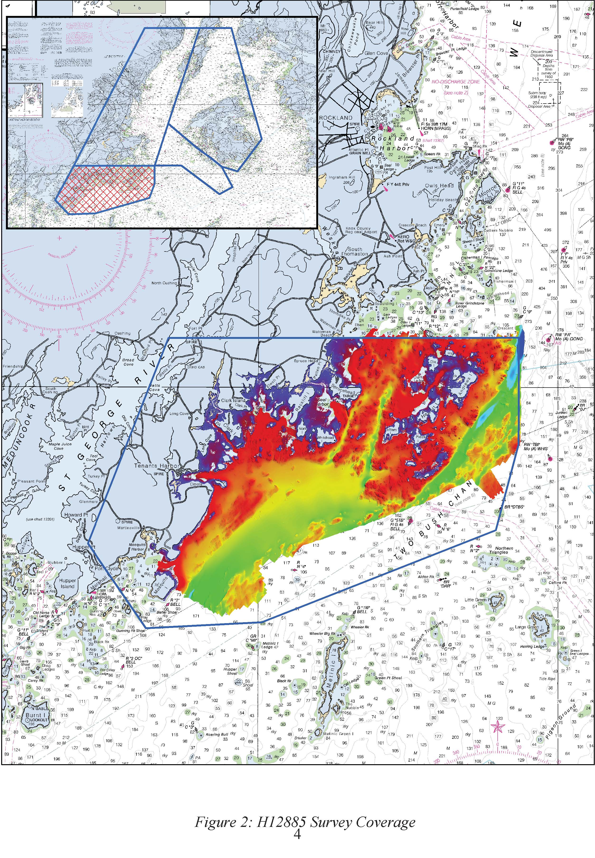
H12885: NOS Hydrographic Survey , 2016-09-29
National Oceanic and Atmospheric Administration, Department of Commerce —
The National Oceanic and Atmospheric Administration (NOAA) has the statutory mandate to collect hydrographic data in support of nautical chart compilation for safe... -
Federal
H07862: NOS Hydrographic Survey , 1950-12-31
National Oceanic and Atmospheric Administration, Department of Commerce —
The National Oceanic and Atmospheric Administration (NOAA) has the statutory mandate to collect hydrographic data in support of nautical chart compilation for safe... -
Federal
F00465: NOS Hydrographic Survey , No OPR Phone Conversation(F00465), 2000-05-31
National Oceanic and Atmospheric Administration, Department of Commerce —
The National Oceanic and Atmospheric Administration (NOAA) has the statutory mandate to collect hydrographic data in support of nautical chart compilation for safe...

Official websites use .gov
A
.gov website belongs to an official government
organization in the United States.
Secure .gov websites use HTTPS
A
lock (
) or https:// means you’ve safely connected to
the .gov website. Share sensitive information only on official,
secure websites.
.jpg)