

267 datasets found for "Reach File"
-
Federal
H13633: NOS Hydrographic Survey , 2024-05-22
National Oceanic and Atmospheric Administration, Department of Commerce —
The National Oceanic and Atmospheric Administration (NOAA) has the statutory mandate to collect hydrographic data in support of nautical chart compilation for safe... -
City
Louisville Metro KY - Homelessness Task Force Planning Table
Louisville Metro Government —
This data is no longer being actively updated. The dataset is deprecated and will be removed from the Portal within the next three months. If you have any questions,... -
Federal
Craters Of The Moon National Monument Small-Scale Base GIS Data
Department of the Interior —
This data set contains small-scale base GIS data layers compiled by the National Park Service Servicewide Inventory and Monitoring Program and Water Resources... -
Federal
LBA-ECO CD-06 Flux of CO2 from Amazon Mainstem Rivers, Tributaries, and Floodplains
National Aeronautics and Space Administration —
This data set provides estimates of monthly carbon dioxide (CO2) flux from the Amazon mainstem rivers, tributary stream networks, and their associated varzeas... -
State
Drainage Basin Lines
State of Connecticut —
See full Data Guide here. Drainage Basin Set: Connecticut Drainage Basins is 1:24,000-scale, polygon and line feature data that define natural drainage areas in... -
City
Louisville Metro KY - Property Maintenance Case Inspections (Verbose) Through June, 2019
Louisville Metro Government —
This data is no longer being actively updated. The dataset is deprecated and will be removed from the Portal within the next three months. For more up to date data,... -
Federal
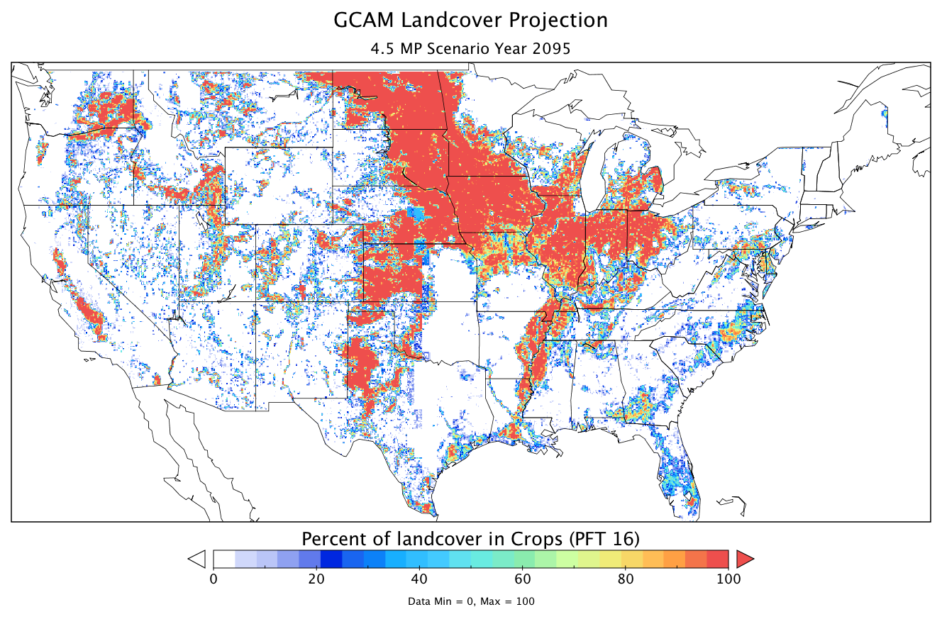
CMS: Land Cover Projections (5.6-km) from GCAM v3.1 for Conterminous USA, 2005-2095
National Aeronautics and Space Administration —
The data provided are annual land cover projections for years 2005 through 2095 generated by the Global Change Assessment Model (GCAM) Version 3.1. For the... -
Federal
R1: Aquatic Monitoring for Climate Change - Fish Assemblage and Habitat - Tabular and Relational Datasets
Department of the Interior —
This reference contains relational and tabular datasets for Aquatic Monitoring for Climate Change - Fish Assemblage and Habitat survey (PRIMR IDs: FF01RKTN00-035,... -
Federal
Lassen Volcanic National Park Small-Scale Base GIS Data
Department of the Interior —
This data set contains small-scale base GIS data layers compiled by the National Park Service Servicewide Inventory and Monitoring Program and Water Resources... -
Federal
NESE_betasdam Final data and code
U.S. Environmental Protection Agency —
Reach-scale flow classifications (ephemeral , intermittent, and perennial) based on direct hydrologic data and field (biological and geomorphological) and geospatial... -
State
Regional Drainage Basin Polygon
State of Connecticut —
See full Data Guide here. Regional Drainage Basin Set: Connecticut Regional Drainage Basins is 1:24,000-scale, polygon and line feature data that define Regional... -
State
Drainage Basin Polygon
State of Connecticut —
See full Data Guide here. Drainage Basin Set: Connecticut Drainage Basins is 1:24,000-scale, polygon and line feature data that define natural drainage areas in... -
Federal
Appalachian Basin Temperature-Depth Maps and Structured Data in support of Feasibility Study of Direct District Heating for the Cornell Campus Utilizing Deep Geothermal Energy
Department of Energy —
This dataset contains shapefiles and rasters that summarize the results of a stochastic analysis of temperatures at depth in the Appalachian Basin states of New York,... -
State
California County Boundaries and Identifiers with Coastal Buffers
State of California —
Note: The schema changed in February 2025 - please see below. We will post a roadmap of upcoming changes, but service URLs and schema are now stable. For deployment... -
Federal
Lake Roosevelt (Coulee Dam) National Recreation Area Small-Scale Base GIS Data
Department of the Interior —
This data set contains small-scale base GIS data layers compiled by the National Park Service Servicewide Inventory and Monitoring Program and Water Resources... -
Federal
Navajo National Monument Small-Scale Base GIS Data
Department of the Interior —
This data set contains small-scale base GIS data layers compiled by the National Park Service Servicewide Inventory and Monitoring Program and Water Resources... -
Federal
North Cascades National Park Small-Scale Base GIS Data
Department of the Interior —
This data set contains small-scale base GIS data layers compiled by the National Park Service Servicewide Inventory and Monitoring Program and Water Resources... -
University
Surface Water River Reach File
Earth Data Analysis Center, University of New Mexico —
This dataset contains the location for the surface water and river reaches for all New Mexico surface hydrography. It is in a vector digital data structure digitized... -
Federal
Mid-Columbia River NWRC and Central Washington NWRC: Invasive Plant Inventory and Early Detection Prioritization Tool (IPIEDT) - Area and Species Tables, 2019
Department of the Interior —
The IPIEDT is an Access Database file. The user responds to questions in a “yes/no/unknown” format or chooses from a list of states or conditions that best describe... -
Federal
NOAA/WDS Paleoclimatology - REACHES Reconstructed Temperature Index of China from 1368 to 1911
National Oceanic and Atmospheric Administration, Department of Commerce —
This archived Paleoclimatology Study is available from the NOAA National Centers for Environmental Information (NCEI), under the World Data Service (WDS) for...
267 datasets found for "Reach File"