
-
Federal
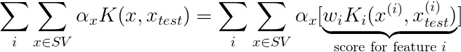
MKAD Anomaly Score Decomposition recent views
National Aeronautics and Space Administration —
not available -
Federal
Sentinel-6A MF Jason-CS L2 P4 Altimeter Low Resolution (LR) STC Reduced Ocean Surface Topography recent views
National Aeronautics and Space Administration —
Provides low resolution (LR) short time critical (STC; 36-hour latency) measurements of sea surface height anomaly (SSHA), Significant Wave Height (SWH), and Wind... -
Federal
HOMAGE Monthly Time series of global average steric height anomalies and ocean heat content estimates from gridded in-situ ocean observations version 01 recent views
National Aeronautics and Space Administration —
The [HOMAGE_STERIC_OHC_TIME_SERIES_v01] dataset contains monthly global mean ocean heat content (OHC) anomalies as well as thermosteric, halosteric and total steric... -
Federal
MODIS Terra Level 3 SST Thermal IR Annual 4km Nighttime V2019.0 NGDA recent views
National Aeronautics and Space Administration —
Day and night spatially gridded (L3) global NASA skin sea surface temperature (SST) products from the Moderate-resolution Imaging Spectroradiometer (MODIS) onboard... -
Federal
MODIS Terra Level 3 SST Thermal IR Daily 4km Nighttime V2019.0 NGDA recent views
National Aeronautics and Space Administration —
Day and night spatially gridded (L3) global NASA skin sea surface temperature (SST) products from the Moderate-resolution Imaging Spectroradiometer (MODIS) onboard... -
Federal
MODIS Terra Level 3 SST Thermal IR Daily 9km Nighttime V2019.0 NGDA recent views
National Aeronautics and Space Administration —
Day and night spatially gridded (L3) global NASA skin sea surface temperature (SST) products from the Moderate-resolution Imaging Spectroradiometer (MODIS) onboard... -
Federal
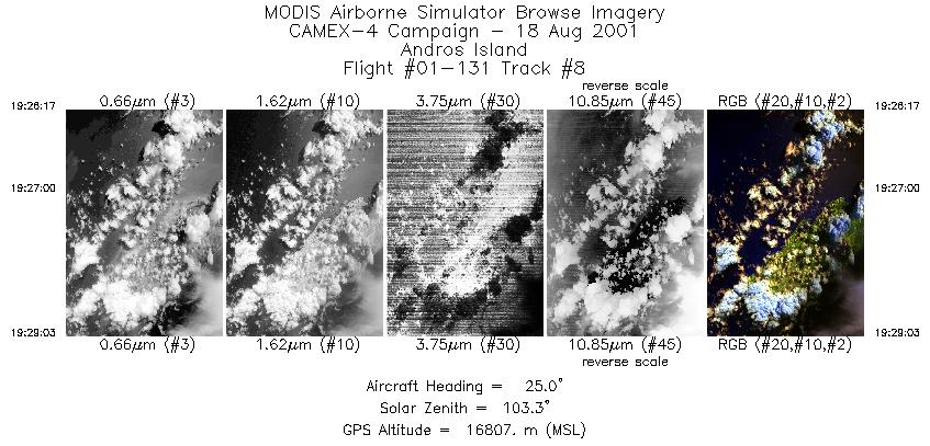
CAMEX-4 ER-2 MODIS AIRBORNE SIMULATOR (MAS) V1 recent views
National Aeronautics and Space Administration —
The MODIS Airborne Simulator (MAS) is an airborne scanning spectrometer that acquires high spatial resolution imagery of cloud and surface features from its vantage... -
Federal
Groundswell Spatial Population and Migration Projections at One-Eighth Degree According to SSPs and RCPs, 2010-2050 recent views
National Aeronautics and Space Administration —
The Groundswell Spatial Population and Migration Projections at One-Eighth Degree According to SSPs and RCPs, 2010-2050, data set provides a baseline population... -
Federal
MODIS Aqua Level 3 SST MID-IR 8 Day 9km Nighttime V2019.0 NGDA recent views
National Aeronautics and Space Administration —
Day and night spatially gridded (L3) global NASA skin sea surface temperature (SST) products from the Moderate-resolution Imaging Spectroradiometer (MODIS) onboard... -
Federal
MODIS Aqua Level 3 SST Thermal IR Daily 4km Daytime V2019.0 NGDA recent views
National Aeronautics and Space Administration —
Day and night spatially gridded (L3) global NASA skin sea surface temperature (SST) products from the Moderate-resolution Imaging Spectroradiometer (MODIS) onboard... -
Federal
West Florida South Buoy recent views
National Oceanic and Atmospheric Administration, Department of Commerce —
GCOOS 52North Sensor Observation Service This station provides the following variables: Air pressure, Air temperature, Relative humidity, Sea water practical... -
Federal
Gridded Population of the World, Version 3 (GPWv3): National Identifier Grid recent views
National Aeronautics and Space Administration —
The Gridded Population of the World, Version 3 (GPWv3): National Identifier Grid is derived from the land area grid to create a raster surface where pixels (cells)... -
Federal
Global High Resolution Daily Extreme Urban Heat Exposure (UHE-Daily), 1983-2016 recent views
National Aeronautics and Space Administration —
The Global High Resolution Daily Extreme Urban Heat Exposure (UHE-Daily), 1983-2016 data set contains a high-resolution, longitudinal global record of geolocated... -
Federal
Global Rural-Urban Mapping Project, Version 1 (GRUMPv1): Urban Extents Grid recent views
National Aeronautics and Space Administration —
The Global Rural-Urban Mapping Project, Version 1 (GRUMPv1): Urban Extents Grid distinguishes urban and rural areas based on a combination of population counts... -
Federal
LiDAR Surveys over Selected Forest Research Sites, Brazilian Amazon, 2008-2018 recent views
National Aeronautics and Space Administration —
This dataset provides the complete catalog of point cloud data collected during LiDAR surveys over selected forest research sites across the Amazon rainforest in... -
Federal
MASTER: FireSense, western US, October 2023 recent views
National Aeronautics and Space Administration —
This dataset includes Level 1B (L1B) data products from the MODIS/ASTER Airborne Simulator (MASTER) instrument. The spectral data were collected as part of the... -
Federal
H12414: NOS Hydrographic Survey , Long Island Sound, NY, 2012-08-22 recent views
National Oceanic and Atmospheric Administration, Department of Commerce —
The National Oceanic and Atmospheric Administration (NOAA) has the statutory mandate to collect hydrographic data in support of nautical chart compilation for safe... -
Federal
AIRS/Aqua L1B Near Real Time (NRT) AMSU (A1/A2) geolocated and calibrated brightness temperatures V005 (AIRABRAD_NRT) at GES DISC recent views
National Aeronautics and Space Administration —
The AMSU-A Level 1B Near Real Time (NRT) product (AIRABRAD_NRT_005) differs from the routine product (AIRABRAD_005) in 2 ways to meet the three hour latency... -
Federal
ABoVE: Vegetation Composition across Fire History Gradients on the Y-K Delta, Alaska recent views
National Aeronautics and Space Administration —
This dataset provides ecological field data that were collected during July 2017 and July 2018 from 43 plots spanning gradients of fire history in the upland tundra... -
Federal
RapidScat Level 2B Climate Ocean Wind Vectors in 12.5km Footprints Version 2.0 recent views
National Aeronautics and Space Administration —
This dataset contains the RapidScat Level 2B 12.5km Version 2.0 Climate quality ocean surface wind vectors. The Level 2B wind vectors are binned on a 12.5 km Wind...

Official websites use .gov
A
.gov website belongs to an official government
organization in the United States.
Secure .gov websites use HTTPS
A
lock (
) or https:// means you’ve safely connected to
the .gov website. Share sensitive information only on official,
secure websites.