
-
University
Dona Ana County Blocks, Total Population (2010)
Earth Data Analysis Center, University of New Mexico —
The once-a-decade decennial census was conducted in April 2010 by the U.S. Census Bureau. This count of every resident in the United States was mandated by Article I,... -
University
New Mexico, 2010 Census 5-Digit ZIP Code Tabulation Area (ZCTA5)
Earth Data Analysis Center, University of New Mexico —
The TIGER/Line Files are shapefiles and related database files (.dbf) that are an extract of selected geographic and cartographic information from the U.S. Census... -
Single Member District from 2013
District of Columbia —
Single Member District or SMD's. Single Member Districts (SMDs) were created pursuant to legislation approving the District of Columbia's Home Rule charter in 1973.... -
Federal
Gridded Population of the World, Version 3 (GPWv3): Population Count Grid, Future Estimates
National Aeronautics and Space Administration —
The Gridded Population of the World, Version 3 (GPWv3): Population Count Grid, Future Estimates consists of estimates of human population for the years 2005, 2010,... -
University
2000 Census 5-Digit ZIP Code Tabulation Areas (ZCTAs) for Santa Fe County, New Mexico, 2006se TIGER
Earth Data Analysis Center, University of New Mexico —
The 2006 Second Edition TIGER/Line files are an extract of selected geographic and cartographic information from the Census TIGER database. The geographic coverage... -
University
INCOME Family Income in 1999 SDs 2000
Earth Data Analysis Center, University of New Mexico —
The New Mexico 2000 Unified School Districts layer was derived from the TIGER Line files from the US Census Bureau. The districts are clipped to the state boundaries,... -
University
AGE Persons by Broad Age Groups and Median Age NMSD 2000
Earth Data Analysis Center, University of New Mexico —
The 2006 Second Edition TIGER/Line files are an extract of selected geographic and cartographic information from the Census TIGER database. The geographic coverage... -
University
2000 Census Public Use Microdata Area (PUMA) 5% for Los Alamos County, New Mexico, 2006se TIGER
Earth Data Analysis Center, University of New Mexico —
The 2006 Second Edition TIGER/Line files are an extract of selected geographic and cartographic information from the Census TIGER database. The geographic coverage... -
Federal
Social Vulnerability Index (SoVI) for Rhode Island based on 2000 Census Block Groups
National Oceanic and Atmospheric Administration, Department of Commerce —
This data depicts the social vulnerability of Rhode Island census block groups to environmental hazards. Data were culled primarily from the 2000 Decennial Census. -
University
2000 Census Voting Precincts for Lea County, New Mexico, 2006se TIGER
Earth Data Analysis Center, University of New Mexico —
The 2006 Second Edition TIGER/Line files are an extract of selected geographic and cartographic information from the Census TIGER database. The geographic coverage... -
University
RACE ETHNICITY Persons by Race NMSD 2000
Earth Data Analysis Center, University of New Mexico —
The 2006 Second Edition TIGER/Line files are an extract of selected geographic and cartographic information from the Census TIGER database. The geographic coverage... -
Federal
Gridded Population of the World, Version 4 (GPWv4): Population Density Adjusted to Match 2015 Revision UN WPP Country Totals, Revision 11
National Aeronautics and Space Administration —
The Gridded Population of the World, Version 4 (GPWv4): Population Density Adjusted to Match 2015 Revision of UN WPP Country Totals, Revision 11 consists of estimates... -
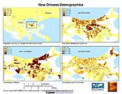
Federal
U.S. Population Grids (Summary File 1), 2000: New Orleans Metropolitan Statistical Area, Alpha Version
National Aeronautics and Space Administration —
U.S. Population Grids (Summary File 1), 2000: New Orleans Metropolitan Statistical Area, Alpha Version contains an ARC/INFO Workspace with grids of demographic data... -
University
San Miguel County 2000 Census Block Groups
Earth Data Analysis Center, University of New Mexico —
TIGER, TIGER/Line, and Census TIGER are registered trademarks of the Bureau of the Census. The Redistricting Census 2000 TIGER/Line files are an extract of selected... -
University
Bernalillo County TIGER 2000 Roads and Nodes
Earth Data Analysis Center, University of New Mexico —
TIGER, TIGER/Line, and Census TIGER are registered trademarks of the Bureau of the Census. The Redistricting Census 2000 TIGER/Line files are an extract of selected... -
University
EDUCATION Attainment of Persons by Detailed Category NMSD 2000
Earth Data Analysis Center, University of New Mexico —
The 2006 Second Edition TIGER/Line files are an extract of selected geographic and cartographic information from the Census TIGER database. The geographic coverage... -
University
2000 Census Public Use Microdata Area (PUMA) 5% for Colfax County, New Mexico, 2006se TIGER
Earth Data Analysis Center, University of New Mexico —
The 2006 Second Edition TIGER/Line files are an extract of selected geographic and cartographic information from the Census TIGER database. The geographic coverage... -
University
Sandoval County Blocks, Housing Occupancy Status (2010)
Earth Data Analysis Center, University of New Mexico —
The once-a-decade decennial census was conducted in April 2010 by the U.S. Census Bureau. This count of every resident in the United States was mandated by Article I,... -
University
HOME VALUE Percent Specified Owner Occ Units by Value NMHD 2000
Earth Data Analysis Center, University of New Mexico —
The 2006 Second Edition TIGER/Line files are an extract of selected geographic and cartographic information from the Census TIGER database. The geographic coverage... -
University
Eddy County Blocks, Housing Occupancy Status (2010)
Earth Data Analysis Center, University of New Mexico —
The once-a-decade decennial census was conducted in April 2010 by the U.S. Census Bureau. This count of every resident in the United States was mandated by Article I,...

Official websites use .gov
A
.gov website belongs to an official government
organization in the United States.
Secure .gov websites use HTTPS
A
lock (
) or https:// means you’ve safely connected to
the .gov website. Share sensitive information only on official,
secure websites.