
-
Federal
Soil Moisture Gravimetric Data (FIFE)
National Aeronautics and Space Administration —
The gravimetrical soil moisture data were collected from many stations spread over the FIFE study area. These data were collected to characterize the spatial and... -
Federal
Soil Moisture Transect Data (FIFE)
National Aeronautics and Space Administration —
The aim of the FIFE soil moisture transect work was to characterize spatial and temporal patterns of soil moisture along selected transects at the FIFE study area.... -
Federal
Soil Hydraulic Conductivity Data (FIFE)
National Aeronautics and Space Administration —
The Soil Hydraulic Conductivity Data Set contains soil hydraulic conductivity, matric flux potential, and soil depth data collected during the 1989 FIFE soil... -
Federal
Site Averaged Gravimetric Soil Moisture: 1989 (Betts)
National Aeronautics and Space Administration —
The Site Averaged Gravimetric Soil Moisture Data: 1987 - 1989 (Betts) Data Set contains the site averaged product data collected during the 1987-1989 FIFE experiment.... -
Federal
Site Averaged Gravimetric Soil Moisture: 1988 (Betts)
National Aeronautics and Space Administration —
The Site Averaged Gravimetric Soil Moisture Data: 1988 (Betts) Data Set contains the site averaged product data collected during the 1987-1989 FIFE experiment.... -
Federal
NRT AMSR2 Unified L2B Half-Orbit 25 km EASE-Grid Surface Soil Moisture Beta V2
National Aeronautics and Space Administration —
The Advanced Microwave Scanning Radiometer 2 (AMSR2) instrument on the Global Change Observation Mission - Water 1 (GCOM-W1) provides global passive microwave... -
Federal
ECOSTRESS Tiled Evaporative Stress Index PT-JPL Instantaneous L4 Global 70 m V002
National Aeronautics and Space Administration —
The ECOsystem Spaceborne Thermal Radiometer Experiment on Space Station (ECOSTRESS) mission measures the temperature of plants to better understand how much water... -
Federal
ECOSTRESS Gridded Evaporative Stress Index PT-JPL Instantaneous L4 Global 70 m V002
National Aeronautics and Space Administration —
The ECOsystem Spaceborne Thermal Radiometer Experiment on Space Station (ECOSTRESS) mission measures the temperature of plants to better understand how much water... -
Federal
ECOSTRESS Tiled Surface Energy Balance Instantaneous L3 Global 70 m V002
National Aeronautics and Space Administration —
The ECOsystem Spaceborne Thermal Radiometer Experiment on Space Station (ECOSTRESS) mission measures the temperature of plants to better understand how much water... -
Federal
ESMR/Nimbus-6 Images of Brightness Temperature on 70 mm Film V001 (ESMRN6IM) at GES DISC
National Aeronautics and Space Administration —
ESMRN6IM is the Nimbus-6 Electrically Scanning Microwave Radiometer (ESMR) data product containing daily brightness temperature images from 70-mm photofacsimile film... -
Federal
CMS: Fire Weather Indices for Interior Alaska, 2001-2010
National Aeronautics and Space Administration —
This dataset provides daily fire weather indices for interior Alaska during the active fire seasons from 2001 to 2010. Data are gridded at 60-m resolution. The active... -
Federal
BOREAS TF-04 CO2 and CH4 Soil Profile Data from the SSA
National Aeronautics and Space Administration —
The BOREAS TF-04 team measured distributions of carbon dioxide (CO2) and methane (CH4) concentrations for the upper 5 meters of soil and unsaturated zone at the... -
Federal
BOREAS HYD-06 Ground Gravimetric Soil Moisture Data
National Aeronautics and Space Administration —
This data set contains percent soil moisture ground measurements. These data were collected on the ground along the various flight lines flown in the Southern and... -
Federal
Soil CO2 Flux Data (FIFE)
National Aeronautics and Space Administration —
In the Soil Carbon Dioxide Flux study, a prototype gas exchange system and sensor were used to determine the soil surface flux of CO2 and associated parameters at the... -
Federal
Soil Moisture Data: Peck (FIFE)
National Aeronautics and Space Administration —
Water content measurements by gravimetric methods involve weighing a wet sample, removing the water via drying in an oven, and reweighing the sample to determine the... -
Federal
ESMR/Nimbus-5 Level 1 Calibrated Brightness Temperature V001 (ESMRN5L1) at GES DISC
National Aeronautics and Space Administration —
ESMRN5L1 is the Nimbus-5 Electrically Scanning Microwave Radiometer (ESMR) Level 1 Calibrated Brightness Temperature product and contains calibrated radiances... -
Federal
Arctic Vegetation Plots ATLAS Project North Slope and Seward Peninsula, AK, 1998-2000
National Aeronautics and Space Administration —
This data set provides environmental, soil, and vegetation data collected from study sites on the North Slope and Seward Peninsula of Alaska during the Arctic... -
Federal
ISLSCP II ECMWF Near-Surface Meteorology Parameters
National Aeronautics and Space Administration —
This data set for the ISLSCP Initiative II data collection provides meteorology data with fixed, monthly, monthly-6-hourly, 6-hourly, and 3-hourly temporal... -
Federal
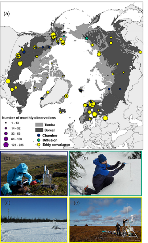
The ABCflux Database: Arctic-Boreal CO2 Flux and Site Environmental Data, 1989-2020
National Aeronautics and Space Administration —
This Arctic-Boreal CO2 fluxes (ABCflux) dataset contains monthly aggregates of terrestrial net ecosystem CO2 exchange and its derived partitioned component fluxes:... -
Federal
AirMOSS: L1 S-0 Polarimetric Data from AirMOSS P-band SAR, Harvard Forest, 2012-2015
National Aeronautics and Space Administration —
This data set provides level 1 (L1) polarimetric radar backscattering coefficient (sigma-0), multilook complex, polarimetrically calibrated, and georeferenced data...

Official websites use .gov
A
.gov website belongs to an official government
organization in the United States.
Secure .gov websites use HTTPS
A
lock (
) or https:// means you’ve safely connected to
the .gov website. Share sensitive information only on official,
secure websites.