
-
Federal
SAFARI 2000 C-130 Aerosol and Meteorological Data, Dry Season 2000
National Aeronautics and Space Administration —
The Met Office C-130 research aircraft was based at Windhoek, Namibia between September 5-16, 2000, where it conducted a series of flights over Namibia as part of the... -
Federal
SAFARI 2000 Emissions Estimates, MODIS Burned Area Product, Dry Season 2000
National Aeronautics and Space Administration —
The recently generated MODIS burned area product over southern Africa for the month of September 2000 was used to calculate regional biomass burning emissions from... -
Federal
Water Quality and Spectral Reflectance, Peace-Athabasca Delta, Canada, 2010-2011
National Aeronautics and Space Administration —
The Peace-Athabasca Delta (PAD) is a hydrologically complex and ecologically diverse freshwater delta formed by the confluence of the Peace, Athabasca, and Birch... -
Federal
Wind Profile Data: LIDAR - NOAA (FIFE)
National Aeronautics and Space Administration —
The aim of this wind profile study was to derive wind profiles and momentum fluxes from the National Oceanic and Atmospheric Administration (NOAA)/Wave Propagation... -
Federal
Tree Canopy Cover for the Circumpolar Taiga-Tundra Ecotone: 2000-2005
National Aeronautics and Space Administration —
This data set provides a map of selected areas with defined tree canopy cover over the circumpolar taiga-tundra ecotone (TTE). Canopy cover was derived from the... -
Federal
Timeseries of Arctic-Boreal Lake Area Derived from CubeSat Imagery, 2017
National Aeronautics and Space Administration —
This dataset provides near-daily lake area timeseries for 85,358 lakes across four study areas in Northern Canada and Alaska, USA, between May 1 and October 1, 2017.... -
Federal
PhenoCam Dataset v3.0: Vegetation Phenology from Digital Camera Imagery, 2000-2023
National Aeronautics and Space Administration —
This dataset provides vegetation phenological observations for 738 sites across diverse ecosystems of the world (mostly North America) from 2000 to 2023. The... -
Federal
Pre-LBA Anglo-Brazilian Amazonian Climate Observation Study (ABRACOS) Data
National Aeronautics and Space Administration —
The data set presents the principal data from the Anglo-BRazilian Amazonian Climate Observation Study (ABRACOS) (Gash et al, 1996) and provides quality controlled... -
Federal
Soil Organic Carbon and Wetland Intrinsic Potential, Hoh River Watershed, WA, 2012-13
National Aeronautics and Space Administration —
This dataset contains estimates of soil organic carbon stocks and wetland intrinsic potential (WIP) across the Hoh River Watershed in the Olympic Peninsula, WA, USA... -
Federal
Soil Bulk Density Data (FIFE)
National Aeronautics and Space Administration —
Soil bulk density is defined as the ratio of the mass of dry solids to the bulk volume of the soil occupied by those dry solids. Bulk density of the soil is an... -
Federal
SNF Forest Understory Cover Data (Table)
National Aeronautics and Space Administration —
The purpose of the SNF study was to improve our understanding of the relationship between remotely sensed observations and important biophysical parameters in the... -
Federal
Site Averaged AMS Data: 1989 (Betts)
National Aeronautics and Space Administration —
The Site Averaged AMS Data: 1989 (Betts) Data Set contains the site averaged product of the Portable Automatic Meteorological Station (AMS) data acquired during the... -
Federal
SNF Forest Understory Cover Data
National Aeronautics and Space Administration —
The purpose of the SNF study was to improve our understanding of the relationship between remotely sensed observations and important biophysical parameters in the... -
Federal
Site Averaged Gravimetric Soil Moisture: 1987 (Betts)
National Aeronautics and Space Administration —
The Site Averaged Gravimetric Soil Moisture Data: 1987 (Betts) Data Set contains the site averaged product data collected during the 1987-1989 FIFE experiment.... -
Federal
NPP Tropical Forest: Luquillo, Puerto Rico, 1946-1994, R1
National Aeronautics and Space Administration —
This data set contains ten ASCII files (.txt format), one NPP file for each of the nine different montane tropical rainforest sites within the Luquillo Experimental... -
Federal
NPP Tropical Forest: Cinnamon Bay, U.S. Virgin Islands, 1982-1993, R1
National Aeronautics and Space Administration —
This data set contains three ASCII files (.txt format). One data file contains above-ground biomass, litter, litterfall, herbivory, biomass change, and above-ground... -
Federal
Forest Inventories at Burned and Unburned Tropical Forest Sites, Acre, Brazil, 2014
National Aeronautics and Space Administration —
This dataset provides measurements for diameter at breast height (DBH) and species identification of trees for inventories taken at five tropical forest sites in Acre... -
Federal
Global Soil Types, 0.5-Degree Grid (Modified Zobler)
National Aeronautics and Space Administration —
A global data set of soil types is available at 0.5-degree latitude by 0.5-degree longitude resolution. There are 106 soil units, based on Zobler?s (1986) assessment... -
Federal
Gridded GEDI Vegetation Structure Metrics and Biomass Density at Multiple Resolutions
National Aeronautics and Space Administration —
This dataset consists of near-global, analysis-ready, multi-resolution gridded vegetation structure metrics derived from NASA Global Ecosystem Dynamics Investigation... -
Federal
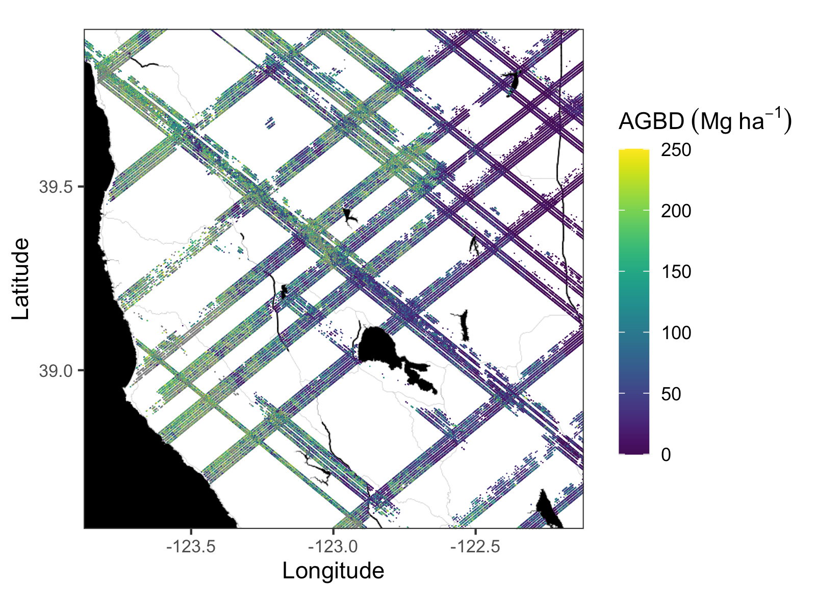
GEDI L4A Footprint Level Aboveground Biomass Density, Golden Weeks, Version 1
National Aeronautics and Space Administration —
This dataset contains Global Ecosystem Dynamics Investigation (GEDI) Level 4A (L4A) predictions of the aboveground biomass density (AGBD; in Mg/ha) and estimates of...

Official websites use .gov
A
.gov website belongs to an official government
organization in the United States.
Secure .gov websites use HTTPS
A
lock (
) or https:// means you’ve safely connected to
the .gov website. Share sensitive information only on official,
secure websites.