
-
Federal
Gridded CO2 and CH4 Flux Estimates for pan-Arctic and Boreal Regions, 2003-2015
National Aeronautics and Space Administration —
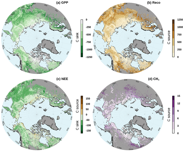
This dataset provides gridded estimates of gross primary productivity (GPP), ecosystem respiration (Reco), net ecosystem CO2 exchange (NEE = Reco - GPP), and methane... -
Federal
Lund-Potsdam-Jena Wetland Hydrology and Methane DGV Model (LPJ-WHyMe v1.3.1)
National Aeronautics and Space Administration —
This model product provides the Fortran 77 source code for the Lund-Potsdam-Jena (LPJ) Wetland Hydrology and Methane Dynamic Global Vegetation Model (LPJ-WHyMe... -
Federal
Carbon Pools across CONUS using the MaxEnt Model, 2005, 2010, 2015, 2016, and 2017
National Aeronautics and Space Administration —
This dataset provides annual estimates of six carbon pools, including forest aboveground live biomass, belowground biomass, aboveground dead biomass, belowground dead... -
Federal
BOREAS TE-20 Soils Data over the NSA-MSA and Tower Sites in Raster Format
National Aeronautics and Space Administration —
This data set was gridded from vector layers of soil maps that were received from Dr. Hugo Veldhuis, who did the original mapping in the field during 1994. The vector... -
Federal
Global Gridded Surfaces of Selected Soil Characteristics (IGBP-DIS)
National Aeronautics and Space Administration —
The Global Gridded Surfaces of Selected Soil Characteristics (IGBP-DIS) data set contains 7 data surfaces: soil-carbon density, total nitrogen density, field... -
Federal
SAFARI 2000 Meteorological Tower Measurements, Kruger National Park, 2000-2002
National Aeronautics and Space Administration —
An eddy covariance system mounted on a tower near the Skukuza Camp in Kruger National Park, South Africa, has been operating continuously since early 2000.... -
Federal
Arctic Vegetation Plots at Atqasuk, Alaska, 1975, 2000, and 2010
National Aeronautics and Space Administration —
This data set provides vegetation species abundance data collected in 1975 from 60 sites on the Arctic Coastal Plain near Atqasuk, Alaska, as well as environmental... -
Federal
Bowen Ratio Surface Flux: USGS (FIFE)
National Aeronautics and Space Administration —
The Bowen Ratio Surface Flux Observations (USGS) Data Set contains surface flux and micrometeorological collected from one location within the Northwest quadrant of... -
Federal
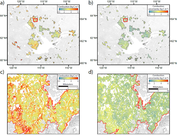
ABoVE: Wildfire Carbon Emissions and Burned Plot Characteristics, NWT, CA, 2014-2016
National Aeronautics and Space Administration —
This dataset provides estimates of wildfire carbon emissions and uncertainties at 30-m resolution, and measurements collected at burned and unburned field plots from... -
Federal
BOREAS RSS-17 Stem, Soil, and Air Temperature Data
National Aeronautics and Space Administration —
The BOREAS RSS-17 team collected several data sets in support of its research in monitoring and analyzing environmental and phenological states using radar data. This... -
Federal
Soil Moisture Profiles and Temperature Data from SoilSCAPE Sites, USA
National Aeronautics and Space Administration —
This data set contains in-situ soil moisture profile and soil temperature data collected at 20-minute intervals at SoilSCAPE (Soil moisture Sensing Controller and... -
Federal
CARVE: L1 In-situ Carbon and CH4 Flux and Meteorology at EC Towers, Alaska, 2011-2015
National Aeronautics and Space Administration —
This data set provides ground in situ flux and meteorological science data from fixed instruments at three eddy covariance tower sites located in the Alaskan Arctic... -
Federal
Bowen Ratio Surface Flux: GSFC (FIFE)
National Aeronautics and Space Administration —
The Bowen Ratio Surface Flux Observations (GSFC) Data Set contains data collected using the Bowen Ratio Techniques. The major data collection effort was conducted in... -
Federal
BOREAS Follow-On FLX-01 NSA-OBS Tower Flux, Meteorological, and Soil Temp. Data
National Aeronautics and Space Administration —
The BOREAS Follow-On FLX-01 team collected tower flux, surface meteorological, and soil temperature data at the BOREAS NSA-OBS site continuously from March 1994... -
Federal
ABoVE: CO2 and CH4 Fluxes and Meteorology at Flux Tower Sites, Alaska, 2015-2017
National Aeronautics and Space Administration —
This dataset provides CO2 and CH4 fluxes and meteorological parameters from five eddy covariance (EC) tower sites located at Barrow (three sites), Atqasuk (ATQ) and... -
Federal
Global 1-km Gridded Thickness of Soil, Regolith, and Sedimentary Deposit Layers
National Aeronautics and Space Administration —
This data set provides high-resolution estimates of the thickness of the permeable layers above bedrock (soil, regolith, and sedimentary deposits) within a global... -
Federal
MAPSS: Mapped Atmosphere-Plant-Soil System Model, Version 1.0
National Aeronautics and Space Administration —
MAPSS (Mapped Atmosphere-Plant-Soil System) is a landscape to global vegetation distribution model that was developed to simulate the potential biosphere impacts and... -
Federal
LBA-ECO LC-04 IBIS Model Simulations for the Amazon and Tocantins Basins: 1921-1998
National Aeronautics and Space Administration —
The provided data were generated by the Integrated BIosphere Simulator (IBIS) terrestrial ecosystem model (Foley et al. 1996, Kucharik et al. 2000) using data from... -
Federal
BOREAS TE-20 Soils Data over the NSA-MSA and Tower Sites in Vector Format
National Aeronautics and Space Administration —
The BOREAS TE-20 team collected several data sets for use in developing and testing models of forest ecosystem dynamics. This data set contains vector layers of soil... -
Federal
Probabilistic Freeze-Thaw Record for the Northern Hemisphere, 2016-2020
National Aeronautics and Space Administration —
This dataset provides a probabilistic freeze/thaw (FT) data record from 2016 to 2020 for the Northern Hemisphere derived using a deep learning model (U-Net). The...

Official websites use .gov
A
.gov website belongs to an official government
organization in the United States.
Secure .gov websites use HTTPS
A
lock (
) or https:// means you’ve safely connected to
the .gov website. Share sensitive information only on official,
secure websites.