
-
Federal
NCEP/DOE Reanalysis II in HDF-EOS5, for GSSTF2c, 1x1 deg Monthly grid V2c (GSSTFM_NCEP) at GES DISC
National Aeronautics and Space Administration —
These data are the Goddard Satellite-based Surface Turbulent Fluxes Version-2c Dataset recently produced through a MEaSURES funded project led by Dr. Chung-Lin Shie... -
Federal
GPM SSMIS on F16 (GPROF) Radiometer Precipitation Profiling L2 1.5 hours 12 km V07 (GPM_2AGPROFF16SSMIS) at GES DISC
National Aeronautics and Space Administration —
Version 07 is the current version of the data set. Older versions will no longer be available and have been superseded by Version 07.The 2AGPROF (Goddard Profiling)... -
Federal
GPM MHS on METOP-C (GPROF) Climate-based Radiometer Precipitation Profiling L3 1 day 0.25 degree x 0.25 degree V07 (GPM_3GPROFMETOPCMHS_DAY_CLIM) at GES DISC
National Aeronautics and Space Administration —
Version 07 is the current version of the data set. Older versions are no longer available and have been superseded by Version 07. The "CLIM" products differ from... -
Federal
TROPICS07 L2B Deep Multispectral INtensity (DMIN) of Tropical Cyclones Estimator Algorithm V0.2
National Aeronautics and Space Administration —
The "Time-Resolved Observations of Precipitation structure and storm Intensity with a Constellation of Smallsats" (TROPICS) mission has a goal of providing nearly... -
Federal
VISSR/SMS-2 Level 1 Experimenter History Data V001 (VISSRSMS2L1EHT) at GES DISC
National Aeronautics and Space Administration —
VISSRSMS2L1EHT is the Visible Infrared Spin-Scan Radiometer (VISSR) Level 1 Experimenter History Tape (EHT) data product from the second Synchronous Meteorological... -
Federal
VISSR/SMS-1 Level 1 Atmospheric and Oceanographic Image Processing System (AOIPS) Data V001 (VISSRSMS1L1AOIPS) at GES DISC
National Aeronautics and Space Administration —
VISSRSMS1L1AOIPS is the Visible Infrared Spin-Scan Radiometer (VISSR) Level 1 Atmospheric and Oceanographic Image Processing System (AOIPS) data product from the... -
Federal
TROPICS01 L2B Neural-network Atmospheric Vertical Temperature & Moisture Profiles V1.0
National Aeronautics and Space Administration —
The "Time-Resolved Observations of Precipitation structure and storm Intensity with a Constellation of Smallsats" (TROPICS) mission has a goal of providing nearly... -
Federal
TROPICS03 L1A Orbital Geolocated Native-Resolution Antenna Temperatures V1.0
National Aeronautics and Space Administration —
The "Time-Resolved Observations of Precipitation structure and storm Intensity with a Constellation of Smallsats" (TROPICS) mission has a goal of providing nearly... -
Federal
TROPICS01 Pathfinder L2A Unified Resolution Brightness Temperatures V1.0
National Aeronautics and Space Administration —
The "Time-Resolved Observations of Precipitation structure and storm Intensity with a Constellation of Smallsats" (TROPICS) mission has a goal of providing nearly... -
Federal
TROPESS CrIS-SNPP L2 Deuterated Water Vapor for Australian Fires, Standard Product V1 (TRPSDL2HDOCRSAUS) at GES DISC
National Aeronautics and Space Administration —
The TROPESS CrIS-SNPP L2 Deuterated Water Vapor for Australian Fires, Standard Product contains the vertical distribution of the retrieved atmospheric state of semi-... -
Federal
TROPESS Chemical Reanalysis Surface Anthropogenic CO emissions Monthly 2-dimensional Product V1 (TRPSCRECOAM2D) at GES DISC
National Aeronautics and Space Administration —
The TROPESS Chemical Reanalysis Surface Anthropogenic CO emissions Monthly 2-dimensional Product contains carbon monoxide emissions from anthropogenic sources. The... -
Federal
TROPESS AIRS-Aqua L2 Deuterated Water Vapor for Forward Stream, Standard Product V1 (TRPSDL2HDOAIRSFS) at GES DISC
National Aeronautics and Space Administration —
The TROPESS AIRS-Aqua L2 Deuterated Water Vapor for Forward Stream, Standard Product contains the vertical distribution of the retrieved atmospheric state of semi-... -
Federal
THIR/Nimbus-4 Level 1 Meteorological Radiation Data at 11.5 microns V001 (THIRN4L1CH115) at GES DISC
National Aeronautics and Space Administration —
THIRN4L1CH115 is the Nimbus-4 Temperature-Humidity Infrared Radiometer (THIR) Level 1 Meteorological Radiation Data at 11.5 microns product and contains radiances... -
Federal
TROPICS05 L2B Tropical Cyclone Intensity Estimate (TCIE) Algorithm V1.0
National Aeronautics and Space Administration —
The "Time-Resolved Observations of Precipitation structure and storm Intensity with a Constellation of Smallsats" (TROPICS) mission has a goal of providing nearly... -
Federal
TROPESS CrIS-SNPP L2 Peroxyacetyl Nitrate for West Coast Fires HiRes, Standard Product V1 (TRPSDL2PANCRSWCFHI) at GES DISC
National Aeronautics and Space Administration —
The TROPESS CrIS-SNPP L2 Peroxyacetyl Nitrate for West Coast Fires HiRes, Standard Product contains the vertical distribution of the retrieved atmospheric state of... -
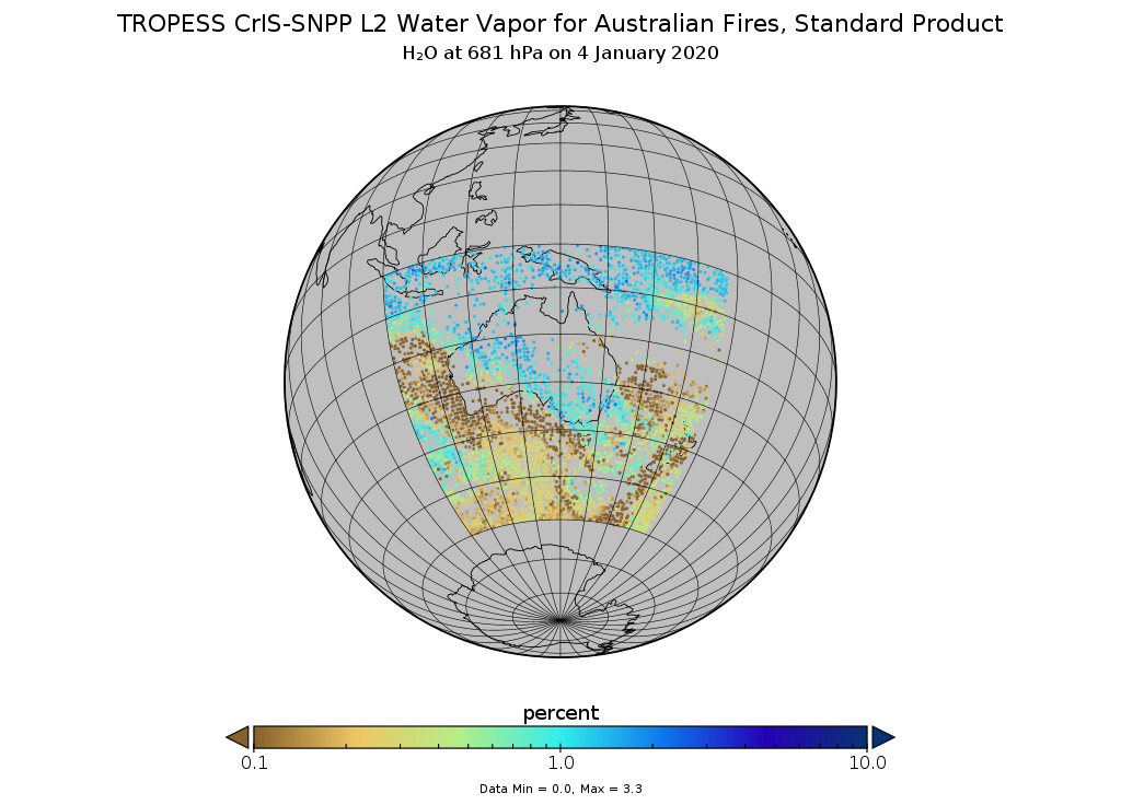
Federal
TROPESS CrIS-SNPP L2 Water for Australian Fires, Standard Product V1 (TRPSDL2H2OCRSAUS) at GES DISC
National Aeronautics and Space Administration —
The TROPESS CrIS-SNPP L2 Water for Australian Fires, Standard Product contains the vertical distribution of the retrieved atmospheric state of water vapor (H2O),... -
Federal
THIR/Nimbus-5 Level 1 Meteorological Radiation Data at 6.7 microns V001 (THIRN5L1CH67) at GES DISC
National Aeronautics and Space Administration —
THIRN5L1CH67 is the Nimbus-5 Temperature-Humidity Infrared Radiometer (THIR) Level 1 Meteorological Radiation Data at 6.7 microns product and contains radiances... -
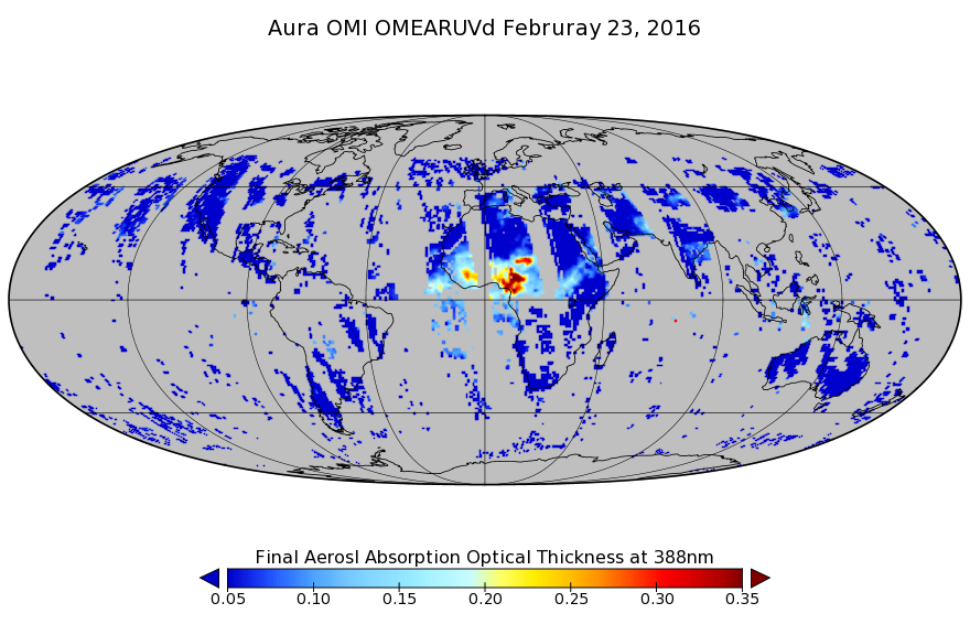
Federal
OMI/Aura Near UV Aerosol Optical Depth and Single Scattering Albedo L3 1 day 1.0 degree x 1.0 degree V3 (OMAERUVd) at GES DISC
National Aeronautics and Space Administration —
The OMI science team produces this Level-3 daily global gridded product OMAERUVd (1 deg Lat/Lon grids). The OMAERUVd product is produced with all data pixels that... -
Federal
OMPS-NPP L2 NP Ozone (O3) Vertical Profile swath orbital
National Aeronautics and Space Administration —
The OMPS-NPP L2 NP Ozone (O3) Total Column swath orbital product provides ozone profile retrievals from the Ozone Mapping and Profiling Suite (OMPS) Nadir-Profiler... -
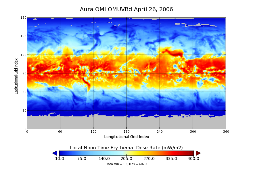
Federal
OMI/Aura Surface UVB Irradiance and Erythemal Dose Daily L3 Global Gridded 1.0 degree x 1.0 degree V3 (OMUVBd) at GES DISC
National Aeronautics and Space Administration —
This is Level-3 daily global gridded Aura-OMI Spectral Surface UVB Irradiance and Erythemal Dose product (OMUVBd). The OMUVBd product contains global erythemally...

Official websites use .gov
A
.gov website belongs to an official government
organization in the United States.
Secure .gov websites use HTTPS
A
lock (
) or https:// means you’ve safely connected to
the .gov website. Share sensitive information only on official,
secure websites.