

75 datasets found for "Water Sources"
-
Federal
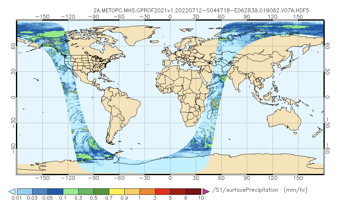
GPM MHS on METOP-C (GPROF) Radiometer Precipitation Profiling L2A 1.5 hours 17 km V07 (GPM_2AGPROFMETOPCMHS) at GES DISC
National Aeronautics and Space Administration —
Version 07 is the current version of the data set. The 2AGPROF (also known as, GPM GPROF (Level 2)) algorithm retrieves consistent precipitation and related science... -
Federal
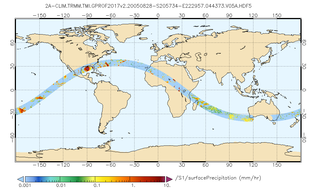
GPM TMI on TRMM (GPROF) Climate-based Radiometer Precipitation Profiling L2A 1.5 hours 13 km V07 (GPM_2AGPROFTRMMTMI_CLIM) at GES DISC
National Aeronautics and Space Administration —
This is the new (GPM-formated) TRMM product. It replaces the old TRMM_2A12 Version 07 is the current version of the data set. Older versions will no longer be... -
Federal
GPM MHS on METOP-B (GPROF) Climate-based Radiometer Precipitation Profiling L2A 1.5 hours 17 km V07 (GPM_2AGPROFMETOPBMHS_CLIM) at GES DISC
National Aeronautics and Space Administration —
Version 07 is the current version of the data set. Older versions are no longer available and have been superseded by Version 07. The "CLIM" products differ from... -
Federal
GPM ATMS on SUOMI-NPP (GPROF) Radiometer Precipitation Profiling L2 1.5 hours 16 km V07 (GPM_2AGPROFNPPATMS_CLIM) at GES DISC
National Aeronautics and Space Administration —
Version 07 is the current version of the data set. Older versions are no longer available and have been superseded by Version 07. The "CLIM" products differ from... -
Federal
GPM AMSR-2 on GCOM-W1 (GPROF) Climate-based Radiometer Precipitation Profiling L2A 1.5 hours 10 km V07 (GPM_2AGPROFGCOMW1AMSR2_CLIM) at GES DISC
National Aeronautics and Space Administration —
Version 07 is the current version of the data set. Older versions will no longer be available and have been superseded by Version 07. The 'CLIM' products differ from... -
Federal
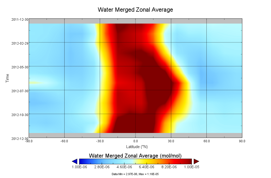
GOZCARDS Merged Water Vapor 1 month L3 10 degree Zonal Means on a Vertical Pressure Grid V1 (GozMmlpH2O) at GES DISC
National Aeronautics and Space Administration —
The GOZCARDS Merged Data for Water Vapor 1 month L3 10 degree Zonal Averages on a Vertical Pressure Grid product (GozMmlpH2O) contains zonal means and related... -
Federal
GOZCARDS Source Water Vapor 1 month L3 10 degree Zonal Means on a Vertical Pressure Grid V1 (GozSmlpH2O) at GES DISC
National Aeronautics and Space Administration —
The GOZCARDS Source Data for Water Vapor 1 month L3 10 degree Zonal Averages on a Vertical Pressure Grid product (GozSmlpH2O) contains zonal means and related... -
Federal
AMSR-E/Aqua level 3 global monthly Surface Soil Moisture Averages V005 (AMSRE_AVRMO) at GES DISC
National Aeronautics and Space Administration —
The dataset contains global monthly-mean soil moisture statistics (average values) for 1 by 1 degree grid cells. The source for the data is AMSR-E daily estimates of... -
Federal
AMSR-E/Aqua level 3 global monthly Surface Soil Moisture Standard Deviation V005 (AMSRE_STDMO) at GES DISC
National Aeronautics and Space Administration —
The dataset contains global monthly soil moisture statistics (standard deviation ) for 1 by 1 degree grid cells. The source for the data is AMSR-E daily estimates of... -
Federal
GPM SSM/I on F15 (GPROF) Climate-based Radiometer Precipitation Profiling L2 1.5 hours 12 km V07 (GPM_2AGPROFF15SSMI_CLIM) at GES DISC
National Aeronautics and Space Administration —
Version 07 is the current version of the data set. Older versions will no longer be available and have been superseded by Version 07.The 'CLIM' products differ from... -
Federal
GPM SSM/I on F13 (GPROF) Climate-based Radiometer Precipitation Profiling L2 1.5 hours 12 km V07 (GPM_2AGPROFF13SSMI_CLIM) at GES DISC
National Aeronautics and Space Administration —
Version 07 is the current version of the data set. Older versions will no longer be available and have been superseded by Version 07.The 'CLIM' products differ from... -
Federal
MERRA-2 tavg3_3d_mst_Np: 3d,3-Hourly,Time-Averaged,Pressure-Level,Assimilation,Moist Processes Diagnostics 0.625 x 0.5 degree V5.12.4 (M2T3NPMST) at GES DISC
National Aeronautics and Space Administration —
M2T3NPMST (or tavg3_3d_mst_Np) is a 3-dimensional 3-hourly time averaged data collection in Modern-Era Retrospective analysis for Research and Applications version 2... -
Federal
GLDAS Catchment Land Surface Model L4 3 hourly 1.0 x 1.0 degree V2.0 (GLDAS_CLSM10_3H) at GES DISC
National Aeronautics and Space Administration —
NASA Global Land Data Assimilation System Version 2 (GLDAS-2) has three components: GLDAS-2.0, GLDAS-2.1, and GLDAS-2.2. GLDAS-2.0 is forced entirely with the... -
Federal
GLDAS VIC Land Surface Model L4 3 hourly 1.0 x 1.0 degree V2.0 (GLDAS_VIC10_3H) at GES DISC
National Aeronautics and Space Administration —
NASA Global Land Data Assimilation System Version 2 (GLDAS-2) has three components: GLDAS-2.0, GLDAS-2.1, and GLDAS-2.2. GLDAS-2.0 is forced entirely with the... -
Federal
GLDAS Noah Land Surface Model L4 3 hourly 1.0 x 1.0 degree Early Product V2.1 (GLDAS_NOAH10_3H_EP) at GES DISC
National Aeronautics and Space Administration —
NASA Global Land Data Assimilation System Version 2 (GLDAS-2) has three components: GLDAS-2.0, GLDAS-2.1, and GLDAS-2.2. GLDAS-2.0 is forced entirely with the...
75 datasets found for "Water Sources"