
-
Federal
Sentinel-5P TROPOMI Aerosol Index 1-Orbit L2 5.5km x 3.5km V1 (S5P_L2__AER_AI_HiR) at GES DISC
National Aeronautics and Space Administration —
Starting from August 6th in 2019, Sentinel-5P TROPOMI along-track high spatial resolution (~5.5km at nadir) has been implemented.For data before August 6th of 2019,... -
Federal
Sentinel-5P TROPOMI Tropospheric Ozone Column V2 (S5P_L2__O3_TCL) at GES DISC
National Aeronautics and Space Administration —
Starting from July 13th in 2020, five Sentinel-5P TROPOMI level-2 products including total and tropospheric column ozone, sulfur dioxide, CLOUD, and formaldehyde have... -
Federal
Sentinel-5P TROPOMI Sulphur Dioxide SO2 1-Orbit L2 5.5km x 3.5km V2 (S5P_L2__SO2____HiR) at GES DISC
National Aeronautics and Space Administration —
Starting from August 6th in 2019, Sentinel-5P TROPOMI along-track high spatial resolution (~5.5km at nadir) has been implemented.Starting from July 13th in 2020, five... -
Federal
GLDAS Catchment Land Surface Model L4 daily 0.25 x 0.25 degree GRACE-DA1 V2.2 (GLDAS_CLSM025_DA1_D) at GES DISC
National Aeronautics and Space Administration —
NASA Global Land Data Assimilation System Version 2 (GLDAS-2) has three components: GLDAS-2.0, GLDAS-2.1, and GLDAS-2.2. GLDAS-2.0 is forced entirely with the... -
Federal
AIRS/Aqua L2G Precipitation Estimate (AIRS-only) V7.0 at GES DISC
National Aeronautics and Space Administration —
The Atmospheric Infrared Sounder (AIRS) is a grating spectrometer (R = 1200) aboard the second Earth Observing System (EOS) polar-orbiting platform, EOS Aqua. This... -
Federal
AIRS/Aqua L2G Precipitation Estimate (AIRS-only) V006 (AIRG2SSD_IRonly) at GES DISC
National Aeronautics and Space Administration —
The Atmospheric Infrared Sounder (AIRS) is a grating spectrometer (R = 1200) aboard the second Earth Observing System (EOS) polar-orbiting platform, EOS Aqua. This... -
Federal
AIRS/Aqua L1B Infrared (IR) geolocated and calibrated radiances V005 (AIRIBRAD) at GES DISC
National Aeronautics and Space Administration —
WARNING: On 2021/09/23 the EOS Aqua executed a Deep Space Maneuver (DSM). In the DSM, the spacecraft is turned such that the normal Earth field of regard is deep... -
Federal
MERRA-2 tavgU_3d_tdt_Np: 3d,diurnal,Time-Averaged,Pressure-Level,Assimilation,Temperature Tendencies 0.625 x 0.5 degree V5.12.4 (M2TUNPTDT) at GES DISC
National Aeronautics and Space Administration —
M2TUNPTDT (or tavgU_3d_tdt_Np) is a 3-dimensional monthly diurnal means data collection in Modern-Era Retrospective analysis for Research and Applications version 2... -
Federal
MERRA-2 tavgU_2d_csp_Nx: 2d,diurnal,Time-averaged,Single-Level,Assimilation,COSP Satellite Simulator 0.625 x 0.5 degree V5.12.4 (M2TUNXCSP) at GES DISC
National Aeronautics and Space Administration —
M2TUNXCSP (or tavgU_2d_csp_Nx) is a time-averaged 2-dimensional monthly diurnal means data collection in Modern-Era Retrospective analysis for Research and... -
Federal
GPM GMI Common Calibrated Brightness Temperatures Collocated L1C 1.5 hours 13 km V07 (GPM_1CGPMGMI) at GES DISC
National Aeronautics and Space Administration —
Version 07 is the current version of the data set. Older versions will no longer be available and have been superseded by Version 07.All 1C products have a common L1C... -
Federal
Sentinel-5P TROPOMI Irradiance product UVN module L1B V1 (S5P_L1B_IR_UVN) at GES DISC
National Aeronautics and Space Administration —
The Copernicus Sentinel-5 Precursor (Sentinel-5P or S5P) satellite mission is one of the European Space Agency's (ESA) new mission family - Sentinels, and it is a... -
Federal
Sentinel-5P TROPOMI Radiance product band 3 (UVIS detector) L1B 5.5km x 3.5km V1 (S5P_L1B_RA_BD3_HiR) at GES DISC
National Aeronautics and Space Administration —
Starting from August 6th in 2019, Sentinel-5P TROPOMI along-track high spatial resolution (~5.5km at nadir) has been implemented.For data before August 6th of 2019,... -
Federal
TROPESS CrIS-SNPP L2 for Delhi Megacity, Standard Product V1 (TRPSDL2ALLCRSMGDEL) at GES DISC
National Aeronautics and Space Administration —
The TROPESS CrIS-SNPP L2 for Delhi Megacity, Standard Product contains the vertical distribution of seven retrieved atmospheric gases (CH4, CO, H2O, HDO, NH3, O3 and... -
Federal
MLS/Aura Level 3 Daily Binned Geopotential Height (GPH) on Zonal and Similar Grids V005 (ML3DZGPH) at GES DISC
National Aeronautics and Space Administration —
ML3DZGPH is the EOS Aura Microwave Limb Sounder (MLS) daily binned on zonal and assorted vertical grids product for geopotential height (GPH) derived from radiances... -
Federal
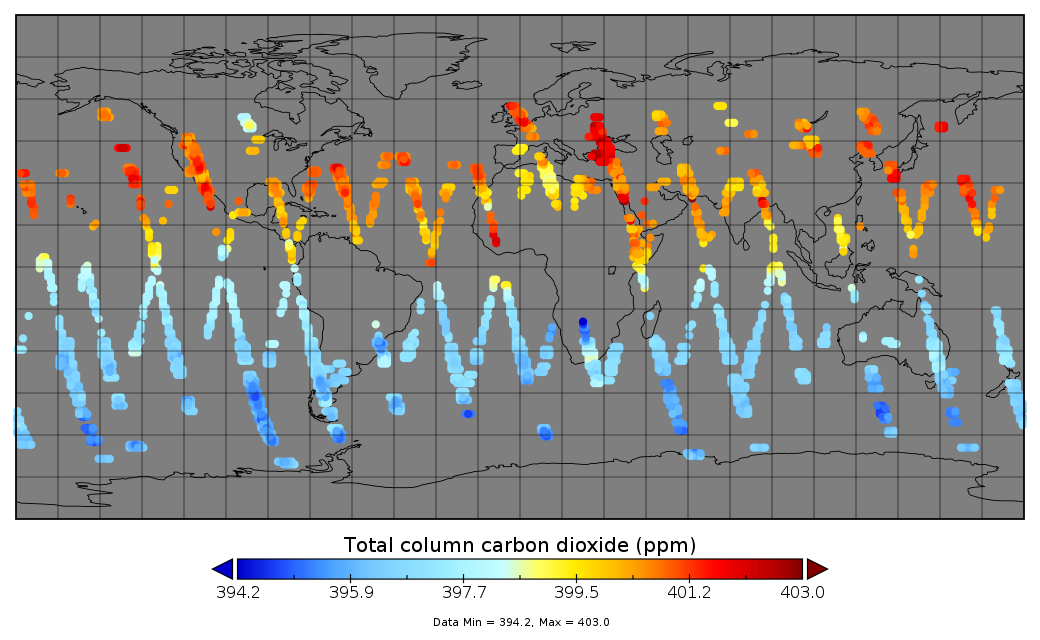
Multi-Instrument Fused bias-corrected XCO2 and other select fields aggregated as Level 4 daily files V3 (MultiInstrumentFusedXCO2)
National Aeronautics and Space Administration —
Gridded carbon dioxide mole fraction (XCO2) and other select variables created by applying local kriging (also known as optimal interpolation) to daily aggregates of... -
Federal
MLS/Aura Level 3 Monthly Binned Hydrogen Chloride (HCl) Mixing Ratio on Assorted Grids V005 (ML3MBHCL) at GES DISC
National Aeronautics and Space Administration —
ML3MBHCL is the EOS Aura Microwave Limb Sounder (MLS) monthly binned on various vertical grids product for hydrogen chloride (HCl) derived from radiances measured... -
Federal
MLS/Aura Level 3 Daily Binned Carbon Monoxide (CO) Mixing Ratio on Zonal and Similar Grids V004 (ML3DZCO) at GES DISC
National Aeronautics and Space Administration —
ML3DZCO is the EOS Aura Microwave Limb Sounder (MLS) daily binned on zonal and assorted vertical grids product for carbon monoxide (CO) derived from radiances... -
Federal
MLS/Aura Level 3 Daily Binned Carbon Monoxide (CO) Mixing Ratio on Zonal and Similar Grids V005 (ML3DZCO) at GES DISC
National Aeronautics and Space Administration —
ML3DZCO is the EOS Aura Microwave Limb Sounder (MLS) daily binned on zonal and assorted vertical grids product for carbon monoxide (CO) derived from radiances... -
Federal
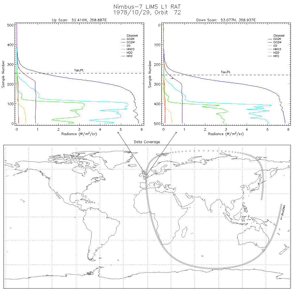
LIMS/Nimbus-7 Level 1 Radiance Data V001 (LIMSN7L1RAT) at GES DISC
National Aeronautics and Space Administration —
LIMSN7L1RAT is the Nimbus-7 Limb Infrared Monitor of the Stratosphere (LIMS) Level-1 Radiance Data product. It contains calibrated, earth-located radiances, as well... -
Federal
HIRDLS/Aura Level 3 Daily Gridded 1 x 1 deg Stratospheric Columns of NO2 V007 (HIR3SCOL) at GES DISC
National Aeronautics and Space Administration —
HIR3SCOL is the EOS High Resolution Dynamics Limb Sounder (HIRDLS/Aura) level 3 daily gridded 1 x 1 deg. stratospheric columns of NO2 (nitrogen dioxide) data product....

Official websites use .gov
A
.gov website belongs to an official government
organization in the United States.
Secure .gov websites use HTTPS
A
lock (
) or https:// means you’ve safely connected to
the .gov website. Share sensitive information only on official,
secure websites.