
-
Federal
ABoVE: Needle-Level Chlorophyll Fluorescence, Alaska and Idaho, USA, 2017 and 2019
National Aeronautics and Space Administration —
This dataset provides the results of in situ measurements of needle-level chlorophyll fluorescence (ChlF) obtained from a pulse amplitude modulated (PAM) fluorometer... -
Federal
ABoVE: Peak Greenness for Canadian Boreal Forest from Landsat 5 TM Imagery, 1984-2011
National Aeronautics and Space Administration —
This dataset provides a 28-year time series of peak greenness (NDVI) data derived from Landsat 5 TM imagery over the boreal forest region of Canada. Landsat 5 TM... -
Federal
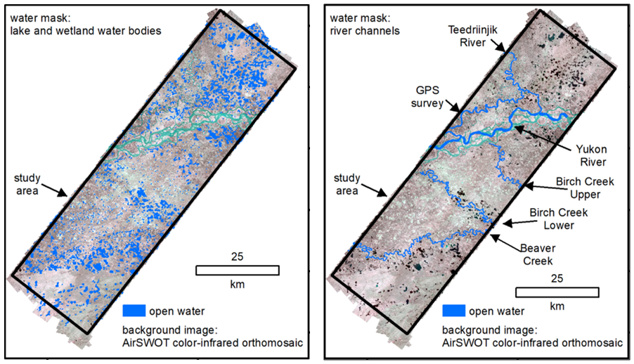
ABoVE: AirSWOT Radar, Orthomosaic, and Water Masks, Yukon Flats Basin, Alaska, 2015
National Aeronautics and Space Administration —
This dataset provides NASA AirSWOT Ka-band (35.75 GHz) radar interferometry data products for water surface elevation (WSE), a derived color-infrared (CIR) digital... -
Federal
BOREAS TGB-10 Oxidant Concentration Data over the SSA
National Aeronautics and Space Administration —
The BOREAS TGB-10 team collected several trace gas data sets in their efforts to determine the role of biogenic hydrocarbon emissions with respect to boreal forest... -
Federal
BOREAS TE-18 Landsat TM Physical Classification Image of the NSA
National Aeronautics and Space Administration —
The objective of this classification is to provide the BOREAS investigators with a data product that characterizes the land cover of the NSA. A Landsat-5 TM image... -
Federal
BOREAS RSS-17 Xylem Flux Density Measurements at the SSA-OBS Site
National Aeronautics and Space Administration —
As part of its efforts to determine environmental and phenological states from radar imagery, the BOREAS RSS-17 team collected in situ tree xylem flow measurements... -
Federal
BOREAS Follow-On DSP-10 Reclassified Regridded TM Mosaic Land Cover Maps, 1994
National Aeronautics and Space Administration —
These images were produced by aggregating a reclassified version of the 30-m land cover Thematic Mapper classification by CCRS and are now available at multiple... -
Federal
BOREAS Follow-On DSP-10 Regridded Moss Cover Maps for 1994
National Aeronautics and Space Administration —
Existing 1-km moss cover classifications were reprocessed and are now available at multiple resolutions (2 km, 10x5 minutes, and 0.5 degree). These data were... -
Federal
BASIN TCP Stable Isotope Composition of CO2 in Terrestrial Ecosystems
National Aeronautics and Space Administration —
This data set reports stable isotope ratio data of CO2 (13C/12C and 18O/16O) associated with photosynthetic and respiratory exchanges across the biosphere-atmosphere... -
Federal
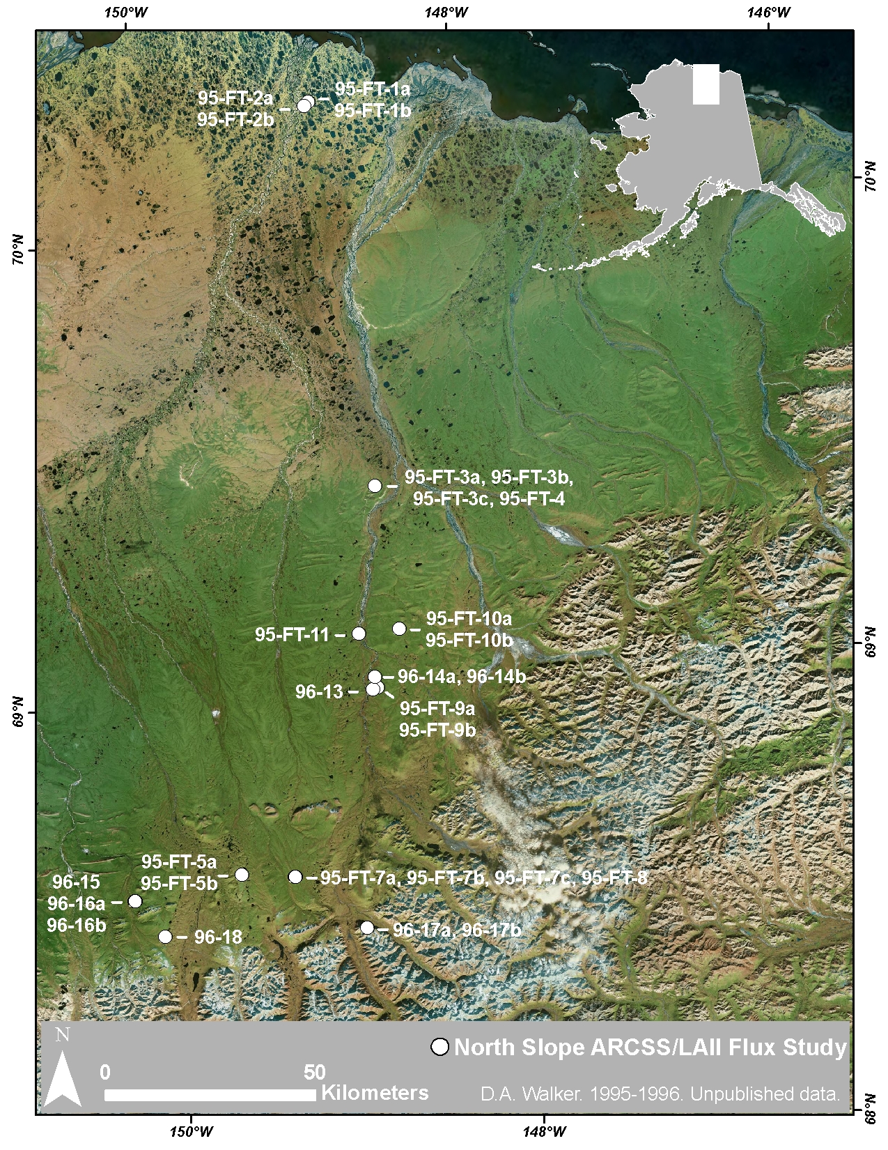
Arctic Vegetation Plots at ARCSS/LAII Flux Sites, North Slope, Alaska, 1995-1996
National Aeronautics and Space Administration —
This dataset provides vegetation cover and environmental plot and soil data collected at flux tower sites of the North Slope Arctic System Science/Land-Atmosphere-Ice... -
Federal
Delta-X: Root Stable Isotopes from Herbaceous Wetlands, MRD, LA, USA, August 2021
National Aeronautics and Space Administration —
This dataset contains carbon-13 (13C) and nitrogen-15 (15N) isotopic signatures of belowground root biomass samples from herbaceous wetlands in the Atchafalaya and... -
Federal
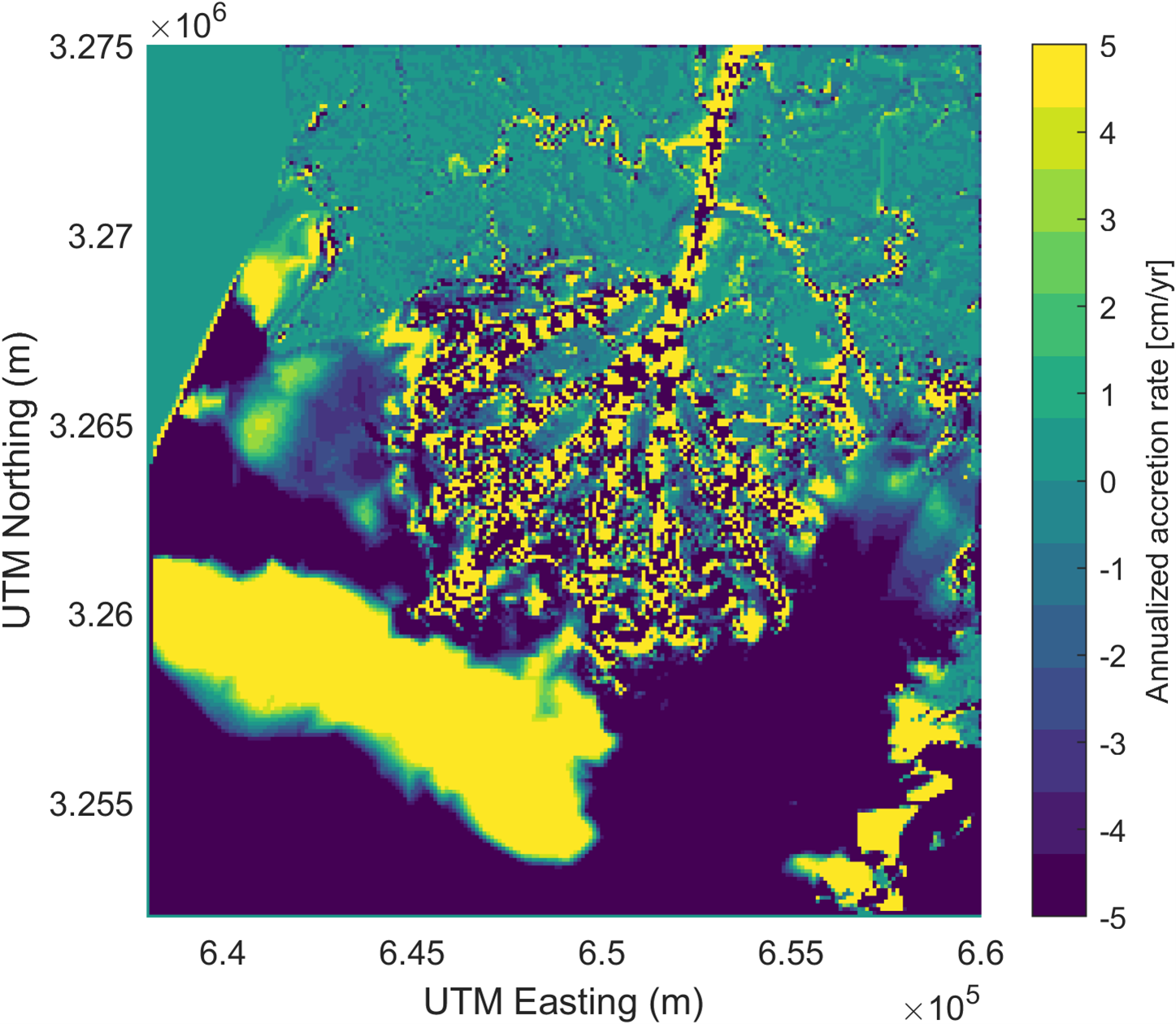
Delta-X: Modeled Land Accretion Rate Maps, Wax Lake Delta, MRD, LA, USA, 2021
National Aeronautics and Space Administration —
This dataset provides sediment transport and land accretion model results at Wax Lake Delta (WLD), Atchafalaya Basin, in coastal Louisiana, USA. Data were simulated... -
Federal
Delta-X: Land Subsidence Rate, Mississippi River Delta (MRD), Louisiana, USA
National Aeronautics and Space Administration —
This dataset provides estimates of land subsidence rates for the Delta-X domain area within the Atchafalaya and Terrebonne basins for 2021. The study area is a... -
Federal
Delta-X: Real-Time Kinematic Elevation Measurements for Coastal Wetlands, LA, 2021
National Aeronautics and Space Administration —
This dataset provides real-time kinematic (RTK) GPS elevation measurements, along with horizontal and vertical precision errors, obtained along transects near... -
Federal
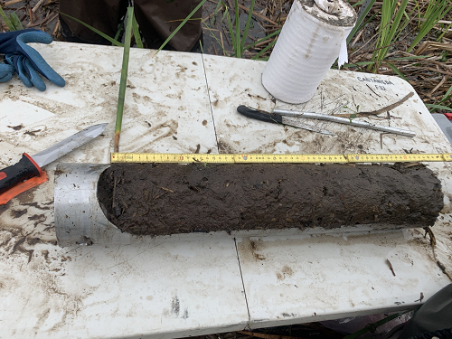
Delta-X: Sediment Core Grain Size Distribution, Wax Lake Delta, MRD, LA
National Aeronautics and Space Administration —
This dataset provides grain size distribution measurements collected from sediment core samples on Mike Island in the Wax Lake Delta, Louisiana, as part of the... -
Federal
BOREAS TF-11 Decomposition Data over the SSA-Fen
National Aeronautics and Space Administration —
The BOREAS TF-11 team collected several data sets in their efforts to fully describe the flux and site characteristics at the SSA-Fen site. This data set contains... -
Federal
BOREAS HYD-06 Moss/Humus Moisture Data
National Aeronautics and Space Administration —
This data set contains water content measurements of the moss/humus layer, where it existed. These data were collected along various flight lines in the Southern and... -
Federal
ATom: Comprehensive Aerosol Properties, 2016-2018, Version 2
National Aeronautics and Space Administration —
This dataset contains comprehensive measurements of aerosol microphysical, chemical, and optical properties derived for both dry and ambient conditions from in situ... -
Federal
ATom: Global Modeling Initiative (GMI) Chemical Transport Model (CTM) Output
National Aeronautics and Space Administration —
This dataset contains Global Modeling Initiative (GMI) Chemical Transport Model (CTM) outputs from the four Atom campaigns. GMI simulations of the ATom flight periods... -
Federal
Arctic Vegetation Plots in Flux Tower Footprints, North Slope, Alaska, 2014
National Aeronautics and Space Administration —
This data set provides vegetation, environmental, and soil data collected from plots located in the footprints of eddy covariance flux towers along a 300 km north-...

Official websites use .gov
A
.gov website belongs to an official government
organization in the United States.
Secure .gov websites use HTTPS
A
lock (
) or https:// means you’ve safely connected to
the .gov website. Share sensitive information only on official,
secure websites.