
-
Federal
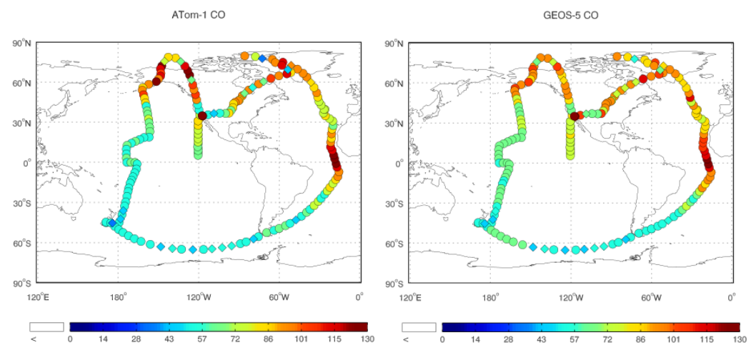
ATom: Observed and GEOS-5 Simulated CO Concentrations with Tagged Tracers for ATom-1
National Aeronautics and Space Administration —
This dataset contains carbon monoxide (CO) observations at 10-second intervals from flights during the ATom-1 campaign in 2016 and simulated CO concentrations from... -
Federal
BOREAS Level-1B MAS Imagery: At-Sensor Radiance, Relative X and Y Coordinates
National Aeronautics and Space Administration —
For BOREAS, the MAS images, along with the other remotely sensed data, were collected to provide spatially-extensive information over the primary study areas. This... -
Federal
Site Averaged Neutron Soil Moisture: 1987 (Betts)
National Aeronautics and Space Administration —
The Site Averaged Neutron Soil Moisture Data: 1987 (Betts) Data Set contains the site averaged product data of the neutron probe soil moisture collected during the... -
Federal
SAFARI 2000 Stem and Canopy Characterization, Kalahari Transect, 1995-2000
National Aeronautics and Space Administration —
This data set provides species distribution, basal area, height, and crown cover of woody stems at 10 sites along the Kalahari Transect where a large gradient in both... -
Federal
SAFARI 2000 Potential Vegetation, 5-min (Ramankutty and Foley)
National Aeronautics and Space Administration —
The data set consists of a southern Africa subset of the 5-min resolution Global Potential Vegetation data set developed by Navin Ramankutty and Jon Foley at the... -
Federal
NPP Multi-Biome: Global Osnabruck Data, 1937-1981, R1
National Aeronautics and Space Administration —
This data set contains three files. The first file provides net primary productivity (NPP) estimates, vegetation characteristics, and summary climate data for 720... -
Federal
LBA-ECO LC-21 Soil Characteristics, Logged Areas, Tapajos Forest, Para, Brazil: 2003
National Aeronautics and Space Administration —
This data set provides measurements for soil nutrients from areas that were selectively logged and from control areas in the Tapajos National Forest, Para Western... -
Federal
LBA-ECO CD-10 H2O Profiles at km 67 Tower Site, Tapajos National Forest
National Aeronautics and Space Administration —
This data set reports vertical profiles of H2O vapor concentrations measured at the Para Western (Santarem) - km 67, Primary Forest Tower Site (Figure 1). This site... -
Federal
LBA-ECO CD-06 CO2 Exchange in River Systems Across the Amazon Basin: 2004-2007
National Aeronautics and Space Administration —
This data set provides measurements of carbon dioxide flux rates (FCO2), gas transfer velocity (k), and partial pressures (pCO2) at 75 sites on rivers and streams of... -
Federal
ISLSCP II Global Gridded Soil Characteristics
National Aeronautics and Space Administration —
This data set provides gridded data for selected soil parameters derived from data and methods developed by the Global Soil Data Task, an international collaborative... -
Federal
ISLSCP II Globalview: Atmospheric CO2 Concentrations
National Aeronautics and Space Administration —
The GlobalView Carbon Dioxide (CO2) data product contains synchronized and smoothed time series of atmospheric CO2 concentrations at selected sites that were created... -
Federal
ABoVE: Burn Severity of Soil Organic Matter, Northwest Territories, Canada, 2014-2015
National Aeronautics and Space Administration —
This dataset provides maps at 30-m resolution of landscape surface burn severity (surface litter and soil organic layers) from the 2014-2015 fires in the Northwest... -
Federal
ABoVE: Soil Temperature Profiles, USArray Seismic Stations, AK and Canada, 2016-2019
National Aeronautics and Space Administration —
This dataset includes soil temperature profile measurements taken at 16 monitoring sites in Alaska, USA, and at one site in Yukon, Canada. The six sites are... -
Federal
FIFE CDROM Vol. 3 Contents: NS001 Thematic Mapper Simulator (TMS) Imagery, 1987-1989
National Aeronautics and Space Administration —
This data set provides aircraft-based NS001 Thematic Mapper Simulator (TMS) images of the study area associated with The First ISLSCP (International Satellite Land... -
Federal
Calculated Leaf Carbon and Nitrogen, 1992 (ACCP)
National Aeronautics and Space Administration —
The purpose of these measurements was to determine plot-level average leaf concentrations of nitrogen, lignin, cellulose, etc. in order to investigate how AVIRIS... -
Federal
MASTER: Airborne Science, California-Nevada, August, 2004
National Aeronautics and Space Administration —
This dataset includes Level 1B (L1B) data products from the MODIS/ASTER Airborne Simulator (MASTER) instrument. The spectral data were collected during one flight... -
Federal
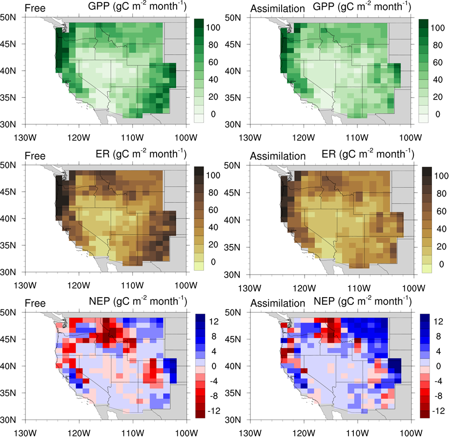
CLM5-DART Regional Carbon Fluxes and Stocks over the Western US, 1998-2010
National Aeronautics and Space Administration —
This dataset provides monthly estimates of biomass stocks and land-atmosphere carbon exchange across the western United States at 0.95 degrees longitude x 1.25... -
Federal
BOREAS TE-18 Landsat TM Physical Classification Image of the NSA
National Aeronautics and Space Administration —
The objective of this classification is to provide the BOREAS investigators with a data product that characterizes the land cover of the NSA. A Landsat-5 TM image...

Official websites use .gov
A
.gov website belongs to an official government
organization in the United States.
Secure .gov websites use HTTPS
A
lock (
) or https:// means you’ve safely connected to
the .gov website. Share sensitive information only on official,
secure websites.