
-
Federal
BOREAS NS001 TMS Level-0 Images in BIL Format
National Aeronautics and Space Administration —
For BOREAS, the NS001 TMS imagery, along with the other remotely sensed images, was collected in order to provide spatially extensive information over the primary... -
Federal
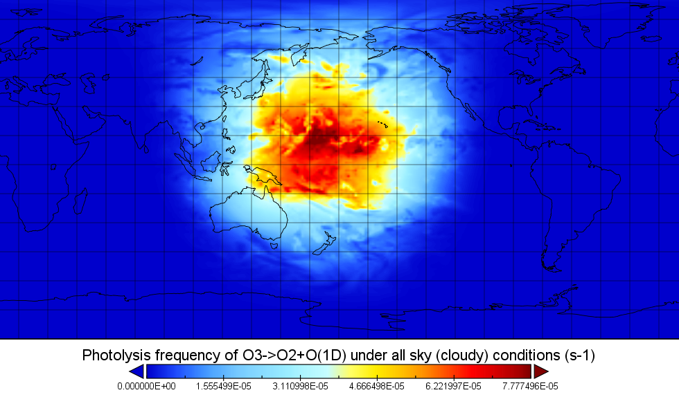
ATom: Global Modeled and CAFS Measured Cloudy and Clear Sky Photolysis Rates, 2016
National Aeronautics and Space Administration —
This dataset provides the results from nine global chemistry-climate or chemistry-transport models that estimated gridded values of atmospheric photolytic rates (J... -
Federal
Aspen Forest Cover by Stratum/Plot (SNF)
National Aeronautics and Space Administration —
The purpose of the Superior National Forest (SNF) study was to improve our understanding of the relationship between remotely sensed observations and important... -
Federal
BigFoot NPP Surfaces for North and South American Sites, 2000-2004
National Aeronautics and Space Administration —
The BigFoot project gathered Net Primary Production (NPP) data for nine EOS Land Validation Sites located from Alaska to Brazil from 2000 to 2004. Each site is... -
Federal
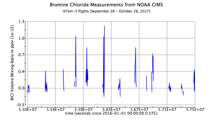
ATom: L2 Measurements from NOAA ToF Chemical Ionization Mass Spectrometer, Version 2
National Aeronautics and Space Administration —
This dataset provides the mixing ratios of reactive nitrogen and halogen species measured by the NOAA Iodide Ion Time-of-Flight Chemical Ionization Mass Spectrometer... -
Federal
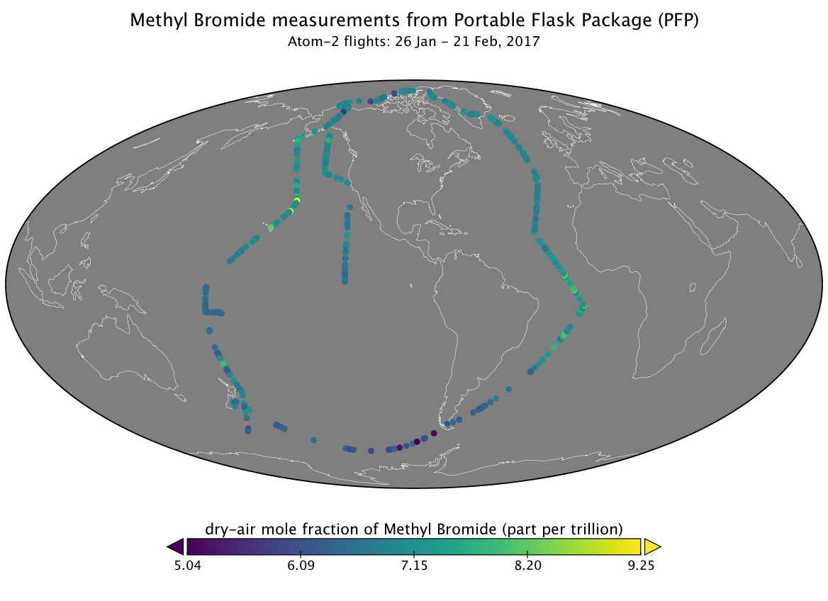
ATom: L2 Measurements from the Programmable Flask Package (PFP) Whole Air Sampler
National Aeronautics and Space Administration —
This dataset provides mole fractions of atmospheric trace gases measured by the Programmable Flask Package (PFP) Whole Air Sampler during airborne campaigns conducted... -
Federal
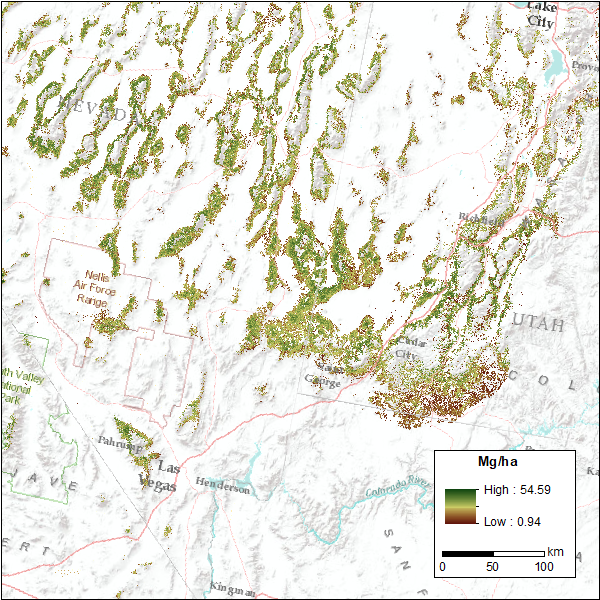
CMS: Pinyon-Juniper Forest Live Aboveground Biomass, Great Basin, USA, 2000-2016
National Aeronautics and Space Administration —
This dataset provides annual maps of live aboveground tree biomass (Mg/ha) for pinyon-juniper forests across the Great Basin of the Western USA for the years... -
Federal
CMS: Mangrove Canopy Height from High-resolution Stereo Image Pairs, Mozambique, 2012
National Aeronautics and Space Administration —
This data set provides canopy height estimates for mangrove forests at 0.6 x 0.6 m resolution in three study sites located in southeastern Mozambique, Africa: two... -
Federal
BOREAS TGB-01/TGB-03 Water Table and Peat Temperature Data over the NSA
National Aeronautics and Space Administration —
The BOREAS TGB-01 and TGB-03 teams collected several data sets that contributed to understanding the measured trace gas fluxes over sites in the NSA. This data set... -
Federal
BOREAS AFM-06 Mean Wind Profile Data
National Aeronautics and Space Administration —
The BOREAS AFM-06 team from the National Oceanic and Atmospheric Administration Environment Technology Laboratory (NOAA/ETL) operated a 915 MHz wind/Radio Acoustic... -
Federal
ATom: In Situ Data from Caltech Chemical Ionization Mass Spectrometer (CIT-CIMS), V2
National Aeronautics and Space Administration —
This dataset provides the concentrations of gas-phase organic and inorganic analytes measured by the California Institute of Technology (CIT) Chemical Ionization Mass... -
Federal
ATom: L2 In Situ Measurements of Aerosol Microphysical Properties (AMP)
National Aeronautics and Space Administration —
This dataset provides the number, surface area, and volume concentrations and size distributions of dry aerosol particles measured by the Aerosol Microphysical... -
Federal
ATom: L2 In Situ Measurements from Single Particle Soot Photometer (SP2)
National Aeronautics and Space Administration —
This dataset provides the refractory black carbon mass concentration at one-second resolution measured by the Single Particle Soot Photometer (NOAA SP2) instrument... -
Federal
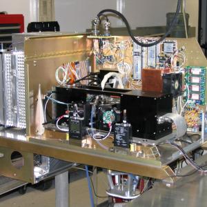
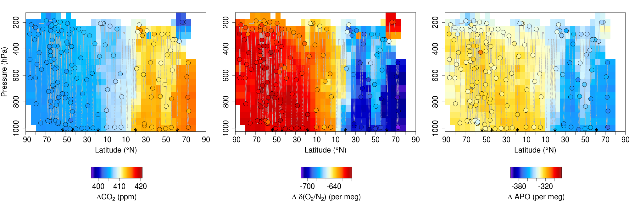
ATom: L2 In Situ Measurements from the NCAR Airborne Oxygen Instrument (AO2), V2
National Aeronautics and Space Administration —
This dataset provides in situ atmospheric oxygen and carbon dioxide concentrations measured by the NCAR Airborne Oxygen Instrument (AO2) during airborne campaigns... -
Federal
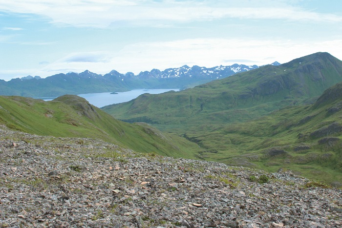
Arctic Vegetation Plots on Unalaska Island, Aleutian Islands, Alaska, 2007
National Aeronautics and Space Administration —
This data set provides environmental, soil, and vegetation data collected during August 2007 from 69 study plots at the Unalaska Island research site, and one plot on... -
Federal
BOREAS Level-0 AOCI Imagery: Digital Counts in BIL Format
National Aeronautics and Space Administration —
The level-0 AOCI imagery, along with the other remotely sensed images, was collected to provide spatially extensive information about radiant energy over the primary... -
Federal
BOREAS Level-1B TIMS Imagery: At Sensor Radiance in BSQ Format
National Aeronautics and Space Administration —
The BOREAS Staff Science Aircraft Data Acquisition Program focused on providing the research teams with the remotely sensed satellite data products they needed to... -
Federal
BOREAS HYD-03 Snow Water Equivalent Data
National Aeronautics and Space Administration —
The BOREAS HYD-03 team collected several data sets related to the hydrology of forested areas. This data set contains measurements of snow depth, snow density in 3-cm... -
Federal
ATom: Measurements from the Quantum Cascade Laser System (QCLS), Version 2
National Aeronautics and Space Administration —
This dataset provides atmospheric concentrations of CO2, CH4, CO, and N2O measured by the Harvard Quantum Cascade Laser System (QCLS) instruments during airborne... -
Federal
ATom: Measurements of Soluble Acidic Gases and Aerosols (SAGA)
National Aeronautics and Space Administration —
Soluble acidic gases and aerosols (SAGA) were collected with two related installations; a mist chamber/ion chromatography (MC/IC) system and a paired bulk aerosol...

Official websites use .gov
A
.gov website belongs to an official government
organization in the United States.
Secure .gov websites use HTTPS
A
lock (
) or https:// means you’ve safely connected to
the .gov website. Share sensitive information only on official,
secure websites.