

691 datasets found for "trees"
-
State
Aspen Characteristics - Sierra State Parks [ds379]
State of California —
The database represents point locations and associated stand assessment data collected within aspen stands on lands administrated by the Sierra District, California... -
Federal
Digital video, still imagery and dive narratives from the NOAA Office of Ocean Exploration's South Atlantic Bight 2001 cruises from 2001-08-29 to 2001-09-07
National Oceanic and Atmospheric Administration, Department of Commerce —
This collection contains digital video imagery, digital still imagery, and dive narratives from the NOAA Office of Ocean Exploration's South Atlantic Bight cruises,... -
City
DPD council districts shore clip - Absolute % Change
City of Seattle —
This data layer references data from a high-resolution tree canopy change-detection layer for Seattle, Washington. Tree canopy change was mapped by using remotely... -
Federal
A clustering method for repeat analysis in DNA sequences
U.S. Department of Health & Human Services —
Background A computational system for analysis of the repetitive structure of genomic sequences is described. The method uses suffix trees to organize and search the... -
Federal
Forest Biophysical Parameters (SNF)
National Aeronautics and Space Administration —
The purpose of the SNF study was to improve our understanding of the relationship between remotely sensed observations and important biophysical parameters in the... -
City
Louisville Metro KY - Russell WiFi Locations
Louisville Metro Government —
The difference from projected coverage area is due to the built and natural environment near the access points. For example, building and tree downgrade the signal... -
State
Tree Characteristics - Spears and Didion Ranches [ds320]
State of California —
4" dbh and within the 12.6 m radius plot. If a plot number is missing, then there were no trees at the sample points and vegetation plots. -
City
DPD council districts shore clip - Existing TC Percent
City of Seattle —
This data layer references data from a high-resolution tree canopy change-detection layer for Seattle, Washington. Tree canopy change was mapped by using remotely... -
Federal
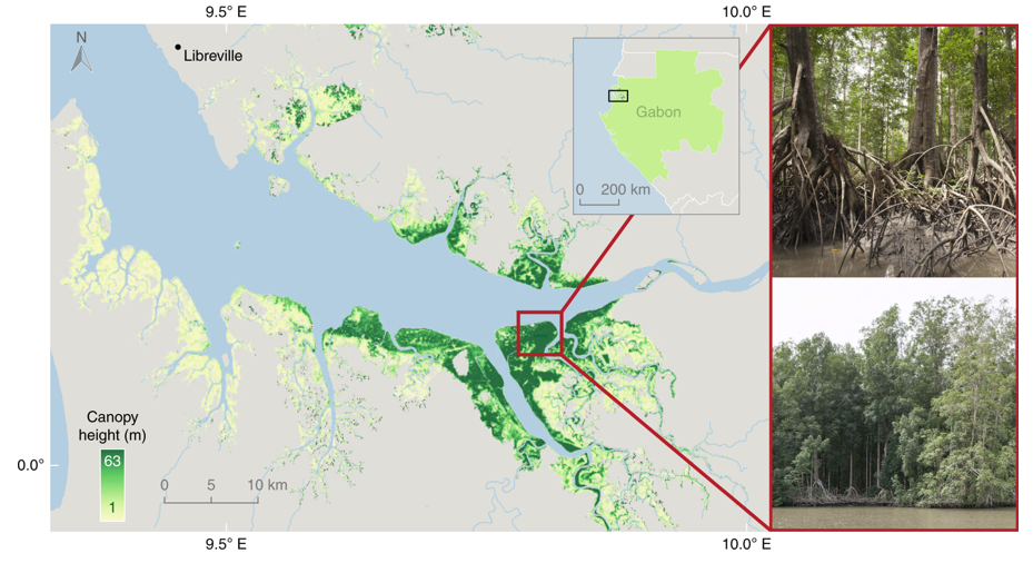
Global Mangrove Distribution, Aboveground Biomass, and Canopy Height
National Aeronautics and Space Administration —
This dataset characterizes the global distribution, biomass, and canopy height of mangrove-forested wetlands based on remotely sensed and in situ field measurement... -
Urban Tree Canopy by Ward in 2015
District of Columbia —
Polygons of Urban Tree Canopy in Washington, DC in 2015. These data represent detailed urban tree canopy cover in Washington, D.C. The data were derived using remote... -
State
California Tree Mortality Viewer
State of California —
Five long years of drought, combined with the increased infestation of native bark beetles as a result of the drought, have contributed to the death of millions of... -
Federal
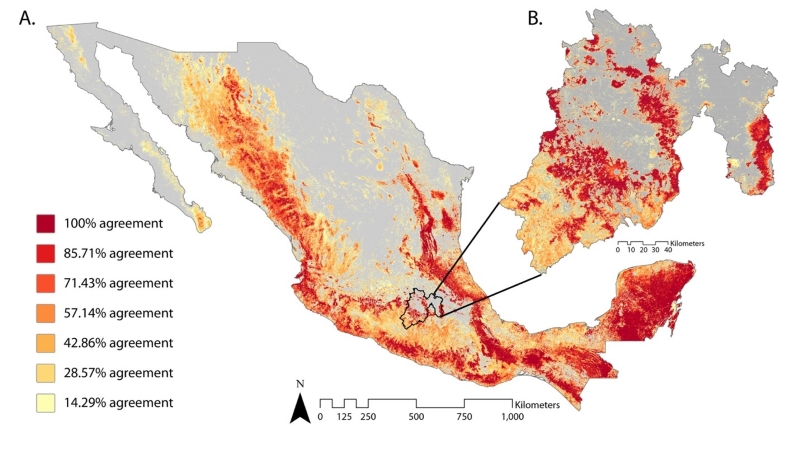
Satellite-Derived Forest Extent Likelihood Map for Mexico
National Aeronautics and Space Administration —
This dataset provides a comparison of forest extent agreement from seven remote sensing-based products across Mexico. These satellite-derived products include... -
State
CAL FIRE Working Forest Harvest Notices TA83
State of California —
Working Forest Management Plans (WFMPs) and Working Forest Harvest Notices (WFNs) approved by the California Department of Forestry and Fire Protection for landowners... -
Federal
Knutson-Vandenberg (Feature Layer)
Department of Agriculture —
Note: This is a large dataset. To download, go to ArcGIS Open Data Set and click the download button, and under additional resources select the shapefile or... -
Federal
Terrestrial Condition Assessment (TCA) Tree Mortality 0 to 5 years (Map Service)
Department of Agriculture —
Data are derived from 2015-2019 (0 - 5 years) aerial detection surveys for tree defoliation and mortality from the USFS Forest Health Assessment and Applied Sciences... -
Federal
LBA-ECO ND-07 Carbon and Nitrogen in Cerrado Plants and Soils, Brasilia: 1999-2000
National Aeronautics and Space Administration —
This data set provides (1) delta 15N ratios and nitrogen concentrations for foliar samples and (2) delta 13C and delta 15N ratios as well as carbon and nitrogen... -
Federal
BOREAS HYD-03 Canopy Density Data
National Aeronautics and Space Administration —
The BOREAS HYD-03 team collected several data sets related to the hydrology of forested areas. This data set contains measurements of canopy density (closure) from a... -
Federal
Forest Inventory and Analysis Bole Forest Biomass (Image Service)
Department of Agriculture —
The U.S. has been providing national-scale estimates of forest carbon stocks and stock change to meet United Nations Framework Convention on Climate Change reporting...
691 datasets found for "trees"