
-
Federal
CEOS Cal Val Test Site - Algeria 3 - Pseudo-Invariant Calibration Site (PICS) NGDA
National Aeronautics and Space Administration —
On the background of these requirements for sensor calibration, intercalibration and product validation, the subgroup on Calibration and Validation of the Committee... -
Federal
CEOS Cal Val Test Site - Libya 1 - Pseudo-Invariant Calibration Site (PICS) NGDA
National Aeronautics and Space Administration —
On the background of these requirements for sensor calibration, intercalibration and product validation, the subgroup on Calibration and Validation of the Committee... -
Federal
CERES Bidirectional Scans Aqua FM3 Edition1-CV
National Aeronautics and Space Administration —
CER_BDS_Aqua-FM3_Edition1-CV is the Clouds and the Earth's Radiant Energy System (CERES) Bidirectional Scans (BDS) Aqua Flight Model 3 (FM3) Edition1-CV data... -
Federal
CERES Bidirectional Scans JPSS-1 FM6 Edition1-CV
National Aeronautics and Space Administration —
CER_BDS_J01-FM6_Edition1-CV is the Clouds and the Earth's Radiant Energy System (CERES) Bidirectional Scans (BDS) Joint Polar Satellite System 1 (NOAA-20) Flight... -
Federal
SnowEx17 CRREL Differential GNSS Survey V001
National Aeronautics and Space Administration —
This data set contains the coordinates of SnowEx infrastructure in Grand Mesa, Colorado, collected through a differential GNSS real-time kinematic (RTK) survey. The... -
Federal
TRMM Microwave Imager Calibrated Radiances L1B 1.5 hours V7 (TRMM_1B11) at GES DISC
National Aeronautics and Space Administration —
This dataset contains TRMM Micrwave Imager (TMI) L1B calibrated radiances in terms of Brightness Temperatures. The TMI calibration algorithm (1B11) converts the... -
Federal
CEOS Cal Val Test Site - Dome C, Antarctica - Instrumented Site NGDA
National Aeronautics and Space Administration —
On the background of these requirements for sensor calibration, intercalibration and product validation, the subgroup on Calibration and Validation of the Committee... -
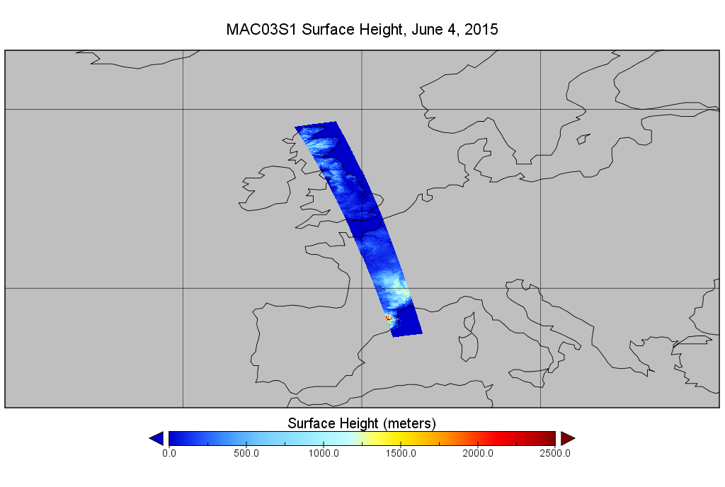
Federal
MODIS/Aqua Geolocation Fields 1km 5-Min 1A Narrow Swath Subset along CloudSat V002 (MAC03S0) at GES DISC NGDA
National Aeronautics and Space Administration —
This is the narrow-swath MODIS/Aqua subset along CloudSat field of view track. The goal of the narrow-swath subset is to select and return MODIS data that are within... -
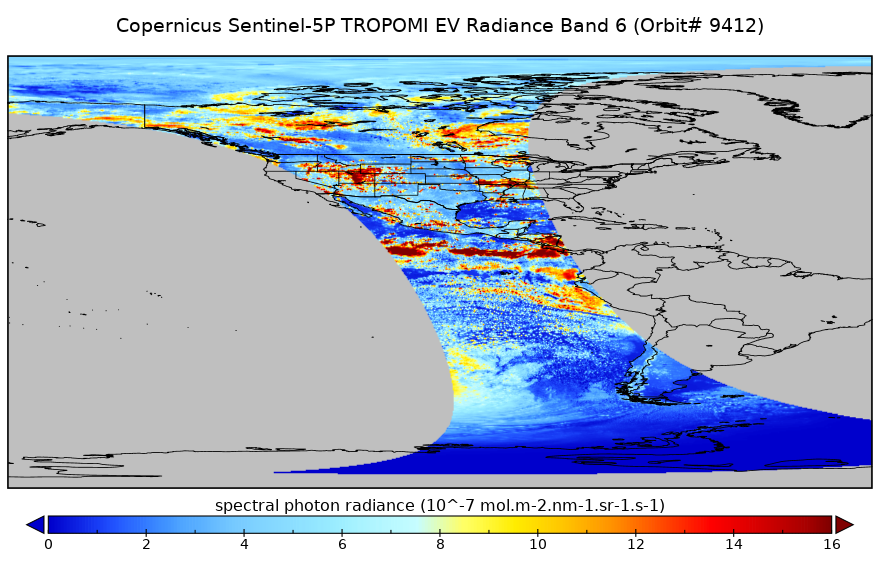
Federal
Sentinel-5P TROPOMI Radiance product band 6 (NIR detector) L1B 5.5km x 3.5km V2 (S5P_L1B_RA_BD6_HiR) at GES DISC
National Aeronautics and Space Administration —
Starting from August 6th in 2019, Sentinel-5P TROPOMI along-track high spatial resolution (~5.5km at nadir) has been implemented. For data before August 6th of 2019,... -
Federal
SLSTR/Sentinel-3B L1 Full Resolution Top of Atmosphere Radiances and Brightness Temperature
National Aeronautics and Space Administration —
The SLSTR/Sentinel-3B L1 Full Resolution Top of Atmosphere Radiances and Brightness Temperature product with shortname S3B_SL_1_RBT, is generated from the data... -
Federal
Likely Basal Thermal State of the Greenland Ice Sheet V002 NGDA
National Aeronautics and Space Administration —
The Likely Basal Thermal State of the Greenland Ice Sheet (GrIS) product contains key data sets that show how the likely basal thermal state was inferred from... -
Federal
MISR Motor Data V003
National Aeronautics and Space Administration —
MISR Level 1A Motor Data are acquired as part of an on-orbit calibration experiment. These data consist of measurements of the MISR instrument calibration panel motor... -
Federal
Sentinel-5P TROPOMI Radiance product band 8 (SWIR detector) L1B 5.5km x 7km V2 (S5P_L1B_RA_BD8_HiR) at GES DISC
National Aeronautics and Space Administration —
Starting from August 6th in 2019, Sentinel-5P TROPOMI along-track high spatial resolution (~5.5km at nadir) has been implemented. For data before August 6th of 2019,... -
Federal
NOAA-20 VIIRS On-Board Calibartion Product Data, version 2
National Aeronautics and Space Administration —
The VIIRS Geolocation Onboard Calibrator (OBC)-IP file contains solar diffuser observations, the associated gain state and HAM side information, and all engineering... -
Federal
CEOS Cal Val Test Site - Dunhuang, China - Instrumented Site NGDA
National Aeronautics and Space Administration —
On the background of these requirements for sensor calibration, intercalibration and product validation, the subgroup on Calibration and Validation of the Committee... -
Federal
CERES Bidirectional Scans Terra FM1 Edition1-CV
National Aeronautics and Space Administration —
CER_BDS_Terra-FM1_Edition1-CVis the Clouds and the Earth's Radiant Energy System (CERES) Bidirectional Scans (BDS) Terra Flight Model 1 (FM1) Edition1-CV data... -
Federal
Soil Moisture Active Passive (SMAP) L4 Soil Moisture Ancillary Catchment Model Tile Space V001
National Aeronautics and Space Administration —
This ancillary SMAP product contains tile information for the NASA Land Data Assimilation System (LDAS) Catchment model, including center-of-mass latitude/longitude,... -
Federal
MODIS/Aqua Geolocation Fields 1km 5-Min 1A Swath Subset along MLS V002 (MAM03S0) at GES DISC NGDA
National Aeronautics and Space Administration —
This is the MODIS/Aqua subset along the Microwave Limb Sounder (MLS) field of view track. The goal of the subset is to select and return MODIS data that are within...

Official websites use .gov
A
.gov website belongs to an official government
organization in the United States.
Secure .gov websites use HTTPS
A
lock (
) or https:// means you’ve safely connected to
the .gov website. Share sensitive information only on official,
secure websites.