
-
Federal
Terra MODIS Global Binned Particulate Inorganic Carbon (PIC) - Near Real Time (NRT) Data, version R2022.0 NGDA
National Aeronautics and Space Administration —
The Ocean Biology DAAC produces near real-time (quicklook) products using the best-available combination of ancillary data from meteorological and ozone data. As... -
Federal
Aqua MODIS Global Mapped Remote-Sensing Reflectance (RRS) - NRT Data, version R2022.0 NGDA
National Aeronautics and Space Administration —
The Ocean Biology DAAC produces near real-time (quicklook) products using the best-available combination of ancillary data from meteorological and ozone data. As... -
Federal
Terra MODIS Regional 4µm Nighttime Sea Surface Temperature (SST4) Data, version R2019.0 NGDA
National Aeronautics and Space Administration —
MODIS (or Moderate Resolution Imaging Spectroradiometer) is a key instrument aboard the Terra (EOS AM) and Aqua (EOS PM) satellites. Terra's orbit around the Earth is... -
Federal
MODIS Terra Level 3 SST Thermal IR Annual 4km Nighttime V2019.0 NGDA
National Aeronautics and Space Administration —
Day and night spatially gridded (L3) global NASA skin sea surface temperature (SST) products from the Moderate-resolution Imaging Spectroradiometer (MODIS) onboard... -
Federal
Aqua MODIS Global Binned 4µm Nighttime Sea Surface Temperature (SST4) Data, version R2019.0 NGDA
National Aeronautics and Space Administration —
MODIS (or Moderate Resolution Imaging Spectroradiometer) is a key instrument aboard the Terra (EOS AM) and Aqua (EOS PM) satellites. Terra's orbit around the Earth is... -
Federal
Aqua MODIS Global Mapped 11µm Nighttime Sea Surface Temperature (NSST) - Near Real Time (NRT) Data, version R2019.0 NGDA
National Aeronautics and Space Administration —
The Ocean Biology DAAC produces near real-time (quicklook) products using the best-available combination of ancillary data from meteorological and ozone data. As... -
Federal
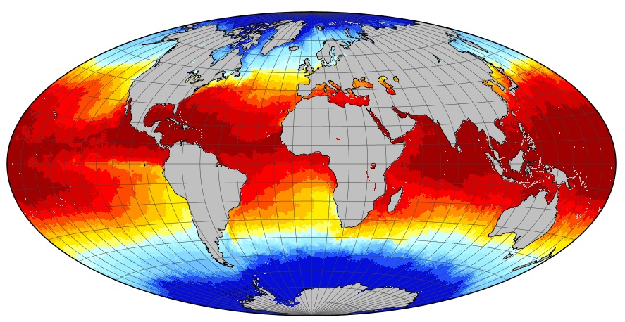
GHRSST Level 4 DMI_OI Global Foundation Sea Surface Temperature Analysis (GDS version 2) NGDA
National Aeronautics and Space Administration —
A Group for High Resolution Sea Surface Temperature (GHRSST) Level 4 sea surface temperature analysis produced daily on an operational basis by the Danish... -
Federal
MODIS Terra Level 3 SST Thermal IR Daily 4km Nighttime V2019.0 NGDA
National Aeronautics and Space Administration —
Day and night spatially gridded (L3) global NASA skin sea surface temperature (SST) products from the Moderate-resolution Imaging Spectroradiometer (MODIS) onboard... -
Federal
Terra MODIS Global Mapped 4µm Day/Night Sea Surface Temperature (SST4) - Near Real Time (NRT) Data, version R2019.0 NGDA
National Aeronautics and Space Administration —
The Ocean Biology DAAC produces near real-time (quicklook) products using the best-available combination of ancillary data from meteorological and ozone data. As... -
Federal
Aqua MODIS Global Binned Fluorescence Line Height (FLH) - Near Real Time (NRT) Data, version R2022.0 NGDA
National Aeronautics and Space Administration —
The Ocean Biology DAAC produces near real-time (quicklook) products using the best-available combination of ancillary data from meteorological and ozone data. As... -
Federal
Terra MODIS Global Binned Photosynthetically Active Radiation (PAR) Data, version R2022.0 NGDA
National Aeronautics and Space Administration —
MODIS (or Moderate-Resolution Imaging Spectroradiometer) is a key instrument aboard the Terra (EOS AM) and Aqua (EOS PM) satellites. Terra's orbit around the Earth is... -
Federal
Terra MODIS Global Binned Diffuse Attenuation Coefficient for Downwelling Irradiance (KD) - Near Real Time (NRT) Data, version R2022.0 NGDA
National Aeronautics and Space Administration —
The Ocean Biology DAAC produces near real-time (quicklook) products using the best-available combination of ancillary data from meteorological and ozone data. As... -
Federal
MODIS Terra Level 3 SST Thermal IR Daily 9km Nighttime V2019.0 NGDA
National Aeronautics and Space Administration —
Day and night spatially gridded (L3) global NASA skin sea surface temperature (SST) products from the Moderate-resolution Imaging Spectroradiometer (MODIS) onboard... -
Federal
MODIS Aqua Level 3 SST Thermal IR Annual 9km Daytime V2019.0 NGDA
National Aeronautics and Space Administration —
Day and night spatially gridded (L3) global NASA skin sea surface temperature (SST) products from the Moderate-resolution Imaging Spectroradiometer (MODIS) onboard... -
Federal
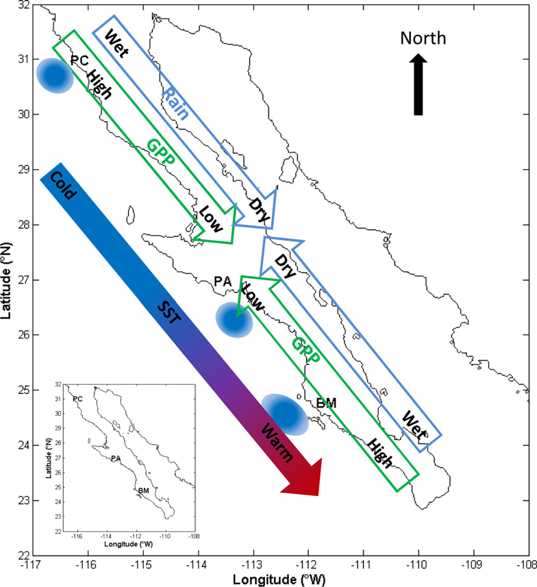
CMS: MODIS GPP, fPAR, and SST, and ENSO Index, Baja California, Mexico, 2000-2013 NGDA
National Aeronautics and Space Administration —
This data set provides data for MODIS-derived (1) gross primary productivity (GPP) for the years 2000-2010, (2) fraction of photosynthetically active radiation (fPAR)... -
Federal
Terra MODIS Global Binned Fluorescence Line Height (FLH) Data, version R2022.0 NGDA
National Aeronautics and Space Administration —
MODIS (or Moderate-Resolution Imaging Spectroradiometer) is a key instrument aboard the Terra (EOS AM) and Aqua (EOS PM) satellites. Terra's orbit around the Earth is... -
Federal
Terra MODIS Regional 11µm Day/Night Sea Surface Temperature (SST) - Near Real Time (NRT) Data, version R2019.0 NGDA
National Aeronautics and Space Administration —
The Ocean Biology DAAC produces near real-time (quicklook) products using the best-available combination of ancillary data from meteorological and ozone data. As... -
Federal
MODIS Aqua Level 3 SST MID-IR 8 Day 9km Nighttime V2019.0 NGDA
National Aeronautics and Space Administration —
Day and night spatially gridded (L3) global NASA skin sea surface temperature (SST) products from the Moderate-resolution Imaging Spectroradiometer (MODIS) onboard... -
Federal
MODIS Aqua Level 3 SST Thermal IR Daily 4km Daytime V2019.0 NGDA
National Aeronautics and Space Administration —
Day and night spatially gridded (L3) global NASA skin sea surface temperature (SST) products from the Moderate-resolution Imaging Spectroradiometer (MODIS) onboard... -
Federal
Aqua MODIS Global Mapped Chlorophyll (CHL) Data, version R2022.0 NGDA
National Aeronautics and Space Administration —
MODIS (or Moderate-Resolution Imaging Spectroradiometer) is a key instrument aboard the Terra (EOS AM) and Aqua (EOS PM) satellites. Terra's orbit around the Earth is...

Official websites use .gov
A
.gov website belongs to an official government
organization in the United States.
Secure .gov websites use HTTPS
A
lock (
) or https:// means you’ve safely connected to
the .gov website. Share sensitive information only on official,
secure websites.