
-
Federal
NY/NJ Metro Area, Hudson River, and South Long Island 2016 BIRDSPT Points
National Oceanic and Atmospheric Administration, Department of Commerce —
This data set contains sensitive biological resource data for raptors in the New York/New Jersey Metro Area, Hudson River, and South Long Island region. Vector points... -
Federal
Sensitivity of Coastal Environments and Wildlife to Spilled Oil: Hudson River: M_MAMMAL (Marine Mammal Polygons)
National Oceanic and Atmospheric Administration, Department of Commerce —
This data set contains sensitive biological resource data for marine mammals (seals) in the Hudson River. Vector polygons in this data set represent marine mammal... -
Federal
National Status and Trends, Benthic Surveillance Project Sites, 1984-1992, National Centers for Coastal Ocean Science
National Oceanic and Atmospheric Administration, Department of Commerce —
This data set reports information regarding the nominal sampling locations for the National Status and Trends Benthic Surveillance Project sites. One record is... -
Federal
Shoreline Data Rescue Project of Hudson River, NY, EC5D01A NGDA
National Oceanic and Atmospheric Administration, Department of Commerce —
These data were automated to provide an accurate high-resolution historical shoreline of Hudson River, NY suitable as a geographic information system (GIS) data... -
Federal
Shoreline Data Rescue Project of Hudson River, NY, EC5C01 NGDA
National Oceanic and Atmospheric Administration, Department of Commerce —
These data were automated to provide an accurate high-resolution historical shoreline of Hudson River, NY suitable as a geographic information system (GIS) data... -
Federal
Sensitivity of Coastal Environments and Wildlife to Spilled Oil: Hudson River: REPTILES (Reptile Polygons)
National Oceanic and Atmospheric Administration, Department of Commerce —
This data set contains sensitive biological resource data for estuarine reptiles (turtles, terrapins) and amphibians (salamanders, frogs) for the Hudson River. Vector... -
Federal
Hudson River Sub-Bottom Profile Lines_r09272010
National Oceanic and Atmospheric Administration, Department of Commerce —
Subbottom Profiler Tracklines. Data was collected November 5 to December 15, 2009, in the estuary north from Saugerties to Troy. Fugro utilized the GeoAcoustics... -
Federal
NY/NJ Metro Area, Hudson River, and South Long Island 2016 T_MAMMAL Polygons
National Oceanic and Atmospheric Administration, Department of Commerce —
This data set contains sensitive biological resource data for federally and/or state endangered, threatened, or rare small mammals and bats in the New York/New Jersey... -
Federal
NY/NJ Metro Area, Hudson River, and South Long Island 2016 HYDROP (Hydrography Polygons)
National Oceanic and Atmospheric Administration, Department of Commerce —
This data set contains vector polygons representing the coastal shoreline and hydrography used in the creation of the Environmental Sensitivity Index (ESI) for New... -
Federal
NY/NJ Metro Area, Hudson River, and South Long Island 2016 HABITATSPT Points
National Oceanic and Atmospheric Administration, Department of Commerce —
This data set contains sensitive biological resource data for federally and/or state endangered and threatened plants and rare state plants in the New York/New Jersey... -
Federal
Sensitivity of Coastal Environments and Wildlife to Spilled Oil: Hudson River: RVRMILES (River Mile Marker Lines)
National Oceanic and Atmospheric Administration, Department of Commerce —
This data set contains human-use resource data for river miles along the Hudson River. Vector lines in this data set represent river mile markers. This data set... -
Federal
Sensitivity of Coastal Environments and Wildlife to Spilled Oil: Hudson River: T_MAMMAL (Terrestrial Mammal Polygons)
National Oceanic and Atmospheric Administration, Department of Commerce —
This data set contains sensitive biological resource data for small terrestrial mammals (woodrats, myotis, muskrat, mink) for the Hudson River. Vector polygons in... -
Federal
NY/NJ Metro Area, Hudson River, and South Long Island 2016 BENTHIC Polygons
National Oceanic and Atmospheric Administration, Department of Commerce —
This data set contains sensitive biological resource data for marine and estuarine bivalve reefs and submerged aquatic vegetation (SAV) in the New York/New Jersey... -
Federal
NY/NJ Metro Area, Hudson River, and South Long Island 2016 HERP Polygons
National Oceanic and Atmospheric Administration, Department of Commerce —
This data set contains sensitive biological resource data for sea turtles, northern diamondback terrapins, and other federally and/or state endangered, threatened, or... -
Federal
Sensitivity of Coastal Environments and Wildlife to Spilled Oil: Hudson River: INDEX (Index Polygons)
National Oceanic and Atmospheric Administration, Department of Commerce —
This data set contains vector polygons representing the boundaries of all hardcopy cartographic products produced as part of the Environmental Sensitivity Index (ESI)... -
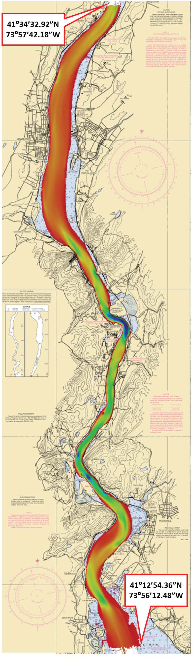
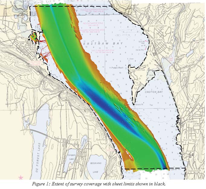
Federal
H13022: NOS Hydrographic Survey , 2017-08-09
National Oceanic and Atmospheric Administration, Department of Commerce —
The National Oceanic and Atmospheric Administration (NOAA) has the statutory mandate to collect hydrographic data in support of nautical chart compilation for safe... -
Federal
H13138: NOS Hydrographic Survey , 2018-08-06
National Oceanic and Atmospheric Administration, Department of Commerce —
The National Oceanic and Atmospheric Administration (NOAA) has the statutory mandate to collect hydrographic data in support of nautical chart compilation for safe... -
Federal
National Status and Trends, Benthic Surveillance Project Sites, 1984-1992, National Centers for Coastal Ocean Science
National Oceanic and Atmospheric Administration, Department of Commerce —
This data set reports information regarding the nominal sampling locations for the National Status and Trends Benthic Surveillance Project sites. One record is... -
Federal
H13023: NOS Hydrographic Survey , 2017-08-09
National Oceanic and Atmospheric Administration, Department of Commerce —
The National Oceanic and Atmospheric Administration (NOAA) has the statutory mandate to collect hydrographic data in support of nautical chart compilation for safe... -
Federal
NOAA Digital Oblique Imagery Collection for the Coasts of Main/New Hampshire, Massachusetts/Rhode Island/Connecticut, and Hudson River/Long Island /NY/NJ
National Oceanic and Atmospheric Administration, Department of Commerce —
Project: NOAA Digital Orthophotography and Ancillary Oblique Imagery Collection for the Coasts of Main/New Hampshire, Massachusetts/Rhode Island/Connecticut, and...

Official websites use .gov
A
.gov website belongs to an official government
organization in the United States.
Secure .gov websites use HTTPS
A
lock (
) or https:// means you’ve safely connected to
the .gov website. Share sensitive information only on official,
secure websites.