
-
Federal
TIGER/Line Shapefile, 2022, County, Baltimore County, MD, Feature Names Relationship File
U.S. Census Bureau, Department of Commerce —
The TIGER/Line shapefiles and related database files (.dbf) are an extract of selected geographic and cartographic information from the U.S. Census Bureau's Master... -
Federal
EnviroAtlas 51m Riparian Buffer Forest Cover Web Service
U.S. Environmental Protection Agency —
This EnviroAtlas web service supports research and online mapping activities related to EnviroAtlas (https://www.epa.gov/enviroatlas). This EnviroAtlas dataset... -
Federal
H00165: NOS Hydrographic Survey
National Oceanic and Atmospheric Administration, Department of Commerce —
The National Oceanic and Atmospheric Administration (NOAA) has the statutory mandate to collect hydrographic data in support of nautical chart compilation for safe... -
State
Choose Maryland: Compare Metros - Education
State of Maryland —
Educational attainment rates - high school diploma and bachelor's degree. -
Federal
EnviroAtlas - Baltimore, MD - EnviroAtlas Community Boundary
U.S. Environmental Protection Agency —
This EnviroAtlas dataset shows the Baltimore, MD EnviroAtlas community boundary. It represents the outside edge of all the block groups included in the EnviroAtlas... -
Federal
EnviroAtlas - Baltimore, MD - Estimated Intersection Density of Walkable Roads
U.S. Environmental Protection Agency —
This EnviroAtlas dataset estimates the intersection density of walkable roads within a 750 meter radius of any given 10 meter pixel in the community. Intersections... -
Federal
TIGER/Line Shapefile, 2022, County, Baltimore County, MD, Area Hydrography
U.S. Census Bureau, Department of Commerce —
The TIGER/Line shapefiles and related database files (.dbf) are an extract of selected geographic and cartographic information from the U.S. Census Bureau's Master... -
Federal
TIGER/Line Shapefile, 2023, County, Baltimore city, MD, Topological Faces-Area Hydrography Relationship File
U.S. Census Bureau, Department of Commerce —
The TIGER/Line shapefiles and related database files (.dbf) are an extract of selected geographic and cartographic information from the U.S. Census Bureau's Master... -
Federal
TIGER/Line Shapefile, 2023, County, Baltimore city, MD, Address Range-Feature
U.S. Census Bureau, Department of Commerce —
The TIGER/Line shapefiles and related database files (.dbf) are an extract of selected geographic and cartographic information from the U.S. Census Bureau's Master... -
Federal
EnviroAtlas - Baltimore, MD - Historic Places by Census Block Group
U.S. Environmental Protection Agency —
This EnviroAtlas dataset portrays the total number of historic places located within each Census Block Group (CBG). The historic places data were compiled from the... -
Federal
TIGER/Line Shapefile, 2020, County, Baltimore County, MD, Topological Faces (Polygons With All Geocodes)
U.S. Census Bureau, Department of Commerce —
The TIGER/Line shapefiles and related database files (.dbf) are an extract of selected geographic and cartographic information from the U.S. Census Bureau's Master... -
Federal
TIGER/Line Shapefile, 2022, County, Baltimore County, MD, Linear Hydrography
U.S. Census Bureau, Department of Commerce —
The TIGER/Line shapefiles and related database files (.dbf) are an extract of selected geographic and cartographic information from the U.S. Census Bureau's Master... -
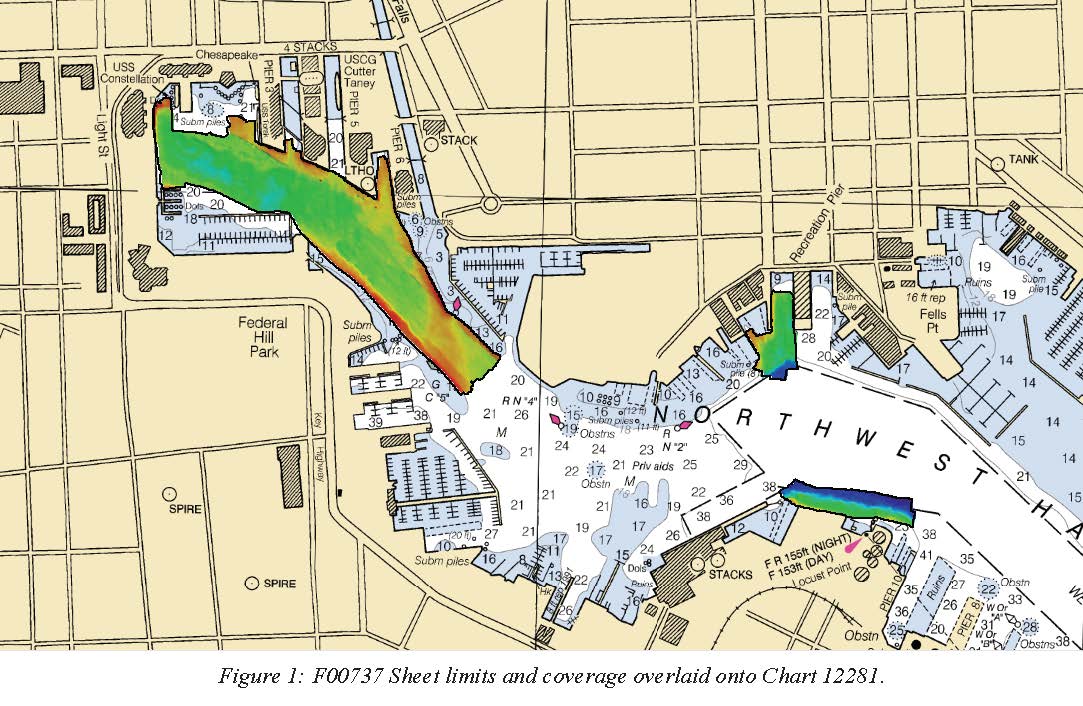
Federal
F00737: NOS Hydrographic Survey , 2018-08-08
National Oceanic and Atmospheric Administration, Department of Commerce —
The National Oceanic and Atmospheric Administration (NOAA) has the statutory mandate to collect hydrographic data in support of nautical chart compilation for safe... -
Federal
TIGER/Line Shapefile, Current, County, Baltimore County, MD, Address Range-Feature Name Relationship File
U.S. Census Bureau, Department of Commerce —
The TIGER/Line shapefiles and related database files (.dbf) are an extract of selected geographic and cartographic information from the U.S. Census Bureau's Master... -
Federal
EnviroAtlas - Baltimore, MD - Estimated Percent Tree Cover Along Walkable Roads
U.S. Environmental Protection Agency —
This EnviroAtlas dataset estimates tree cover along walkable roads. The road width is estimated for each road and percent tree cover is calculated in a 8.5 meter... -
Federal
TIGER/Line Shapefile, 2022, County, Baltimore city, MD, All Roads
U.S. Census Bureau, Department of Commerce —
The TIGER/Line shapefiles and related database files (.dbf) are an extract of selected geographic and cartographic information from the U.S. Census Bureau's Master... -
Federal
EnviroAtlas - Baltimore, MD - Residents with Minimal Potential Window Views of Trees by Block Group
U.S. Environmental Protection Agency —
This EnviroAtlas dataset shows the total block group population and the percentage of the block group population that has little access to potential window views of... -
Federal
Urban sediment and fallout radionuclide input characteristics of Dead Run watershed in Catonsville, Maryland for 2017-2018
Department of the Interior —
This metadata record documents two comma delimited tables that contain information on fallout radionuclides and urban sediments within Dead Run watershed in... -
Federal
EnviroAtlas - Baltimore, MD - Greenspace Around Schools by Block Group
U.S. Environmental Protection Agency —
This EnviroAtlas data set shows the number of schools in each block group in the EnviroAtlas community boundary as well as the number of schools where less than 25%... -
Federal
EnviroAtlas - Baltimore, MD - 51m Riparian Buffer Forest Cover
U.S. Environmental Protection Agency —
This EnviroAtlas dataset describes the percentage of a 51-m riparian buffer that is forested. In this community, tree cover is defined as Trees & Forest and Woody...

Official websites use .gov
A
.gov website belongs to an official government
organization in the United States.
Secure .gov websites use HTTPS
A
lock (
) or https:// means you’ve safely connected to
the .gov website. Share sensitive information only on official,
secure websites.