
-
Federal
H13446: NOS Hydrographic Survey , 2021-06-19
National Oceanic and Atmospheric Administration, Department of Commerce —
The National Oceanic and Atmospheric Administration (NOAA) has the statutory mandate to collect hydrographic data in support of nautical chart compilation for safe... -
Federal
H13919: NOS Hydrographic Survey , 2024-10-10
National Oceanic and Atmospheric Administration, Department of Commerce —
The National Oceanic and Atmospheric Administration (NOAA) has the statutory mandate to collect hydrographic data in support of nautical chart compilation for safe... -
Federal
H13924: NOS Hydrographic Survey , 2024-10-18
National Oceanic and Atmospheric Administration, Department of Commerce —
The National Oceanic and Atmospheric Administration (NOAA) has the statutory mandate to collect hydrographic data in support of nautical chart compilation for safe... -
Federal
H13444: NOS Hydrographic Survey , 2021-07-14
National Oceanic and Atmospheric Administration, Department of Commerce —
The National Oceanic and Atmospheric Administration (NOAA) has the statutory mandate to collect hydrographic data in support of nautical chart compilation for safe... -
Federal
H13668: NOS Hydrographic Survey , 2022-10-12
National Oceanic and Atmospheric Administration, Department of Commerce —
The National Oceanic and Atmospheric Administration (NOAA) has the statutory mandate to collect hydrographic data in support of nautical chart compilation for safe... -
Federal
Alaska Native Villages
Department of the Interior —
This dataset contains the tribal leadership locations as well as contact information for all 227 Alaska Native Villages. For a full list of Tribes in Alaska please... -
Federal
BLM Natl AIM TerrADat Hub
Department of the Interior —
This feature class includes monitoring data collected nationally to understand the status, condition, and trend of resources on BLM lands. It focuses on the BLM... -
Federal
TIGER/Line Shapefile, Current, State, Alaska, State Legislative District (SLD) Lower Chamber
U.S. Census Bureau, Department of Commerce —
This resource is a member of a series. The TIGER/Line shapefiles and related database files (.dbf) are an extract of selected geographic and cartographic information... -
Federal
TIGER/Line Shapefile, 2024, State, Alaska, AK, State Legislative District (SLD) Lower Chamber
U.S. Census Bureau, Department of Commerce —
The TIGER/Line shapefiles and related database files (.dbf) are an extract of selected geographic and cartographic information from the U.S. Census Bureau's Master... -
Federal
BLM Natl AIM LMF Hub
Department of the Interior —
This dataset was created to monitor the status, condition and trend of national BLM resources in accordance with BLM policies. It focuses on the BLM terrestrial core... -
Federal
Seascape Alaska 5: Gulf of Alaska ROV Exploration and Mapping
National Oceanic and Atmospheric Administration, Department of Commerce —
From August 23rd - September 14th, 2023 (Kodiak, Alaska to Seward, Alaska), NOAA Ocean Exploration conducted Seascape Alaska 5: Gulf of Alaska Remotely Operated... -
Federal
LANDFIRE 2022 Forest Canopy Bulk Density (CBD) AK
Department of the Interior —
LANDFIRE's (LF) 2022 Canopy Bulk Density (CBD) describes the mass of available canopy fuel per unit canopy volume that would burn in a crown fire. A spatially... -
Federal
Monitoring Trends in Burn Severity (MTBS) Conterminous United States
Department of Agriculture —
The Monitoring Trends in Burn Severity (MTBS) Program assesses the frequency, extent, and magnitude (size and severity) of all large wildland fires (wildfires and... -
Federal
Probabilistic Wildfire Risk Flame Length Probability 4 Alaska (Image Service)
Department of Agriculture —
Note: This image service has been consolidated into a unified service that now includes Alaska (AK), the Continental United States (CONUS), and Hawaii (HI). For... -
Federal
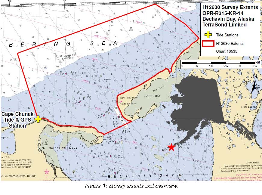
H12630: NOS Hydrographic Survey , 2014-08-14
National Oceanic and Atmospheric Administration, Department of Commerce —
The National Oceanic and Atmospheric Administration (NOAA) has the statutory mandate to collect hydrographic data in support of nautical chart compilation for safe... -
Federal
2020 Cartographic Boundary File (SHP), Current Place for Alaska, 1:500,000
U.S. Census Bureau, Department of Commerce —
The 2020 cartographic boundary shapefiles are simplified representations of selected geographic areas from the U.S. Census Bureau's Master Address File /... -
Federal
2022 Cartographic Boundary File (KML), Current Place for Alaska, 1:500,000
U.S. Census Bureau, Department of Commerce —
The 2022 cartographic boundary KMLs are simplified representations of selected geographic areas from the U.S. Census Bureau's Master Address File / Topologically... -
Federal
Probabilistic Wildfire Risk Flame Length Probability 2 Alaska (Image Service)
Department of Agriculture —
Note: This image service has been consolidated into a unified service that now includes Alaska (AK), the Continental United States (CONUS), and Hawaii (HI). For... -
Federal
H13567: NOS Hydrographic Survey , 2022-06-11
National Oceanic and Atmospheric Administration, Department of Commerce —
The National Oceanic and Atmospheric Administration (NOAA) has the statutory mandate to collect hydrographic data in support of nautical chart compilation for safe...

Official websites use .gov
A
.gov website belongs to an official government
organization in the United States.
Secure .gov websites use HTTPS
A
lock (
) or https:// means you’ve safely connected to
the .gov website. Share sensitive information only on official,
secure websites.