

90 datasets found
-
State
Iditarod survey area: Airborne magnetic and electromagnetic data in line, grid, vector, and map formats, and descriptive project report, Innoko, Iditarod, and McGrath mining districts, Iditarod and Ophir quadrangles, western Alaska
State of Alaska —
This digital publication, GPR 2011-4, contains Fugro Airborne Surveys' analysis and interpretation of data produced from airborne geophysical surveys published by... -
State
Fortymile mining district electromagnetic and magnetic airborne geophysical survey, data compilation
State of Alaska —
The Fortymile electromagnetic and magnetic airborne geophysical survey data were acquired with a DIGHEM-V Electromagnetic (EM) system and a cesium magnetometer. The... -
State
Northeast Fairbanks electromagnetic and magnetic airborne geophysical survey data compilation
State of Alaska —
The Northeast Fairbanks electromagnetic and magnetic airborne geophysical survey is located in interior Alaska in the Fairbanks and Circle mining districts, about 60... -
State
Kuskokwim airborne magnetic and radiometric survey, Kilbuck and Buckstock Mountains, Alaska
State of Alaska —
Kuskokwim airborne magnetic and radiometric survey, Kilbuck and Buckstock Mountains, Alaska, Geophysical Report 2025-5, covers parts of the Russian Mission,... -
State
Airborne magnetic geophysical survey of the Porcupine River area, Alaska
State of Alaska —
The Porcupine River fixed wing aeromagnetic geophysical survey is located in eastern Alaska, along the Canadian border, in the Sheenjek and Black mining districts.... -
State
Ketchikan electromagnetic and magnetic airborne geophysical survey data compilation
State of Alaska —
The Ketchikan geophysical survey is located in southeast Alaska in the Ketchikan area, about 350 kilometers south of Juneau, Alaska. Frequency domain electromagnetic... -
State
Kuskokwim airborne magnetic and radiometric survey, northern Kaiyuh Mountains, Alaska
State of Alaska —
Kuskokwim airborne magnetic and radiometric survey, northern Kaiyuh Mountains, Alaska, Geophysical Report 2025-3, covers parts of the the Nulato Quadrangle west of... -
State
Richardson electromagnetic and magnetic airborne geophysical survey data compilation
State of Alaska —
The Richardson electromagnetic and magnetic airborne geophysical survey is located in interior Alaska in the Richardson mining district, about 65 kilometers southeast... -
State
Icy Cape airborne magnetic geophysical survey, southeast Alaska
State of Alaska —
The Icy Cape airborne magnetic geophysical survey covers parts of Icy Cape, Alaska, which is located on the coast of the Gulf of Alaska near Icy Bay. Data were... -
Federal
Geothermal Data Gap Analysis Over the Western US
Department of Energy —
NREL, as part of the Play Fairway Analysis Retrospective, compiled and mapped publicly available geologic and geophysical data in relation to the 2008 USGS geothermal... -
State
Southern Dishna River electromagnetic and magnetic airborne geophysical survey data compilation
State of Alaska —
The Southern Dishna River survey is one of several geophysical surveys, collectively known as the Five Spot project (Southern Dishna River, Beaver Creek, and Fox... -
Federal
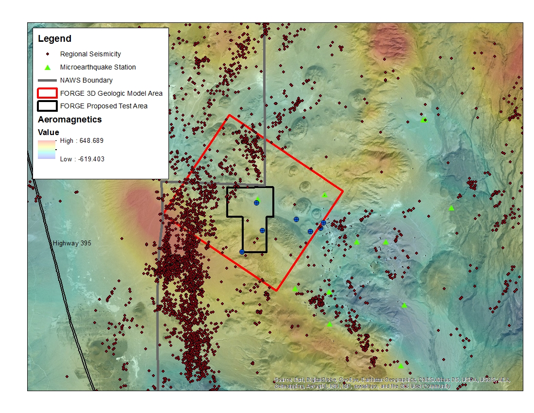
West Flank Coso, CA FORGE Test Area
Department of Energy —
A map with the Coso West Flank FORGE test area outlined, along with regional seismicity, the aeromagnetic data set and the area currently being utilized for the... -
State
Circle electromagnetic and magnetic airborne geophysical survey data compilation
State of Alaska —
This geophysical survey is located in north-central Alaska in the Circle mining district, about 120 kilometers northeast of Fairbanks, Alaska. Frequency domain... -
State
Styx River electromagnetic and magnetic airborne geophysical survey data compilation
State of Alaska —
This geophysical survey is located in the upper South Fork Kuskokwim River and Skwentna river drainages, southcentral Alaska. The Styx River survey is in the Yentna... -
State
Rampart - Manley electromagnetic and magnetic airborne geophysical survey data compilation
State of Alaska —
The Rampart - Manley electromagnetic and magnetic airborne geophysical survey is located in interior Alaska in the Rampart and Hot Springs mining districts, about 110... -
State
Petersville mining district electromagnetic and magnetic airborne geophysical survey data compilation
State of Alaska —
The Petersville mining district electromagnetic and magnetic airborne geophysical survey geophysical survey is located approximately 40 kilometers west of Talkeetna,... -
State
Iditarod electromagnetic and magnetic airborne geophysical survey data compilation
State of Alaska —
The Iditarod electromagnetic and magnetic airborne geophysical survey is located in the Iditarod, Innoko and McGrath mining districts, about 500 km southwest from... -
State
Kuskokwim airborne magnetic and radiometric geophysical survey, northern Kuskokwim Mountains
State of Alaska —
Kuskokwim airborne magnetic and radiometric geophysical survey, northern Kuskokwim Mountains, Geophysical Report 2023-1, covers parts of the Tanana, Norton Bay,... -
State
Aniak electromagnetic and magnetic airborne geophysical survey data compilation
State of Alaska —
The Aniak electromagnetic and magnetic airborne geophysical survey is located in western Alaska in the Iditarod and Aniak mining districts, about 450 kilometers west...
90 datasets found