
-
Federal
CERES SSF 1 degree Regionally Averaged TOA Fluxes, Clouds and Aerosols Hourly NPP VIIRS Edition2A recent views
National Aeronautics and Space Administration —
CER_SSF1deg-Hour_NPP-VIIRS_Edition2A is the Clouds and the Earth's Radiant Energy System (CERES) Single Scanner Footprint One Degree (SSF1deg) Regionally Averaged Top... -
Federal
MERRA-2 tavg3_3d_rad_Nv: 3d,3-Hourly,Time-Averaged,Model-Level,Assimilation,Radiation Diagnostics 0.625 x 0.5 degree V5.12.4 (M2T3NVRAD) at GES DISC recent views
National Aeronautics and Space Administration —
M2T3NVRAD (or tavg3_3d_rad_Nv) is a 3-dimensional 3-hourly time averaged data collection in Modern-Era Retrospective analysis for Research and Applications version 2... -
Federal
MOPITT Derived CO (Thermal Infrared Radiances) V009 recent views
National Aeronautics and Space Administration —
MOP02T_9 is the Measurements Of Pollution In The Troposphere (MOPITT) Derived Carbon Monoxide (CO) (Thermal Infrared Radiances) version 9 product. It consists of geo-... -
Federal
First ISCCP Regional Experiment (FIRE) Cirrus Phase II NCAR Sabreliner Aircraft Microphysical Data recent views
National Aeronautics and Space Administration —
The First ISCCP Regional Experiments have been designed to improve data products and cloud/radiation parameterizations used in general circulation models (GCMs).... -
Federal
First ISCCP Regional Experiment (FIRE) Atlantic Stratocumulus Transition Experiment (ASTEX) SOFIA Drifting Buoy Data recent views
National Aeronautics and Space Administration —
The First ISCCP Regional Experiments have been designed to improve data products and cloud/radiation parameterizations used in general circulation models (GCMs).... -
Federal
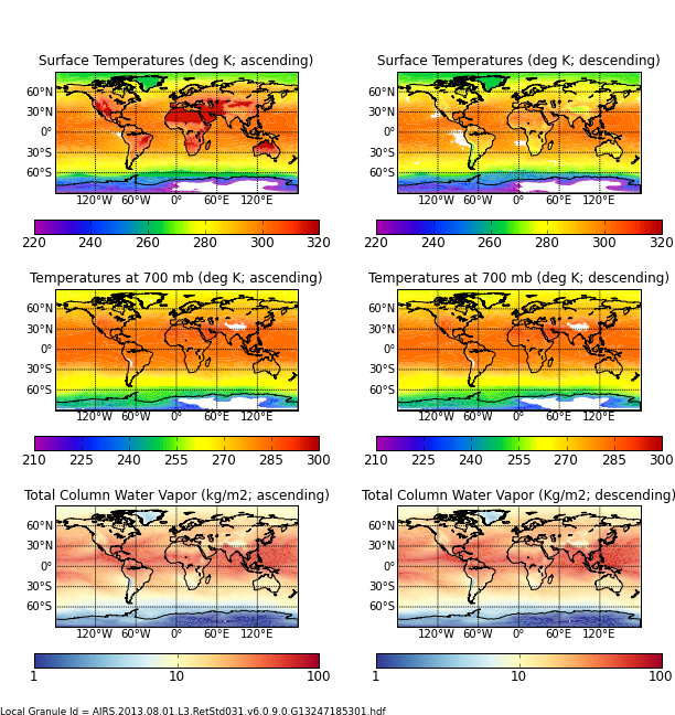
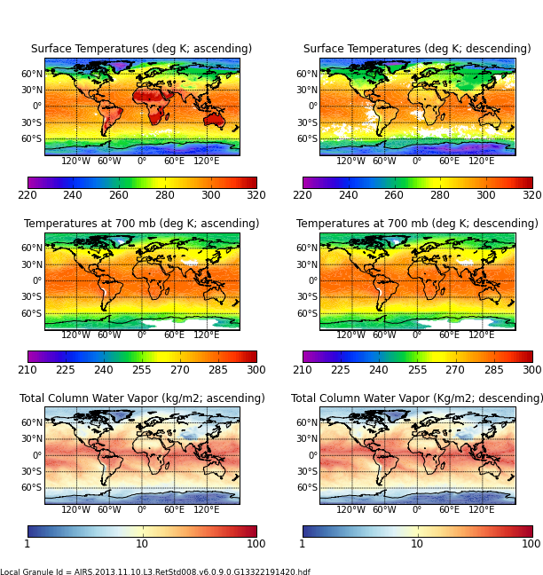
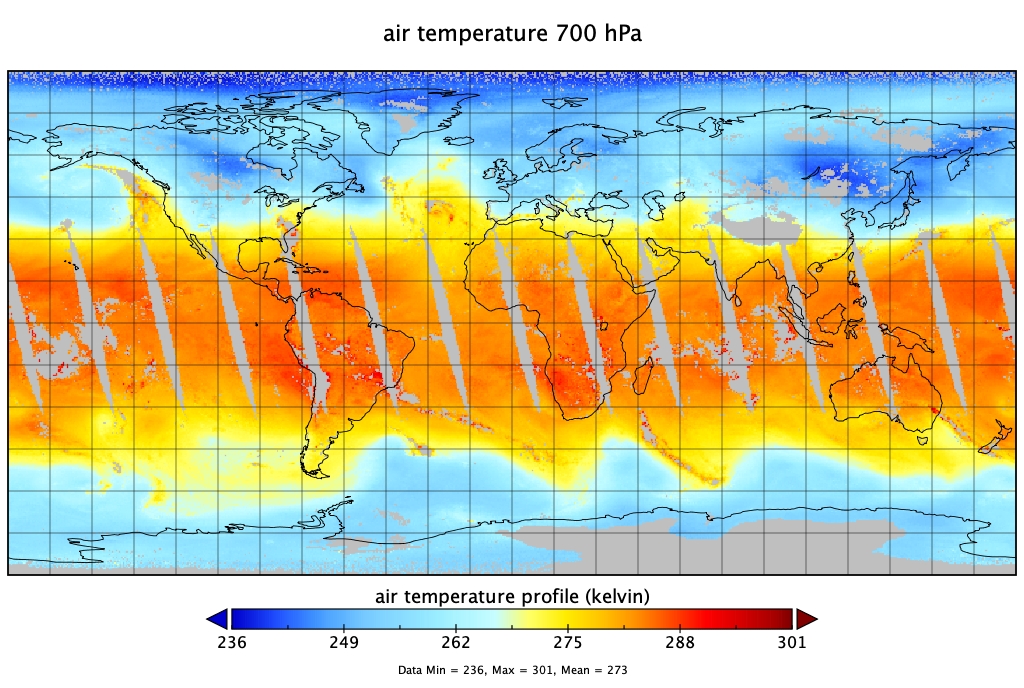
AIRS/Aqua L3 Monthly Standard Physical Retrieval (AIRS+AMSU) 1 degree x 1 degree V006 (AIRX3STM) at GES DISC recent views
National Aeronautics and Space Administration —
The Atmospheric Infrared Sounder (AIRS) is a grating spectrometer (R = 1200) aboard the second Earth Observing System (EOS) polar-orbiting platform, EOS Aqua. In... -
Federal
FLDAS Noah Land Surface Model L4 Global Monthly 0.1 x 0.1 degree (GDAS and CHIRPS-PRELIM) V001 (FLDAS_NOAH01_CP_GL_M) at GES DISC recent views
National Aeronautics and Space Administration —
This dataset contains a series of land surface parameters simulated from the Noah 3.6.1 model in the Famine Early Warning Systems Network (FEWS NET) Land Data... -
Federal
AIRS/Aqua L3 8-day Standard Physical Retrieval (AIRS-only) 1 degree X 1 degree V006 (AIRS3ST8) at GES DISC recent views
National Aeronautics and Space Administration —
The Atmospheric Infrared Sounder (AIRS) is a grating spectrometer (R = 1200) aboard the second Earth Observing System (EOS) polar-orbiting platform, EOS Aqua. In... -
Federal
GLDAS Noah Land Surface Model L4 monthly 1.0 x 1.0 degree V2.0 (GLDAS_NOAH10_M) at GES DISC recent views
National Aeronautics and Space Administration —
NASA Global Land Data Assimilation System Version 2 (GLDAS-2) has three components: GLDAS-2.0, GLDAS-2.1, and GLDAS-2.2. GLDAS-2.0 is forced entirely with the... -
Federal
GLDAS Noah Land Surface Model L4 monthly 0.25 x 0.25 degree Early Product V2.1 (GLDAS_NOAH025_M_EP) at GES DISC recent views
National Aeronautics and Space Administration —
NASA Global Land Data Assimilation System Version 2 (GLDAS-2) has three components: GLDAS-2.0, GLDAS-2.1, and GLDAS-2.2. GLDAS-2.0 is forced entirely with the... -
Federal
GLDAS Catchment Land Surface Model L4 monthly 1.0 x 1.0 degree V2.1 (GLDAS_CLSM10_M) at GES DISC recent views
National Aeronautics and Space Administration —
NASA Global Land Data Assimilation System Version 2 (GLDAS-2) has three components: GLDAS-2.0, GLDAS-2.1, and GLDAS-2.2. GLDAS-2.0 is forced entirely with the... -
Federal
SBU Mobile Soundings IMPACTS V1 recent views
National Aeronautics and Space Administration —
The SBU Mobile Sounding IMPACTS dataset consists of mobile sounding profiles collected during the Investigation of Microphysics and Precipitation for Atlantic Coast-... -
Federal
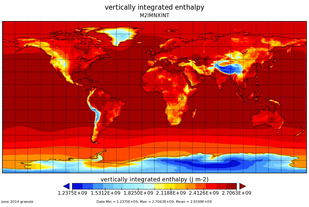
MERRA-2 instM_2d_int_Nx: 2d,Monthly mean,Instantaneous,Single-Level,Assimilation,Vertically Integrated Diagnostics 0.625 x 0.5 degree V5.12.4 (M2IMNXINT) at GES DISC recent views
National Aeronautics and Space Administration —
M2IMNXINT (or instM_2d_int_Nx) is an instantaneous 2-dimensional monthly mean data collection in Modern-Era Retrospective analysis for Research and Applications... -
Federal
NARSTO EPA Supersite (SS) Houston, Texas Air Quality Study 2000 (TexAQS2000) Department of Energy (DOE) G-1 Air Chemistry, Aerosol, and Met Data recent views
National Aeronautics and Space Administration —
NARSTO_EPA_SS_HOUSTON_TEXAQS2000_DOE_G-1_DATA is North American Research Strategy for Tropospheric Ozone (NARSTO) Environmental Protection Agency (EPA) Supersite (SS)... -
Federal
CERES and GEO-Enhanced TOA, Within-Atmosphere and Surface Fluxes, Clouds and Aerosols Monthly Terra-Aqua Edition4A NGDA recent views
National Aeronautics and Space Administration —
CER_SYN1deg-Month_Terra-Aqua-MODIS_Edition4A is the Clouds and the Earth's Radiant Energy System (CERES) and geostationary (GEO)-Enhanced Top of Atmosphere (TOA),... -
Federal
SOLVE II Rocket Data recent views
National Aeronautics and Space Administration —
SOLVE2_Rocket_Data is the rocketsonde data collected by falling sphere sounding during the SAGE III Ozone Loss and Validation Experiment II (SOLVE II). Data... -
Federal
LBA-ECO CD-01 Meteorological Data, Tapajos and Amazon Rivers, Santarem, Brazil: 2001 recent views
National Aeronautics and Space Administration —
This data set contains meteorological data collected around the confluence of the Tapajos River with the Amazon River in the Amazon Basin near Santarem, Brazil, in... -
Federal
Sounder SIPS: Suomi NPP CrIMSS Level 3 Specific Quality Control Gridded Daily SiFSAP V2 (SNDRSNIML3SDSFSP) at GES DISC recent views
National Aeronautics and Space Administration —
The SIFSAP (Single Field-of-View Sounder Atmospheric Products) algorithm provides retrieval for each sounder Field of View (FOV), therefore, it has 3-times higher... -
Federal
Aqua/AIRS L2 Near Real Time (NRT) Support Retrieval (AIRS-only) V7.0 at GES DISC recent views
National Aeronautics and Space Administration —
The Atmospheric Infrared Sounder (AIRS) Level 2 Near Real Time (NRT) Support Retrieval (AIRS-only) product (AIRS2SUP_NRT_7.0) differs from the routine product... -
Federal
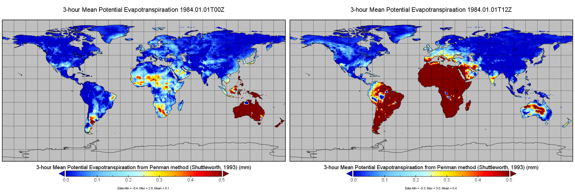
RM-OBS/PU Potential Evapotranspiration and Supporting Forcing L4 3-hourly 0.25x0.25 degree V001 (PET_PU_3H025) at GES DISC recent views
National Aeronautics and Space Administration —
The Princeton University MEaSUREs Potential Evapotranspiration (PET) dataset provides a set of estimates of PET based on near surface meteorology and surface...

Official websites use .gov
A
.gov website belongs to an official government
organization in the United States.
Secure .gov websites use HTTPS
A
lock (
) or https:// means you’ve safely connected to
the .gov website. Share sensitive information only on official,
secure websites.