

289 datasets found
-
Federal
Toxic Releases/IGD: EF_TRI recent views
U.S. Environmental Protection Agency —
EF_TRI is a subset of facilities from FRS_PROGRAM_FACILITY and associated best-available geospatial coordinates. Facility Registry Service (FRS) data are refreshed... -
Federal
Offshore Wind - Substations (Proposed or Installed) recent views
Department of the Interior —
MetadataThis data set contains both proposed and installed power substations. Substations can be within the offshore lease area or onshore. Offshore substations... -
Federal
E3: Economy - Energy - Environment; Supporting Manufacturing Leadership through Sustainability recent views
U.S. Environmental Protection Agency —
The E3 initiative is designed to help you thrive in a new business era focused on sustainability and, working together, to promote sustainable manufacturing and... -
City
Total Municipal Electricity Use FY2010 - FY2016 recent views
City of Providence —
Total municipal electricity use by property and department. -
Federal
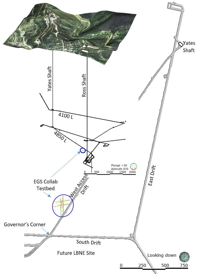
EGS Collab Experiment 2: Preliminary Test Wells Locations and Orientations recent views
Department of Energy —
The EGS Collab project is evaluating a site for Experiment 2 (hydraulic fracturing/shearing) at a depth of 1.25 km in the Sanford Underground Research Facility (SURF)... -
City
System Fuel Cost Average recent views
City of Austin —
The system fuel cost average is the cost of fuel purchased, divided by the number of kilowatts generated. View the system annual average fuel cost (cents/kWh)... -
City
Energy Efficiency Annual Energy Savings ( MWH) recent views
City of Austin —
Austin Energy provides rebates and low interest loans to customers who make energy efficiency improvements. During fiscal year 2012, energy savings totaled nearly... -
Federal
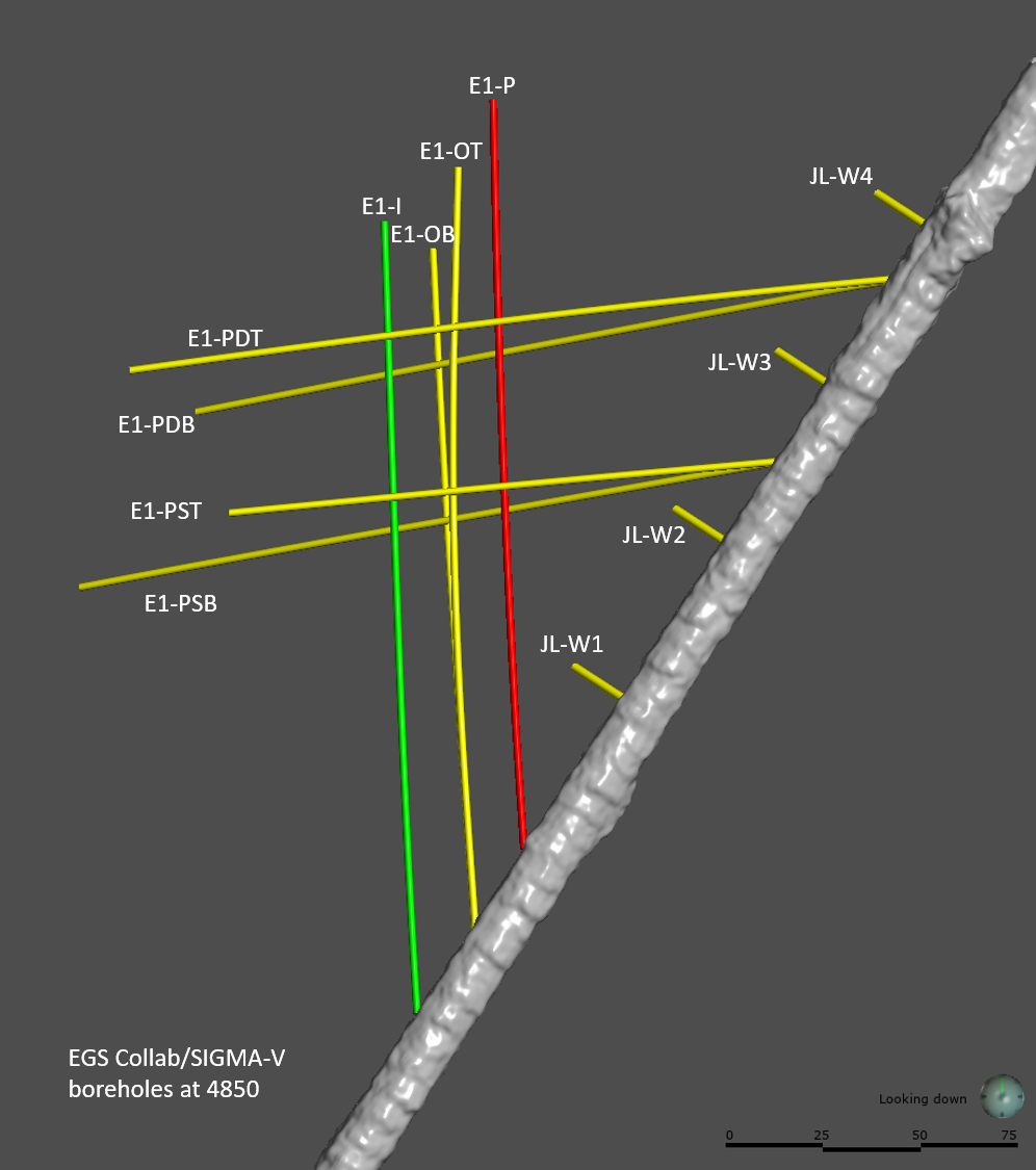
EGS Collab Experiment 1: Well Locations and Orientations. recent views
Department of Energy —
The EGS Collab is conducting experiments in hydraulic fracturing at a depth of 1.5 km in the Sanford Underground Research Facility (SURF) on the 4850 Level. A total... -
Federal
EGS Collab Experiment 2: Laser Scanned 4100 L Drift Map recent views
Department of Energy —
The EGS Collab project is evaluating a site for Experiment 2 (hydraulic fracturing/shearing) at a depth of 1.25 km in the Sanford Underground Research Facility (SURF)... -
Federal
Limit of "8(g) Zone" - Pacific Region West Coast NGDA recent views
Department of the Interior —
This data set contains Pacific OCS Region - West Coast scale Limit of "8(g) Zone" line. The Outer Continental Shelf Lands Act "8(g) Zone" lies between the Submerged... -
Federal
BLM Natl Visual Resource Inventory Classes Polygon recent views
Department of the Interior —
The Visual Resource Inventory Classes Polygon is a component of the Visual Resources Inventory (VRI) and includes information needed for inventorying for visual... -
Federal
EMF37 Raw Data USAMXCAN recent views
U.S. Environmental Protection Agency —
EMF 37 analyzed scenarios for economy-wide net zero carbon dioxide emissions in North America by midcentury. Sixteen modeling teams explored technology evolutions,... -
City
Power Plants recent views
City of Austin —
Austin Energy generates power through a diverse generation portfolio of natural gas, coal, nuclear, renewable resources and purchased power. Browse data about our... -
State
Utility Energy Registry Monthly Community Energy Use: 2016-2021 recent views
State of New York —
The Utility Energy Registry (UER) is a database platform that provides streamlined public access to aggregated community-scale utility-reported energy data. The UER... -
DOEE Services in Last 30 Days recent views
District of Columbia —
Data provided here are from the DC's 311 service request center. They represent all service requests such as abandoned automobiles, parking meter repair and bulk trash... -
Federal
WHOLESCALE: Coordinates of wells at San Emidio, Nevada recent views
Department of Energy —
This dataset includes position coordinates and elevation information for wells at the WHOLESCALE San Emidio project location. Well positions in the attached file are... -
County
Municipal Building Energy Usage recent views
Allegheny County / City of Pittsburgh / Western PA Regional Data Center —
This data set contains energy use data from 2009-2014 for 139 municipally operated buildings. Metrics include: Site & Source EUI, annual electricity, natural gas... -
Federal
EGS Collab Experiment 1: 3D Seismic Velocity Model and Updated Microseismic Catalog Using Transfer-Learning Aided Double-Difference Tomography recent views
Department of Energy —
This package contains a 3D Seismic velocity model and an updated microseismic catalog associated with a proceedings paper (Chai et al., 2020) published in the 45th...
289 datasets found