

54 datasets found for "zip codes"
-
Federal
SAFARI 2000 Carbon in Live Vegetation, 0.5-Deg (Olson)
National Aeronautics and Space Administration —
This data set is a subset of Olson's Major World Ecosystem Complexes for southern Africa in ASCII GRID and binary image files formats. Olson's Major World Ecosystem... -
Federal
NPP Multi-Biome: Gridded Estimates for Selected Regions Worldwide, 1954-1998, R3
National Aeronautics and Space Administration —
This data set provides two data files (.csv format) containing gridded (0.5-degree) estimates of net primary productivity (NPP), elevation, temperature,... -
Federal
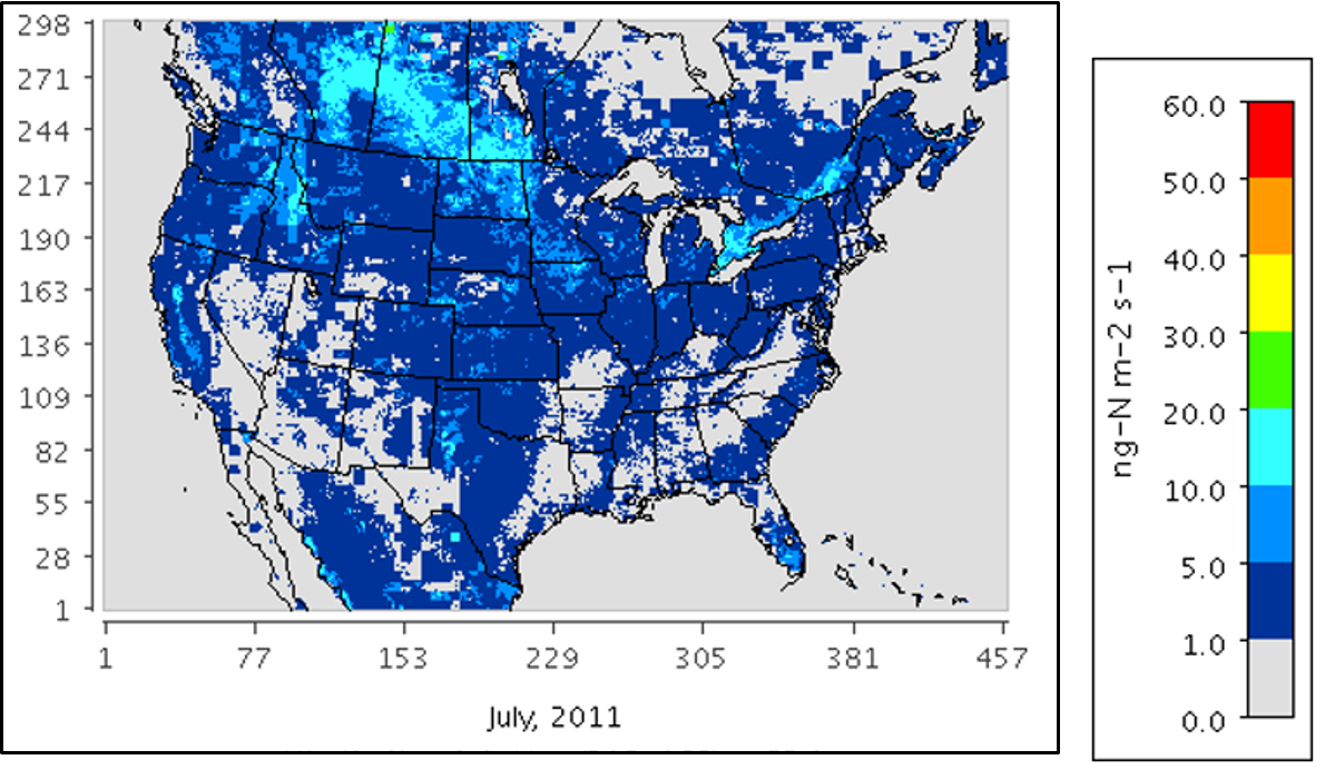
Mechanistic Module for Soil Nitrogen Emissions for CMAQ Model, North America, 2011
National Aeronautics and Space Administration —
This model product provides source code, input data files, and example model outputs for a new mechanistic soil nitrogen (N) module in-line with the Community... -
Federal
LINKAGES: An Individual-based Forest Ecosystem Biogeochemistry Model
National Aeronautics and Space Administration —
This model product contains the source codes for version 1 of the individual-based forest ecosystem biogeochemistry model LINKAGES and two subsequent versions as well... -
Federal
LBA-ECO CD-04 LAI Estimated from Photos, km 83 Tower Site, Tapajos National Forest
National Aeronautics and Space Administration —
This data set contains summary data for monthly leaf area index (LAI) and plant area index (PAI) at the km 83 Tower Site, in the Tapajos National Forest, Para,... -
Federal
LBA Regional Carbon in Live Vegetation, 0.5-degree (Olson)
National Aeronautics and Space Administration —
This data set is a subset of Olson et al. (1985, 2000) "Major World Ecosystem Complexes Ranked by Carbon in Live Vegetation." This subset was created for the study... -
Federal
Lund-Potsdam-Jena Wetland Hydrology and Methane DGV Model (LPJ-WHyMe v1.3.1)
National Aeronautics and Space Administration —
This model product provides the Fortran 77 source code for the Lund-Potsdam-Jena (LPJ) Wetland Hydrology and Methane Dynamic Global Vegetation Model (LPJ-WHyMe... -
Federal
Global Soil Texture and Derived Water-Holding Capacities (Webb et al.)
National Aeronautics and Space Administration —
A standardized global data set of soil horizon thicknesses and textures (particle size distributions) was compiled by Webb et al. This data set will be used for the... -
Federal
Ecosystem Demography Model: Scaling Vegetation Dynamics Across South America
National Aeronautics and Space Administration —
This model product contains the source code for the Ecosystem Demography Model (ED version 1.0) as well as model input and output data for a portion of South America... -
Federal
Data over the SSA in Raster Format and AEAC Projection
National Aeronautics and Space Administration —
This data set consists of GIS layers that describe the soils of the BOREAS SSA. The original data were submitted as vector layers that were gridded by BOREAS staff to... -
Federal
Delta-X: Matlab Model for Wax Lake Delta Land Accretion
National Aeronautics and Space Administration —
This dataset provides the Matlab sediment transport and land accretion model at Wax Lake Delta (WLD), Atchafalaya Basin, in coastal Louisiana. The data include the... -
Federal
BOREAS TE-18 Geosail Canopy Reflectance Model
National Aeronautics and Space Administration —
The SAIL (Scattering from Arbitrarily Inclined Leaves) model was combined with the Jasinski geometric model to simulate canopy spectral reflectance and absorption of... -
Federal
Arctic Vegetation Plots Legacy Project Barter Island and Point Barrow, Alaska, 1994
National Aeronautics and Space Administration —
This dataset provides vegetation cover and environmental plot and soil data collected at two U.S. Air Force sites at Barter Island (BI) and Point Barrow (B), on the... -
Federal
Walker Branch Watershed Vegetation Inventory, 1967-2006, R1
National Aeronautics and Space Administration —
This data set contains five data files, in comma-separated format (.csv), derived from the Walker Branch Watershed (WBW) vegetation inventory in eastern Tennessee....
54 datasets found for "zip codes"