
-
Federal
NOAA/WDS Paleoclimatology - Shiyatov - Forest-Tundra Zone Mangazeya Dry Site - LASI - ITRDB RUSS010
National Oceanic and Atmospheric Administration, Department of Commerce —
This archived Paleoclimatology Study is available from the NOAA National Centers for Environmental Information (NCEI), under the World Data Service (WDS) for... -
Federal
NOAA/WDS Paleoclimatology - Buchwal - Kurungnakh Island, Lena River Delta - LAGM - ITRDB RUS394
National Oceanic and Atmospheric Administration, Department of Commerce —
This archived Paleoclimatology Study is available from the NOAA National Centers for Environmental Information (NCEI), under the World Data Service (WDS) for... -
Federal
NOAA/WDS Paleoclimatology - Higuera fire data from Poktovik Lake, Noatak River Valley, Northwestern Alaska - IMPD USPO-001
National Oceanic and Atmospheric Administration, Department of Commerce —
This archived Paleoclimatology Study is available from the NOAA National Centers for Environmental Information (NCEI), under the World Data Service (WDS) for... -
Federal
NOAA/WDS Paleoclimatology - Higuera fire data from Little Isac Lake, Noatak River Valley, Northwestern Alaska - IMPD USLI-001
National Oceanic and Atmospheric Administration, Department of Commerce —
This archived Paleoclimatology Study is available from the NOAA National Centers for Environmental Information (NCEI), under the World Data Service (WDS) for... -
Federal
NOAA/WDS Paleoclimatology - Shiyatov - Forest-Tundra Zone Intermediate Moisture Site - LASI - ITRDB RUSS005
National Oceanic and Atmospheric Administration, Department of Commerce —
This archived Paleoclimatology Study is available from the NOAA National Centers for Environmental Information (NCEI), under the World Data Service (WDS) for... -
Federal
Sea-surface water temperature time-series data collected in 2011 in the vicinity of Arey Lagoon and Barter Island, Alaska
Department of the Interior —
Time-series measurements of waves, currents, water levels, sea surface temperatures, ocean salinity, and water, air, and ground temperatures were collected in July... -
State
Preliminary bedrock geologic map data for the eastern Bonnifield mining district, Fairbanks and Healy quadrangles, Alaska
State of Alaska —
Mineral Resources Section personnel from the Alaska Division of Geological & Geophysical Surveys (DGGS) carried out a geologic field survey, including mapping and... -
Federal
NPP Multi-Biome: PIK Data for Northern Eurasia, 1940-1988 (Based on Bazilevich), R1
National Aeronautics and Space Administration —
There is one comma-separated (.csv) data file and one text (.txt) file (bibliographic information) with this data set. This data set provides above-ground net primary... -
Federal
Serological Survey Data for Francisella tularensis and Brucella spp. Exposure in Wildlife on the Arctic Coastal Plain of Alaska
Department of the Interior —
This dataset consists of one table with diagnostic screening results from a study of Francisella tularensis bacteria exposure in tundra-nesting geese and mammals and... -
Federal
NPP Multi-Biome: Summary Data from Intensive Studies at 125 Sites, 1936-2006
National Aeronautics and Space Administration —
This data set, NPP Multi-Biome: Summary Data from Intensive Studies at 125 Sites, 1936-2006, contains a single shapefile that provides site-level summary statistics... -
Federal
Measurement of Air Pollution from Satellites (MAPS) Space Radar Laboratory - 2 (SRL2) Carbon Monoxide Second by Second data
National Aeronautics and Space Administration —
MAPS Overview The MAPS experiment measures the global distribution of carbon monoxide (CO) mixing ratios in the free troposphere. Because of MAPS' previous flights on... -
Federal
NOAA's Coastal Change Analysis Program (C-CAP) land cover change data for the Continental and Coastal United States and Hawaii from 1975 to 2021 (NCEI Accession 0121254)
National Oceanic and Atmospheric Administration, Department of Commerce —
The NOAA Coastal Change Analysis Program (C-CAP) produces national standardized land cover and change products for the coastal regions of the U.S. C-CAP products... -
Federal
Current-velocity time-series data collected in 2011 in the vicinity of Arey Lagoon and Barter Island, Alaska
Department of the Interior —
Time-series measurements of waves, currents, water levels, sea surface temperatures, ocean salinity, and water, air, and ground temperatures were collected in July... -
Federal
Daily Soil Temperature and Meteorological Data for Sites at Toolik Lake Alaska, Version 1
National Aeronautics and Space Administration —
This data set consists of daily air, water, and soil temperature, wind speed, vapor pressure, and the sum of global radiation and unfrozen precipitation data from the... -
Federal
Ground-Based Vegetation Community Photos, Toolik Lake Area, Alaska, 2014-2015
National Aeronautics and Space Administration —
This dataset contains 731 ground-based nadir vegetation community and ground surface photographs of selected field plots taken as ground reference data for vegetation... -
Federal
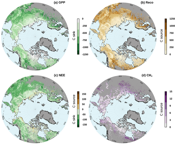
Gridded CO2 and CH4 Flux Estimates for pan-Arctic and Boreal Regions, 2003-2015
National Aeronautics and Space Administration —
This dataset provides gridded estimates of gross primary productivity (GPP), ecosystem respiration (Reco), net ecosystem CO2 exchange (NEE = Reco - GPP), and methane... -
Federal
Ground temperatures, Liefdefjord, northwest Svalbard, Version 1
National Aeronautics and Space Administration —
This dataset includes ground temperature data from coarse morainal (till) soil in a tundra area, on a 2-degree slope with rapid drainage, 45 m asl, at an undisturbed... -
Federal
ClimoBase: Rouse Canadian Surface Observations of Weather, Climate, and Hydrological Variables, 1984-1998, Version 1
National Aeronautics and Space Administration —
ClimoBase is a collection of surface climate measurements collected in Northern Canada by Dr. Wayne Rouse between 1984 and 1998 in three locations: Churchill,... -
Federal
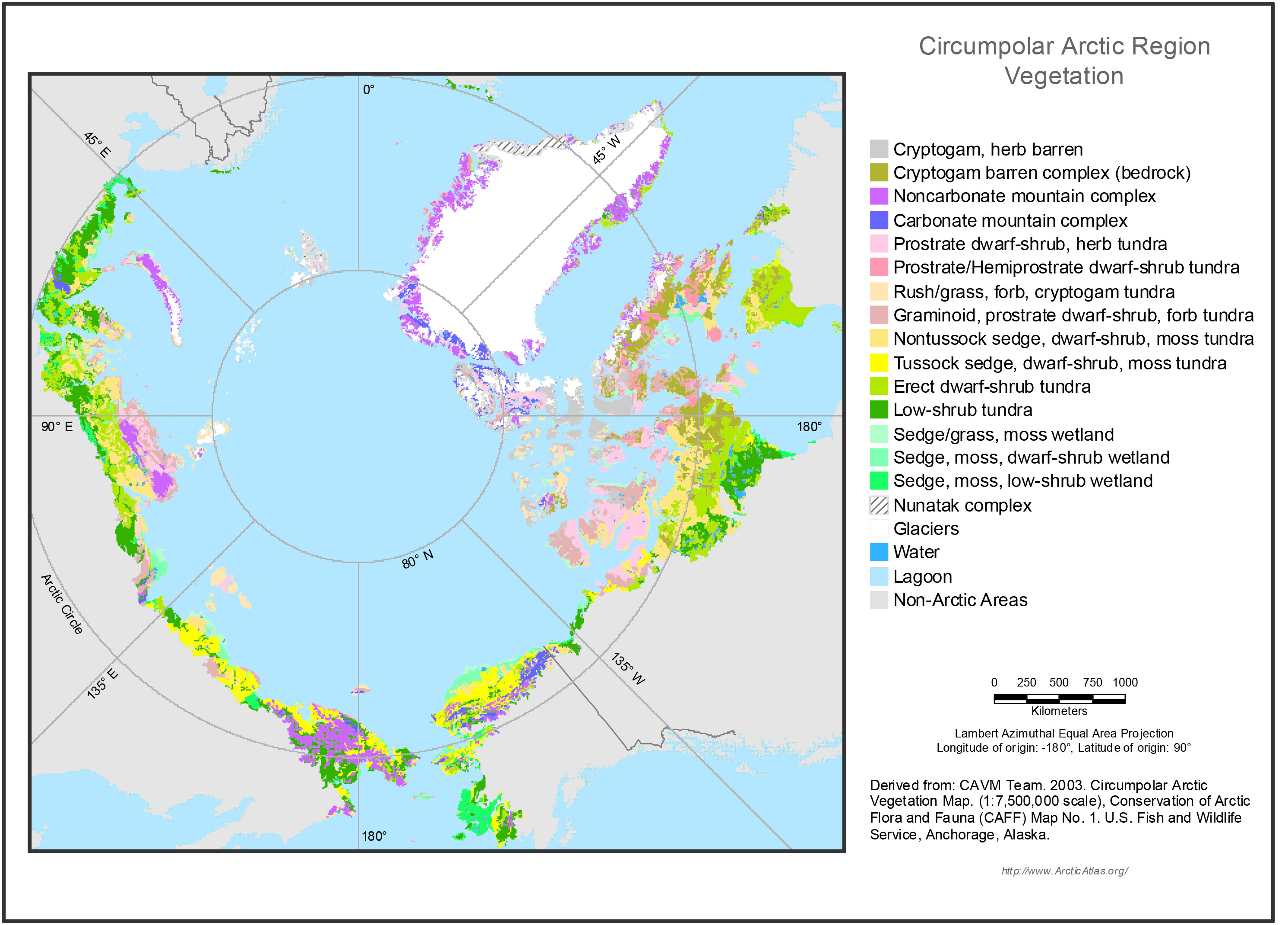
Circumpolar Arctic Vegetation, Geobotanical, Physiographic Maps, 1982-2003
National Aeronautics and Space Administration —
This data set provides the spatial distributions of vegetation types, geobotanical characteristics, and physiographic features for the circumpolar Arctic tundra biome... -
Federal
CAR LEADEX Arctic Sea Ice and Tundra Radiation Measurements L1 V1 (CAR_LEADEX_L1C) at GES DISC
National Aeronautics and Space Administration —
CAR LEADEX mission measured bidirectional reflectance functions for four common arctic surfaces: snow covered sea ice, melt season sea ice, snow covered tundra, and...

Official websites use .gov
A
.gov website belongs to an official government
organization in the United States.
Secure .gov websites use HTTPS
A
lock (
) or https:// means you’ve safely connected to
the .gov website. Share sensitive information only on official,
secure websites.