
-
Federal
NOAA ESRI Grid - predictions of seabird species richness in the New York offshore planning area made by the NOAA Biogeography Branch
National Oceanic and Atmospheric Administration, Department of Commerce —
This dataset represents seabird species richness, or number of species, predictions from spatial models developed for the New York offshore spatial planning area.... -
Federal
2014 Lee County, GA DMC 4-Band 8 Bit Imagery
National Oceanic and Atmospheric Administration, Department of Commerce —
This data set consists of six-inch pixel resolution, natural color orthoimages covering the urban area footprint. An orthoimage is remotely sensed image data in which... -
Federal
2014 City of Cairo, GA DMC 4-Band 8 Bit Imagery
National Oceanic and Atmospheric Administration, Department of Commerce —
This data set consists of six-inch pixel resolution, natural color orthoimages covering the urban area footprint. An orthoimage is remotely sensed image data in which... -
Federal
NOAA ESRI Grid - seafloor hardbottom occurrence predictions model in New York offshore planning area from Biogeography Branch
National Oceanic and Atmospheric Administration, Department of Commerce —
This dataset represents hard bottom occurrence predictions from a spatial model developed for the New York offshore spatial planning area. This model builds upon the... -
Federal
2019 Eureka, CA UltraCam 4-Band 8 Bit Imagery
National Oceanic and Atmospheric Administration, Department of Commerce —
This orthophotography dataset was created for the City of Eureka, California as a seamless 1.5-inch pixel resolution orthorectified aerial imagery dataset covering... -
Federal
EAARL-B Submerged Topography - Saint Croix and Saint Thomas, U.S. Virgin Islands, 2014
National Oceanic and Atmospheric Administration, Department of Commerce —
Binary point-cloud data for part of the submerged environs of Saint Croix and Saint Thomas, U.S. Virgin Islands, were produced from remotely sensed, geographically... -
Federal
2016 Morgan County, Georgia ADS100 4-Band 8 Bit Imagery
National Oceanic and Atmospheric Administration, Department of Commerce —
This data set consists of 0.5-foot pixel resolution, natural color orthoimages covering Morgan County, Georgia. An orthoimage is remotely sensed image data in which... -
Federal
2016 Walton County, Georgia ADS100 4-Band 8 Bit Imagery
National Oceanic and Atmospheric Administration, Department of Commerce —
This data set consists of 0.5-foot pixel resolution, natural color orthoimages covering Walton County, Georgia. An orthoimage is remotely sensed image data in which... -
Federal
Imagery data for the Vegetation Mapping Inventory Project of Oregon Caves National Monument
Department of the Interior —
This reference contains the imagery data used in the completion of the baseline vegetation inventory project for the NPS park unit. Orthophotos, raw imagery, and... -
Federal
EGS Collab: Modeling and Simulation Working Group Teleconference Series (99-128)
Department of Energy —
This submission contains the presentation slides and recordings from EGS Collab Modeling and Simulation Working Group (MSWG) teleconferences number 99 through 128.... -
Federal
Imagery data for the Vegetation Mapping Inventory Project of Buck Island Reef National Monument
Department of the Interior —
This reference contains the imagery data used in the completion of the baseline vegetation inventory project for the NPS park unit. Orthophotos, raw imagery, and... -
Federal
Thermal-Hydrological-Mechanical Modelling of Stockton University Reservoir Cooling System, Fine Scale Stress Test Modelling
Department of Energy —
Mesh, properties, initial conditions, injection/withdrawal rates for modelling thermal, hydrological, and mechanical effects of fluid injection to and withdrawal from... -
Federal
2016 Oconee County, Georgia ADS100 4-Band 8 Bit Imagery
National Oceanic and Atmospheric Administration, Department of Commerce —
This data set consists of 0.5-foot pixel resolution, natural color orthoimages covering Oconee County, Georgia. An orthoimage is remotely sensed image data in which... -
Federal
2012 Georgia Department of Natural Resources (DNR) Lidar: Baldwin, Hancock, Morgan, and Putnam Counties
National Oceanic and Atmospheric Administration, Department of Commerce —
LiDAR data is a remotely sensed high resolution elevation data collected by an airborne platform. The LiDAR sensor uses a combination of laser range finding, GPS... -
Federal
2014 City of Camilla, GA DMC 4-Band 8 Bit Imagery
National Oceanic and Atmospheric Administration, Department of Commerce —
This data set consists of six-inch pixel resolution, natural color orthoimages covering the urban area footprint. An orthoimage is remotely sensed image data in which... -
Federal
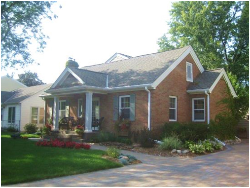
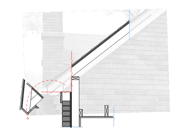
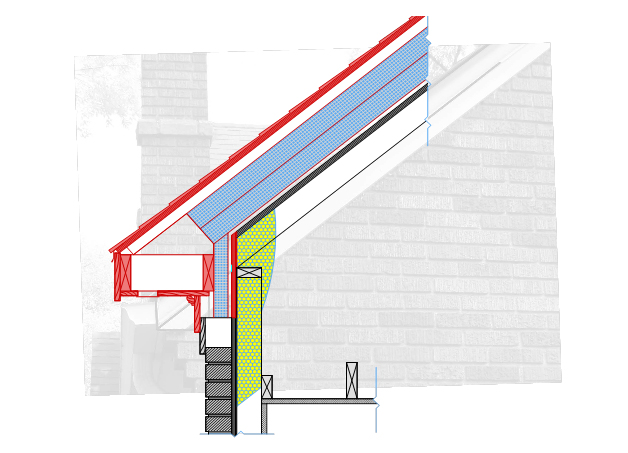
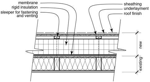
NorthernSTAR Project Overcoat: Exterior Insulation Strategies for 1.5-Story Roof Applications in Cold Climates
Department of Energy —
This is a repository for all NorthernSTAR Overcoat insulation retrofit projects. Both houses received Overcoat insulation retrofit on roof only, performed by Cocoon... -
Federal
NOAA NCCOS Assessment: Prioritizing Areas for Future Seafloor Mapping, Research, and Exploration on the Southeast U.S. Atlantic Coast (GA, SC, and NC) and Outer Continental Shelf from 2020-02-01 to 2020-05-01
National Oceanic and Atmospheric Administration, Department of Commerce —
Spatial information on the arrangement of geological features, habitats and living marine resources on the seabed are often the foundation for decision-making in... -
Federal
2014 Schley County, GA DMC 4-Band 8 Bit Imagery
National Oceanic and Atmospheric Administration, Department of Commerce —
This data set consists of six-inch pixel resolution, natural color orthoimages covering the urban area footprint. An orthoimage is remotely sensed image data in which... -
Federal
AirMSPI version 6 ellipsoid-projected georegistered radiance product acquired during the CalWater-2 flight campaign Jan-Feb 2015
National Aeronautics and Space Administration —
AirMSPI_CalWater-2_Ellipsoid-projected_Georegistered_Radiance_Data are AirMSPI Ellipsoid-projected georegistered radiance product acquired during the Precipitation,... -
Federal
2011 Georgia Department of Natural Resources (GADNR) Environmental Protection Division (EPD) Lidar: Four Counties (Burke, Columbia, Lincoln, and Richmond)
National Oceanic and Atmospheric Administration, Department of Commerce —
This data set is the topographic elevation point data derived from multiple return light detection and ranging (LiDAR) measurements for four counties in Georgia....

Official websites use .gov
A
.gov website belongs to an official government
organization in the United States.
Secure .gov websites use HTTPS
A
lock (
) or https:// means you’ve safely connected to
the .gov website. Share sensitive information only on official,
secure websites.