
-
Federal
NPP Temperate Forest: Great Smoky Mountains, Tennessee, USA, 1968-1992, R1
National Aeronautics and Space Administration —
This data set contains two data files (.csv format). One file contains site characteristics, stand descriptors, and above-ground biomass and ANPP data for seven old-... -
Federal
StarswithRotationPeriods&X-RayLuminositiesCatalog
National Aeronautics and Space Administration —
This table contains photometric and derived stellar parameters for a sample of 820 solar and late-type stars (the original table of 824 entries had 4 near-duplicate... -
Federal
GLAS/ICESat 1 km Laser Altimetry Digital Elevation Model of Greenland, Version 1
National Aeronautics and Space Administration —
The Geoscience Laser Altimeter System (GLAS) instrument on the Ice, Cloud, and land Elevation Satellite (ICESat) provides global measurements of elevation, and... -
Federal
Changes in Landscape Greenness and Climatic Factors over 25 Years (1989–2013) in the USA
U.S. Environmental Protection Agency —
The asci files are the probability of the NDVI trend (slope) and the direction of the NDVI trend (+/-). These files can be mapped in ArcMap using ArcToolbox... -
Federal
XMM-COSMOS Catalog of X-Ray Selected Type 1 AGN
National Aeronautics and Space Administration —
This table contains the results from a study of the X-ray to optical properties of a sample of 545 X-ray selected Type 1 AGN, from the XMM-Newton Cosmic Evolution... -
Federal
CARVE: L1 In-situ Carbon and CH4 Flux and Meteorology at EC Towers, Alaska, 2011-2015
National Aeronautics and Space Administration —
This data set provides ground in situ flux and meteorological science data from fixed instruments at three eddy covariance tower sites located in the Alaskan Arctic... -
Federal
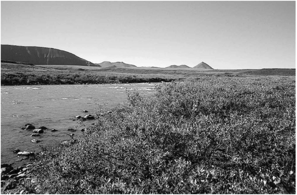
Arctic Vegetation Plots in Willow Communities, North Slope, Alaska, 1997
National Aeronautics and Space Administration —
This data set provides environmental, soil, and vegetation data collected in July and August 1997 from 85 study plots in willow shrub communities located along a... -
Federal
Atacama Cosmology Telescope 2008 Southern Survey 148/218 GHz Source Catalog
National Aeronautics and Space Administration —
This table contains a catalog of 191 extragalactic sources detected by the Atacama Cosmology Telescope (ACT) at 148 and/or 218 GHz in the 2008 Southern survey. Flux... -
Federal
NGC 4636 Chandra X-Ray Point Source Catalog
National Aeronautics and Space Administration —
This catalog lists the X-ray point-source population in the nearby Virgo elliptical galaxy NGC 4636 from three Chandra X-ray observations. These observations,... -
Federal
Permafrost Temperature Data from a Deep Borehole Array on the Arctic Slope of Alaska, 1973 - 2014, Version 1
National Aeronautics and Space Administration —
These data consist of fully processed permafrost temperature data from borehole logs acquired by the U.S. Geological Survey (USGS) from the 24-element US Department... -
Federal
Rock glaciers in the Pyrenees, Spain and France, Version 1
National Aeronautics and Space Administration —
This study and inventory of active rock glaciers was carried out by means of the usual techniques used in the study of alpine permafrost. First, the rock glaciers... -
Federal
Maps of Vegetation, NDVI, Snow and Thaw Depths: North Slope, Alaska and NWT, Canada
National Aeronautics and Space Administration —
This dataset includes vegetation cover maps, Normalized Difference Vegetation Index (NDVI) maps, snow depth and thaw depth data that were obtained as part of a... -
Federal
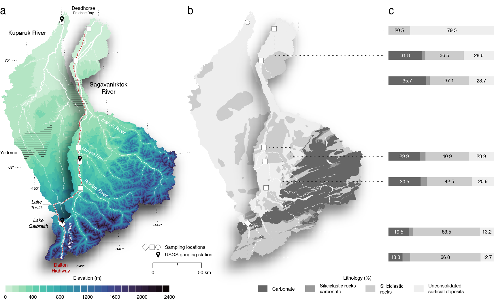
ABoVE: Seasonal Dissolved Gases and Isotopes in Arctic Alaska Rivers
National Aeronautics and Space Administration —
This dataset provides dissolved carbon dioxide (CO2) and methane (CH4) concentrations alongside their stable and radiocarbon isotopic compositions within the Arctic... -
Federal
ISLSCP II HYDRO1k Elevation-derived Products
National Aeronautics and Space Administration —
This data set contains coarse scale elevation and elevation-based parameters at 1.0 and 0.5-degree spatial resolutions that were developed to support a wide variety... -
Federal
CYGNSS Level 3 Climate Data Record Version 1.2
National Aeronautics and Space Administration —
This dataset contains the Version 1.2 CYGNSS Level 3 Climate Data Record which provides the average wind speed and mean square slope (MSS) on a 0.2x0.2 degree... -
Federal
Optimal Transmit Volume Conditions for MCV QoE Measurement Systems Software
Department of Commerce —
Software to perform audio device characterization using transmit volume optimization (TVO) of push-to-talk communication devices performing Mission Critical Voice... -
Federal
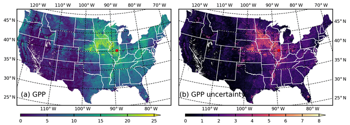
MODIS-based GPP, PAR, fC4, and SANIRv estimates from SLOPE for CONUS, 2000-2019
National Aeronautics and Space Administration —
This dataset contains estimated gross primary productivity (GPP), photosynthetically active radiation (PAR), soil adjusted near infrared reflectance of vegetation... -
Federal
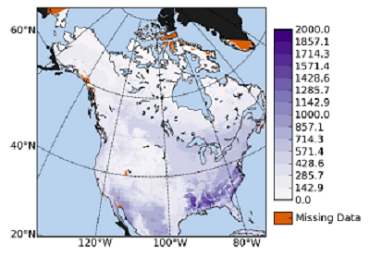
NACP VPRM NEE Parameters Optimized to North American Flux Tower Sites, 2000-2006
National Aeronautics and Space Administration —
This data set provides Vegetation Photosynthesis Respiration Model (VPRM) net ecosystem exchange (NEE) parameter values optimized to 65 flux tower sites across North... -
Federal
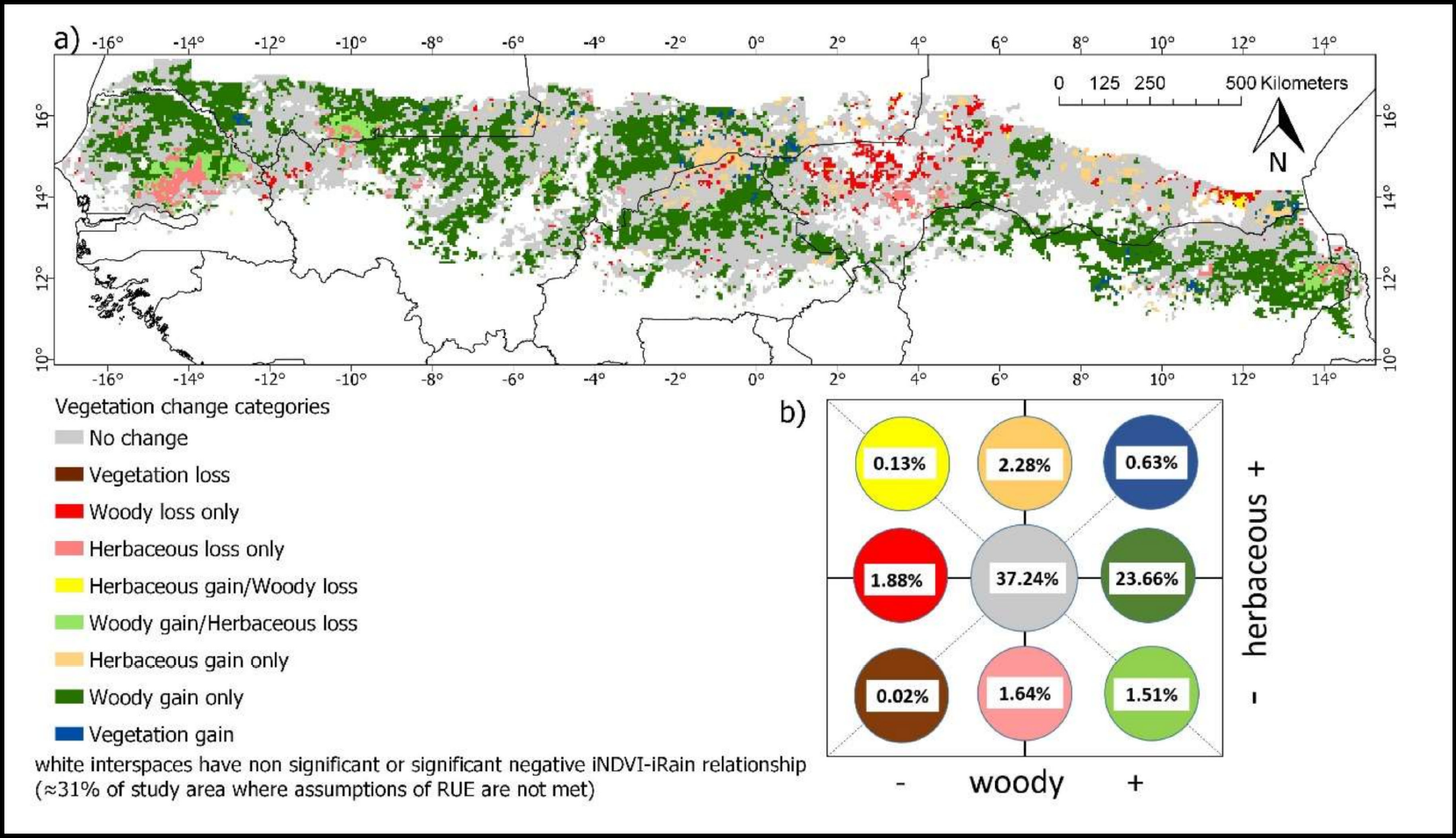
Woody and Herbaceous Vegetation Change across the Savannas of West Africa, 1982-2013
National Aeronautics and Space Administration —
The WAVeTrends dataset is a 0.05 degree (5.55 km) vegetation change product, spanning the West African Sudano-Sahel region. It provides pixel-wise information on...

Official websites use .gov
A
.gov website belongs to an official government
organization in the United States.
Secure .gov websites use HTTPS
A
lock (
) or https:// means you’ve safely connected to
the .gov website. Share sensitive information only on official,
secure websites.