
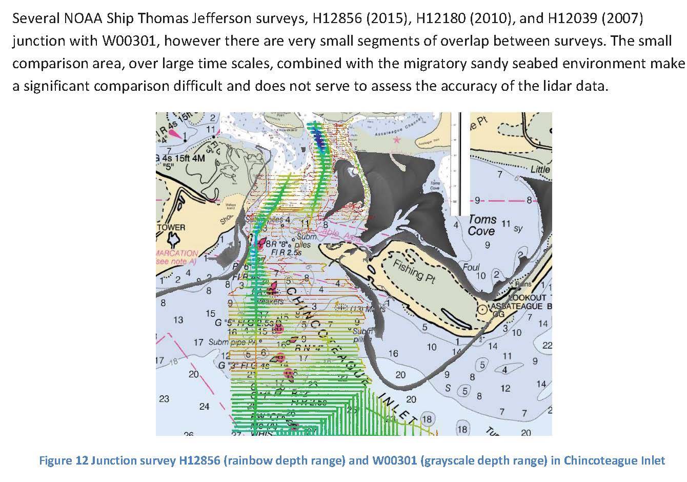
-
Federal
Juneau, Alaska 8/15 arc-second MHHW Coastal Digital Elevation Model
National Oceanic and Atmospheric Administration, Department of Commerce —
NOAA's National Geophysical Data Center (NGDC) is building high-resolution digital elevation models (DEMs) to support individual coastal States as part of the... -
Federal
W00327: NOS Hydrographic Survey , 2014-07-01
National Oceanic and Atmospheric Administration, Department of Commerce —
The National Oceanic and Atmospheric Administration (NOAA) has the statutory mandate to collect hydrographic data in support of nautical chart compilation for safe... -
Federal
H3 StingRAY Final Design and Technical Report
Department of Energy —
The goal of this Project was to develop a standards-compliant, fabrication-ready design of Columbia Power Technologies' (C-Power) next-generation wave energy... -
Federal
H13929: NOS Hydrographic Survey , 2024-09-27
National Oceanic and Atmospheric Administration, Department of Commerce —
The National Oceanic and Atmospheric Administration (NOAA) has the statutory mandate to collect hydrographic data in support of nautical chart compilation for safe... -
Federal
Demand-Side Grid (dsgrid) Building Load Profiles using ResStock and ComStock v2021
Department of Energy —
This dataset contains simulated hourly end use load profiles of the residential and commercial building sector in the contiguous United States for every other year... -
Federal
VIIRS/NPP BRDF/Albedo Valid Observation Band M2 Daily L3 Global 30ArcSec CMG V001
National Aeronautics and Space Administration —
The VNP43D43 Version 1 data product was decommissioned on July 31, 2025. Users are encouraged to use theFederalH13214: NOS Hydrographic Survey , 2019-09-25
National Oceanic and Atmospheric Administration, Department of Commerce —
The National Oceanic and Atmospheric Administration (NOAA) has the statutory mandate to collect hydrographic data in support of nautical chart compilation for safe...FederalH11475: NOS Hydrographic Survey , Approaches to Atchafalaya River and Bay, Louisiana, 2005-08-25
National Oceanic and Atmospheric Administration, Department of Commerce —
The National Oceanic and Atmospheric Administration (NOAA) has the statutory mandate to collect hydrographic data in support of nautical chart compilation for safe...FederalH11014: NOS Hydrographic Survey , Portsmouth, New Hamsphire, 2000-11-08
National Oceanic and Atmospheric Administration, Department of Commerce —
The National Oceanic and Atmospheric Administration (NOAA) has the statutory mandate to collect hydrographic data in support of nautical chart compilation for safe...FederalH11873: NOS Hydrographic Survey , Mid-Atlantic Corridor, Maryland, 2008-12-18
National Oceanic and Atmospheric Administration, Department of Commerce —
The National Oceanic and Atmospheric Administration (NOAA) has the statutory mandate to collect hydrographic data in support of nautical chart compilation for safe...FederalMODIS/Terra+Aqua Land Cover Type Yearly L3 Global 500m SIN Grid V061
National Aeronautics and Space Administration —
The Terra and Aqua combined Moderate Resolution Imaging Spectroradiometer (MODIS) Land Cover Type (MCD12Q1) Version 6.1 data product provides global land cover types...FederalVIIRS/NPP BRDF/Albedo Parameter 1 Band M7 Daily L3 Global 30 ArcSec CMG V001
National Aeronautics and Space Administration —
The VNP43D16 Version 1 data product was decommissioned on July 31, 2025. Users are encouraged to use theFederalVIIRS/NPP BRDF/Albedo WSA at Solar Noon NIR Daily L3 Global 30ArcSec CMG V001
National Aeronautics and Space Administration —
The VNP43D77 Version 1 data product was decommissioned on July 31, 2025. Users are encouraged to use theFederalCoastal Relief Models (CRMs)
National Oceanic and Atmospheric Administration, Department of Commerce —
Coastal Relief Models CRMs provide seamless topographic and bathymetric bare-earth elevation profiles of coastal regions for US states and territories. Extents span...FederalW00684: NOS Hydrographic Survey , External Source Data 2023, 2022-11-17
National Oceanic and Atmospheric Administration, Department of Commerce —
The National Oceanic and Atmospheric Administration (NOAA) has the statutory mandate to collect hydrographic data in support of nautical chart compilation for safe...FederalMODIS/Terra+Aqua BRDF/Albedo Black Sky Albedo Band7 Daily L3 Global 30ArcSec CMG V061
National Aeronautics and Space Administration —
The MCD43D48 Version 6.1 Bidirectional Reflectance Distribution Function and Albedo (BRDF/Albedo) Black-Sky Albedo dataset is produced daily using 16 days of Terra...FederalF00814: NOS Hydrographic Survey , 2020-09-03
National Oceanic and Atmospheric Administration, Department of Commerce —
The National Oceanic and Atmospheric Administration (NOAA) has the statutory mandate to collect hydrographic data in support of nautical chart compilation for safe...FederalWhittier, Alaska 8/15 arc-second MHHW Coastal Digital Elevation Model
National Oceanic and Atmospheric Administration, Department of Commerce —
NOAA's National Geophysical Data Center (NGDC) is building high-resolution digital elevation models (DEMs) to support individual coastal States as part of the...FederalMODIS/Terra Vegetation Indices Monthly L3 Global 0.05Deg CMG V061
National Aeronautics and Space Administration —
The Terra Moderate Resolution Imaging Spectroradiometer (MODIS) Vegetation Indices Monthly (MOD13C2) Version 6.1 product provides a Vegetation Index (VI) value at a...FederalMODIS/Terra Surface Reflectance 8-Day L3 Global 250m SIN Grid V061
National Aeronautics and Space Administration —
The MOD09Q1 Version 6.1 product provides an estimate of the surface spectral reflectance of Terra Moderate Resolution Imaging Spectroradiometer (MODIS) Bands 1 and 2,...3,752 datasets found for "Reference Grids"

Official websites use .gov
A
.gov website belongs to an official government
organization in the United States.
Secure .gov websites use HTTPS
A
lock (
) or https:// means you’ve safely connected to
the .gov website. Share sensitive information only on official,
secure websites.