

595 datasets found for "Rainfall"
-
City
SPU DWW Swales
City of Seattle —
The DWW (Drainage and Waste Water) GSI (Green Stormwater Infrastructure) layer consists of line and polygon representations of the following features: Swales... -
Federal
TRMM Precipitation Radar Rain Characteristics L2 1.5 hours V7 (TRMM_2A23) at GES DISC
National Aeronautics and Space Administration —
The new version of these data is in GPM-like format (consistent with the GPM Dual-frequency Radar data format), and can be found under the name GPM_2APR. The TRMM... -
Federal
CERES and GEO-Enhanced TOA, Within-Atmosphere and Surface Fluxes, Clouds and Aerosols Monthly-Averaged 1-Hourly Terra-NPP Edition1A
National Aeronautics and Space Administration —
CER_SYN1deg-MHour_Terra-NPP_Edition1A is the Clouds and the Earth's Radiant Energy System (CERES) and geostationary (GEO)-Enhanced Top-of-Atmosphere (TOA), Within-... -
Federal
CERES and GEO-Enhanced TOA, Within-Atmosphere and Surface Fluxes, Clouds and Aerosols 1-Hourly Terra-Aqua Edition4A
National Aeronautics and Space Administration —
CER_SYN1deg-1Hour_Terra-Aqua-MODIS_Edition4A is the Clouds and the Earth's Radiant Energy System (CERES) and geostationary (GEO) Top-of-Atmosphere (TOA) Within-... -
Federal
CERES and GEO-Enhanced TOA, Within-Atmosphere and Surface Fluxes, Clouds and Aerosols Monthly Terra-NOAA20 Edition4A
National Aeronautics and Space Administration —
CER_SYN1deg-Month_Terra-NOAA20_Edition4A is the Clouds and the Earth's Radiant Energy System (CERES) and geostationary (GEO)-Enhanced Top of Atmosphere (TOA), Within-... -
Federal
LBA-ECO CD-06 Water Balance of the Ji-Parana River Basin, Brazil: 1995-1996
National Aeronautics and Space Administration —
This data set provides simulated minimum, average, and maximum monthly rainfall, potential evapotranspiration, water deficit, and water surplus values for the Ji-... -
Federal
Jornada Basin LTER Cross-scale Interactions Study (CSIS) Block 2 meteorological station: 1-second summary precipitation data: 2017 - ongoing
Department of Agriculture —
1-second summary precipitation data at CSIS Block-2 met station. Total precipitation per second is recorded only if there is measurable precipitation. This is... -
Combined Sewer Outfall Sewer Shed
District of Columbia —
DC Water operates a wastewater collection system comprised of "separate" and "combined" sewers. Approximately two-thirds of the District is served by a separate sewer... -
Federal
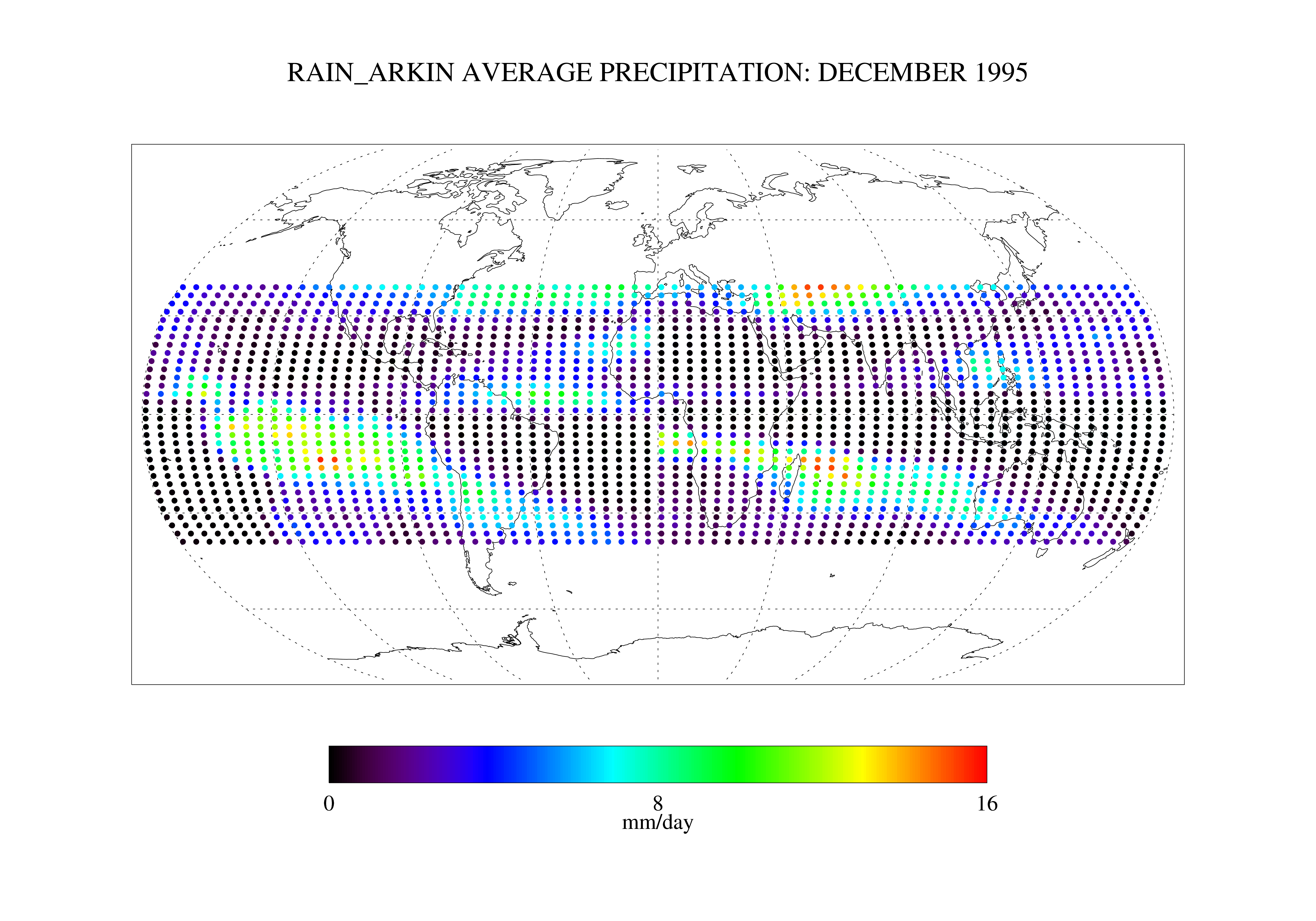
Arkin and Janowiak GPI: IR -Based Monthly Rainfall for the GPCP 2.5 x 2.5 degree V1 (RAIN_ARKIN) at GES DISC
National Aeronautics and Space Administration —
These data are transitioned to a state of permanent preservation. They are available upon request. More advanced datasets have been developed since. One recommended... -
State
Subregional Drainage Basin Set
State of Connecticut —
See full Data Guide here.Subregional Drainage Basic Set: Connecticut Subregional Drainage Basins is 1:24,000-scale, polygon and line feature data that define... -
Federal
R-Factor for the Island of Oahu
National Oceanic and Atmospheric Administration, Department of Commerce —
The rainfall-runoff erosivity factor (R-Factor) quantifies the effects of raindrop impacts and reflects the amount and rate of runoff associated with the rain. The... -
Federal
Jornada Basin LTER: Wireless meteorological station at NPP T-WEST site: 1-second summary precipitation data: 2013 - ongoing
Department of Agriculture —
1-second summary precipitation data at NPP T-WEST met station. Total precipitation per second is recorded only if there is measurable precipitation. This is recorded... -
Federal
Jornada Basin LTER: Wireless meteorological station at NPP P-COLL site: 1-second summary precipitation data: 2013 - ongoing
Department of Agriculture —
1-second summary precipitation data at NPP P-COLL met station. Total precipitation per second is recorded only if there is measurable precipitation. This is recorded... -
Federal
CERES and GEO-Enhanced TOA, Within-Atmosphere and Surface Fluxes, Clouds and Aerosols Monthly-Averaged 1-Hourly Terra-Aqua Edition4A
National Aeronautics and Space Administration —
CER_SYN1deg-MHour_Terra-Aqua-MODIS_Edition4A is the Clouds and the Earth's Radiant Energy System (CERES) and geostationary (GEO)-Enhanced Top-of-Atmosphere (TOA),... -
Federal
CERES Energy Balanced and Filled (EBAF) TOA and Surface Monthly means data in netCDF Edition 4.2.1
National Aeronautics and Space Administration —
CERES_EBAF_Edition4.2.1 is the Clouds and the Earth's Radiant Energy System (CERES) Energy Balanced and Filled (EBAF) Top-of-Atmosphere (TOA) and surface monthly... -
Federal
Jornada Basin LTER: Wireless meteorological station at NPP T-WEST site: Daily summary data: 2013 - ongoing
Department of Agriculture —
Daily summary data at NPP T-WEST met station. Average/maximum/minimum air temperature; average/maximum relative humidity and wind speed and average wind direction....
595 datasets found for "Rainfall"