
-
Federal
Coastal Bend Texas Benthic Habitat - Lower Laguna Madre 2004 Biotic
National Oceanic and Atmospheric Administration, Department of Commerce —
In 2006 and 2007 the NOAA Office for Coastal Management purchased services to process existing digital multi-spectral imagery (ADS-40) and create digital benthic... -
Federal
2002 Sediment Grab Data for Catlett and Goodwin Islands on the York River, Chesapeake Bay, Virginia (Ches_2002sedgrabs)
National Oceanic and Atmospheric Administration, Department of Commerce —
This data set represents the sediment grain size gathered from grab sampling in 2002 (56 stations).In Fall/Winter 2002, researchers from the Virginia Institute of... -
Federal
Benthic Habitats and Surficial Geology of Apalachicola Bay, Florida 2006 Biotic
National Oceanic and Atmospheric Administration, Department of Commerce —
These data were collected under a cooperative mapping program between the U.S. Geological Survey (USGS), the National Oceanic and Atmospheric Administration Office... -
Federal
Sediment grab data from October 1995 in the inland bays of New York/New Jersey Harbor
National Oceanic and Atmospheric Administration, Department of Commerce —
Sediment grab samples were collected using a Shipek grab at pre-determined locations in the harbor. Grain size distributions and organic content were measured and... -
Federal
Sediment profile image data from October 1994 in Lower Bay of New York/New Jersey Harbor
National Oceanic and Atmospheric Administration, Department of Commerce —
Sediment profile images (SPI) of the sediment-water interface were collected using a sediment profiling camera at pre-determined locations in the harbor. Physical,... -
Federal
Coastal Bend Texas Benthic Habitat Mapping Copano Bay 2004 Geoform
National Oceanic and Atmospheric Administration, Department of Commerce —
In 2006 and 2007 the NOAA Office for Coastal Management purchased services to process existing digital multi-spectral imagery (ADS-40) and create digital benthic... -
Federal
Vallisneria 2003-2004
National Oceanic and Atmospheric Administration, Department of Commerce —
We compared nekton use of Vallisneria americana Michx. (submerged aquatic vegetation, SAV) with marsh shoreline vegetation and subtidal nonvegetated bottom (SNB)... -
Federal
Coastal Bend Texas Benthic Habitat - San Antonio Bay 2007 Biotic
National Oceanic and Atmospheric Administration, Department of Commerce —
In 2006 and 2007 the NOAA Office for Coastal Management purchased services to process existing digital multi-spectral imagery (ADS-40) and create digital benthic... -
Federal
Coastal Bend Texas Benthic Habitat Mapping Aransas Bay 2004 Geodatabase
National Oceanic and Atmospheric Administration, Department of Commerce —
In 2006 and 2007 the NOAA Office for Coastal Management purchased services to process existing digital multi-spectral imagery (ADS-40) and create digital benthic... -
Federal
Coastal Massachusetts Submerged Aquatic Beds 1994-1996 Substrate
National Oceanic and Atmospheric Administration, Department of Commerce —
The Coastal Change Analysis Program (C-CAP) at NOAA Office for Coastal Management partnered with The Massachusetts Department of Environmental Protection Wetlands... -
Federal
Bathymetric ArcRaster Grid of Apalachicola Bay and St. George Sound, Florida (25m)
National Oceanic and Atmospheric Administration, Department of Commerce —
These data were collected under a cooperative mapping program between the U.S. Geological Survey (USGS), the National Oceanic and Atmospheric Administration Office... -
Federal
Simulating Hypoxia in Narragansett Bay
U.S. Environmental Protection Agency —
Data provided here include WASP input files and simulation outputs (Dissolved Oxygen (mg/l) and Phytoplankton (ug chl a/L). Simulation Outputs for base case year as... -
Federal
Benthic Habitat Mapping - Dry Tortugas RoxAnn Acoustic Sensor Data Points
National Oceanic and Atmospheric Administration, Department of Commerce —
During April 2001 RoxAnn single-beam acoustic surveys were conducted at the North Unit of the Tortugas Ecological Reserve, Florida. Thirteen transects associated with... -
State
Significant Lands - Waterbodies
State of California —
The State Lands Commission has prepared the Significant Lands Inventory (report) for the California Legislature as a general identification and classification of... -
State
i12 Salinity Contours
State of California —
Data represents maximum up-estuary intrusion of the 1 ppt salinity contour. The lines represent 1000 ppt chloride per million, measured 1½ hours after high tide. This... -
Federal
ASV_SEISMICSHOT500 - Shot Points at 500 Shot Intervals for Seismic Data Collected with Autonomous Surface Vehicle (ASV) IRIS in Apalachicola Bay and St. George Sound, FL.
National Oceanic and Atmospheric Administration, Department of Commerce —
These data were collected under a cooperative mapping program between the U.S. Geological Survey (USGS), the National Oceanic and Atmospheric Administration Office... -
Federal
San Francisco Bay Multi-beam Bathymetry: Area A
National Oceanic and Atmospheric Administration, Department of Commerce —
These multi-beam bathymetric data were collected over shallow subtidal areas in the San Francisco Bay estuary system. Bathymetric and acoustic backscatter data were... -
Federal
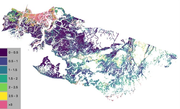
Delta-X: NUMAR Soil Accretion Modeled to 2100, MRD, Louisiana, USA
National Aeronautics and Space Administration —
This dataset holds modeled estimates of soil accretion for the Atchafalaya and Terrebonne basins in the Mississippi River Delta of coastal Louisiana, U.S. Soil... -
Federal
Coastal Massachusetts Submerged Aquatic Beds 1994-1996 Geodatabase
National Oceanic and Atmospheric Administration, Department of Commerce —
The Coastal Change Analysis Program (C-CAP) at NOAA Office for Coastal Management partnered with The Massachusetts Department of Environmental Protection Wetlands...

Official websites use .gov
A
.gov website belongs to an official government
organization in the United States.
Secure .gov websites use HTTPS
A
lock (
) or https:// means you’ve safely connected to
the .gov website. Share sensitive information only on official,
secure websites.