
-
Federal
2001-2003 IKONOS Imagery for Guam and the Commonwealth of the Northern Mariana Islands (CNMI) Utilized to Map Shallow Water Benthic Habitats
National Oceanic and Atmospheric Administration, Department of Commerce —
This project is a cooperative effort among the National Ocean Service, National Centers for Coastal Ocean Science, Center for Coastal Monitoring and Assessment; the... -
Federal
National Coral Reef Monitoring Program: Shallow Water and Offshore Conductivity-Temperature-Depth (CTD) Profiles for select coral reef locations across the Hawaiian Archipelago since 2013
National Oceanic and Atmospheric Administration, Department of Commerce —
Nearshore and offshore Conductivity-Temperature-Depth (CTD) casts were collected at sites in the Hawaiian Archipelago as part of the National Coral Reef Monitoring... -
Federal
Slope Grid Derived from Gridded Bathymetry for Select U.S. Coral Reef Locations across the Pacific Ocean
National Oceanic and Atmospheric Administration, Department of Commerce —
Slope is derived for islands and banks across the U.S. Pacific Islands Region primarily from gridded multibeam bathymetry collected aboard NOAA Ships Hi'ialakai and... -
Federal
National Coral Reef Monitoring Program: Assessment of coral reef fish communities in Puerto Rico from 2021-04-29 to 2021-12-24 (NCEI Accession 0276281)
National Oceanic and Atmospheric Administration, Department of Commerce —
The National Coral Reef Monitoring Program (NCRMP) assessed coral reef fish communities around Puerto Rico using the stationary point count method (7.5m radius... -
Federal
Report to Congress on Direct Commercial Sales Authorizations to Foreign Countries and International Organizations for Fiscal Year 2015
Department of State —
This report covers military assistance and military exports of defense articles and defense services licensed for permanent export to foreign country governments and... -
Federal
NOAA Cooperative Observer Program (COOP) Precipitation Data - Hourly, Version 2
National Oceanic and Atmospheric Administration, Department of Commerce —
The Cooperative Observer Program (COOP) Hourly Precipitation Data (HPD) consists of quality controlled precipitation amounts, which are measurements of hourly... -
Federal
Distributed Generation Market Demand (dGen) model
Department of Energy —
The Distributed Generation Market Demand (dGen) model simulates customer adoption of distributed energy resources (DERs) for residential, commercial, and industrial... -
Federal
Annual Land Use and Urban Land Cover: Ethiopia, Nigeria, and South Africa, 2016-2020
National Aeronautics and Space Administration —
This dataset provides a two-tier annual Land Use (LU) and Urban Land Cover (LC) product suite over three African countries, Ethiopia, Nigeria, and South Africa,... -
Federal
St. John, USVI Fish Assessment and Monitoring Data (2002 - Present)
National Oceanic and Atmospheric Administration, Department of Commerce —
This fish and benthic composition database is the result of a multifaceted effort described below.The intent of this work is five fold: 1) To spatially characterize... -
Federal
NOAA TIFF Image - 4m Bathymetric Slope of Slope for Red Snapper Research Areas in the South Atlantic Bight, 2010
National Oceanic and Atmospheric Administration, Department of Commerce —
This dataset contains unified Bathymetric Slope of Slope GeoTiffs with 4x4 meter cell resolution describing the topography of 15 areas along the shelf edge off the... -
Federal
Hawaii Coral Reef Assessment and Monitoring Program (CRAMP) benthic data and still images from 2018-06-13 to 2018-07-16 on Maui (NCEI Accession 0222175)
National Oceanic and Atmospheric Administration, Department of Commerce —
This dataset consists of digital still images along coral reef transect lines, from which quantitative benthic data are derived from select images via PhotoGrid, a... -
Federal
National Coral Reef Monitoring Program: Assessment of coral reef fish communities in the Florida Reef Tract
National Oceanic and Atmospheric Administration, Department of Commerce —
Coral reef fish survey data provided in this collection are from three (3) distinct regions along the Florida reef tract; 1) Dry Tortugas, 2) Florida Keys from Key... -
Federal
MASTER: Geological Earth Mapping Experiment (GEMx), Spring 2024
National Aeronautics and Space Administration —
This dataset includes Level 1B (L1B) data products from the MODIS/ASTER Airborne Simulator (MASTER) instrument. The spectral data were collected during 26 flights... -
Federal
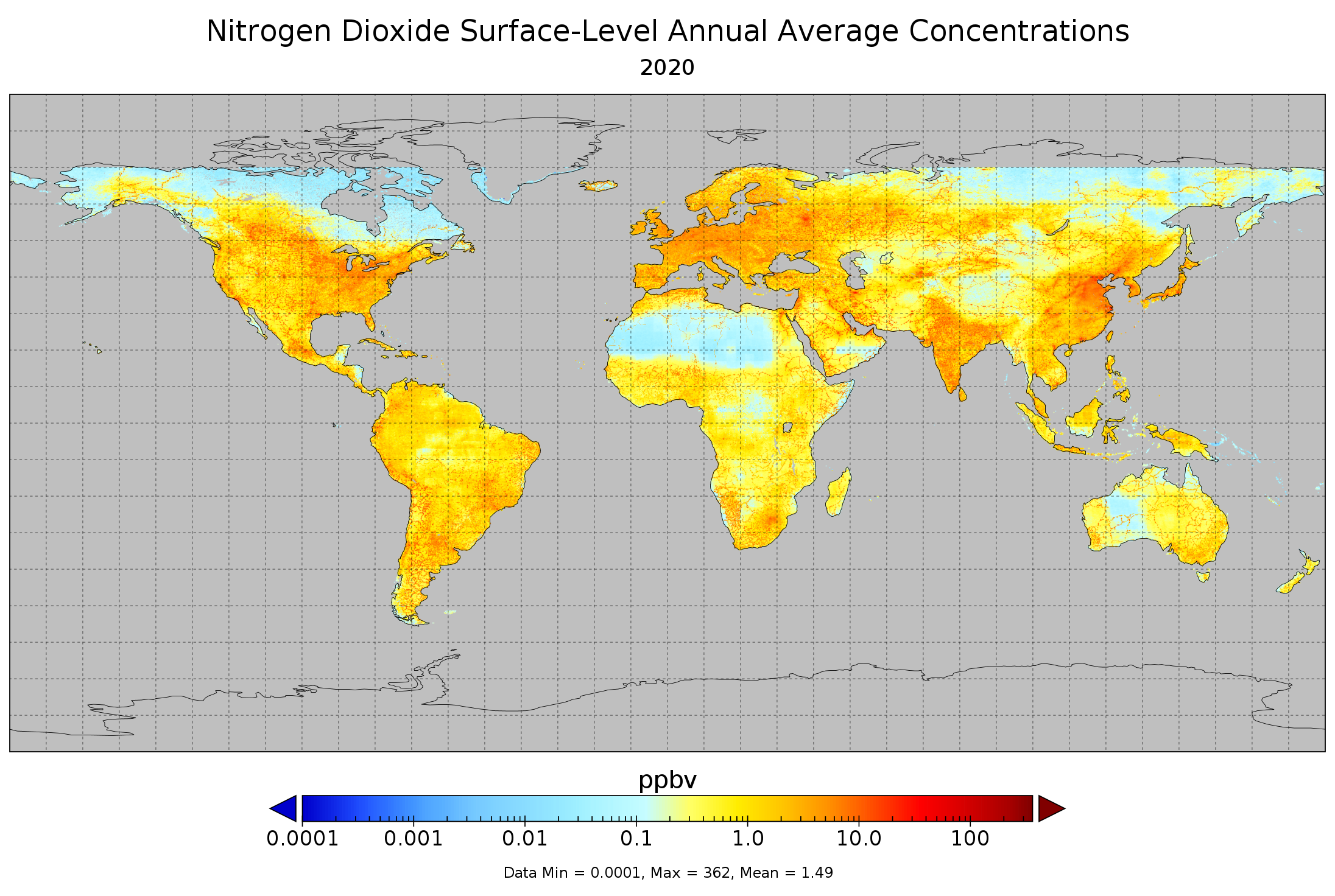
Nitrogen Dioxide Surface-Level Annual Average Concentrations V1 (SFC_NITROGEN_DIOXIDE_CONC) at GES DISC
National Aeronautics and Space Administration —
The Nitrogen Dioxide Surface-Level Annual Average Concentrations Product (SFC_NITROGEN_DIOXIDE_CONC) contains estimated global NO2 surface values derived using a Land... -
Federal
WIND Toolkit Long-Term Ensemble Dataset
Department of Energy —
WIND Toolkit Long-term Ensemble Dataset (WTK-LED), an updated version of the meteorological WIND Toolkit, is a meteorological dataset providing high-resolution time... -
Federal
Florida Keys National Marine Sanctuary Boundary (polygon)
National Oceanic and Atmospheric Administration, Department of Commerce —
The Office of National Marine Sanctuaries manages a system of sanctuaries and other managed areas around the country. The legal boundaries of These sanctuaries are... -
Federal
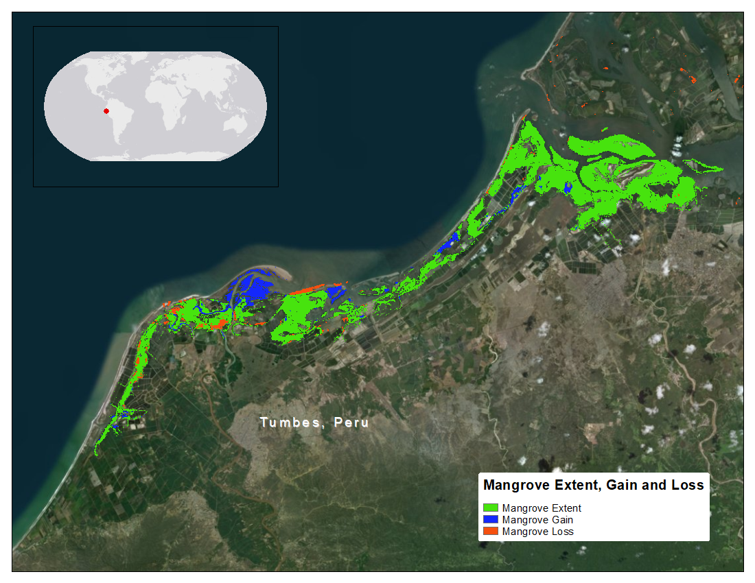
CMS: Mangrove Forest Cover Extent and Change across Major River Deltas, 2000-2016
National Aeronautics and Space Administration —
This dataset provides estimates of mangrove extent for 2016, and mangrove change (gain or loss) from 2000 to 2016, in major river delta regions of eight countries:... -
Federal
International Bathymetric Chart of the Arctic Ocean, Version 1.0
National Oceanic and Atmospheric Administration, Department of Commerce —
The goal of this initiative is to develop a digital data base that contains all available bathymetric data north of 64 degrees North, for use by mapmakers,... -
Federal
Global Historical Climatology Network - Monthly (GHCN-M), Version 3
National Oceanic and Atmospheric Administration, Department of Commerce —
Please note, GHCN-Monthly provides climatological observations for four elements; monthly mean maximum temperature, minimum temperature, mean temperature, and...

Official websites use .gov
A
.gov website belongs to an official government
organization in the United States.
Secure .gov websites use HTTPS
A
lock (
) or https:// means you’ve safely connected to
the .gov website. Share sensitive information only on official,
secure websites.