
-
Federal
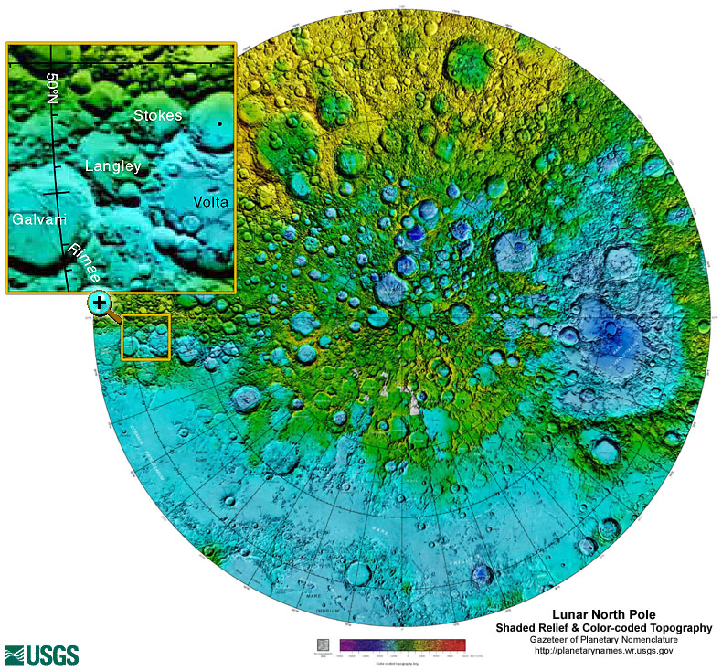
Gazetteer of Planetary Nomenclature: Moon: 1:10 million-scale Shaded Relief and Color-coded Topography: North Pole
National Aeronautics and Space Administration —
These lunar maps display the four different areas of the moon with color-coded topography in low and high resolution approved by the International Astronomical Union... -
Federal
2015 NOAA NGS Ortho-rectified Color Mosaic of Jacksonville, FL
National Oceanic and Atmospheric Administration, Department of Commerce —
This data set contains ortho-rectified mosaic tiles, created as a product from the NOAA Integrated Ocean and Coastal Mapping (IOCM) initiative. The source imagery was... -
Federal
JPSS-2 CrIS IMG_COL: Array indices for collocated VIIRS observations V3.0 (SNDRJ2CrISL1BIMGC) at GES DISC
National Aeronautics and Space Administration —
The Cross-track Infrared Sounder (CrIS) Level 1B Full Spectral Resolution (FSR) data files contain radiance measurements along with ancillary spacecraft, instrument,... -
Federal
Data from: Genotypic characterization of the U.S. peanut core collection
Department of Agriculture —
This collection contains supplementary data for the manuscript "Genotypic characterization of the U.S. Peanut Core Collection", which describes genotyping results for... -
Federal
Southeast Alaska 8/3 arc-second MHHW Coastal Digital Elevation Model
National Oceanic and Atmospheric Administration, Department of Commerce —
NOAA's National Geophysical Data Center (NGDC) is building high-resolution digital elevation models (DEMs) to support individual coastal States as part of the... -
Federal
San Diego, California 1/3 Arc-second MHW Coastal Digital Elevation Model
National Oceanic and Atmospheric Administration, Department of Commerce —
NOAA's National Geophysical Data Center (NGDC) is building high-resolution digital elevation models (DEMs) for select U.S. coastal regions. These integrated... -
Federal
2016 Oconee County, Georgia ADS100 4-Band 8 Bit Imagery
National Oceanic and Atmospheric Administration, Department of Commerce —
This data set consists of 0.5-foot pixel resolution, natural color orthoimages covering Oconee County, Georgia. An orthoimage is remotely sensed image data in which... -
Federal
2016 Walton County, Georgia ADS100 4-Band 8 Bit Imagery
National Oceanic and Atmospheric Administration, Department of Commerce —
This data set consists of 0.5-foot pixel resolution, natural color orthoimages covering Walton County, Georgia. An orthoimage is remotely sensed image data in which... -
Federal
2014 City of Sylvester, GA DMC 4-Band 8 Bit Imagery
National Oceanic and Atmospheric Administration, Department of Commerce —
This data set consists of six-inch pixel resolution, natural color orthoimages covering the urban area footprint. An orthoimage is remotely sensed image data in which... -
Federal
Northern Gulf 1 arc-second NAVD 88 Coastal Digital Elevation Model
National Oceanic and Atmospheric Administration, Department of Commerce —
NOAA's National Geophysical Data Center (NGDC) is building high-resolution digital elevation models (DEMs) for select U.S. coastal regions in the Gulf of Mexico.... -
Federal
Madison-Swanson MPA reef fish video survey
National Oceanic and Atmospheric Administration, Department of Commerce —
The Southeast Fisheries Science Center Mississippi Laboratories conducts standardized fisheries independent resource surveys in the Gulf of Mexico, South Atlantic,... -
Federal
National Coral Reef Monitoring Program: Benthic Images Collected from Climate Stations across the Hawaiian Archipelago since 2013
National Oceanic and Atmospheric Administration, Department of Commerce —
Photoquadrat benthic images were collected at NCRMP climate stations and permanent sites identified by the Ocean and Climate Change team across the Hawaiian... -
Federal
Biloxi, Mississippi Coastal Digital Elevation Model
National Oceanic and Atmospheric Administration, Department of Commerce —
NOAA's National Geophysical Data Center (NGDC) is building high-resolution digital elevation models (DEMs) for select U.S. coastal regions. These integrated... -
Federal
Monthly Composite Raster Images for Sea Surface Temperature in the Gulf of Maine for Stellwagen Bank NMS
National Oceanic and Atmospheric Administration, Department of Commerce —
This personal geodatabase contains raster images of sea surface temperature (SST) in the Gulf of Maine. These raster images are monthly composites, and were... -
Federal
Easter Island, Chile 3 arc-second Digital Elevation Model
National Oceanic and Atmospheric Administration, Department of Commerce —
NOAA's National Centers for Environmental Information is building high-resolution digital elevation models (DEMs) for select U.S. coastal regions. These integrated... -
Federal
Unalaska, Alaska 8/15 Arc-second MHHW Coastal Digital Elevation Model
National Oceanic and Atmospheric Administration, Department of Commerce —
NOAA's National Geophysical Data Center (NGDC) is building high-resolution digital elevation models (DEMs) to support individual coastal States as part of the... -
Federal
2005 Hurricane Katrina Response Imagery
National Oceanic and Atmospheric Administration, Department of Commerce —
This dataset is a single image tile from a collection of GeoTIFF format natural color image tiles that cover regions of Alabama, Louisiana, and Mississippi that were... -
Federal
Mariana Trench 6 arc-second Bathymetric Digital Elevation Model
National Oceanic and Atmospheric Administration, Department of Commerce —
NOAA's National Geophysical Data Center (NGDC) created a bathymetric digital elevation model (DEM) for the Mariana Trench and adjacent seafloor in the Western Pacific...

Official websites use .gov
A
.gov website belongs to an official government
organization in the United States.
Secure .gov websites use HTTPS
A
lock (
) or https:// means you’ve safely connected to
the .gov website. Share sensitive information only on official,
secure websites.