
-
Federal
NEPR Ground Validation Points 2015
National Oceanic and Atmospheric Administration, Department of Commerce —
This shapefile denotes the location of underwater photos and videos taken in shallow water (0-35m) benthic habitats surrounding Northeast Puerto Rico and Culebra... -
Federal
Ground Validation Drop Camera Transect Points - St. Thomas/ St. John USVI - 2011
National Oceanic and Atmospheric Administration, Department of Commerce —
This shapefile denotes the location of underwater video that was collected by NOAA scientists using a SeaViewer drop camera system. Video were collected between... -
Federal
Injury/Illness Summary - Casualty Source Data (Form 55A)
Department of Transportation —
Casualties are reportable fatalities, injuries, or illnesses arising from the operation of a railroad. Casualties may be classified as either fatal or nonfatal. All... -
Federal
NOAA Point Shapefile - ROV transects, US Caribbean - St. Thomas and St. John - Project NF-03-10-USVI - (2010), UTM 20N NAD83
National Oceanic and Atmospheric Administration, Department of Commerce —
This shapefile denotes the location of underwater photos and/or video that were collected by NOAA scientists using a Spectrum Phantom S2 ROV (remotely operated... -
Federal
NOAA Polyline Shapefile - ROV transects, US Caribbean - Western Puerto Rico - Project NF-08-04 - (2008), UTM 19N NAD83
National Oceanic and Atmospheric Administration, Department of Commerce —
This shapefile denotes the location of underwater photos and/or video that were collected by NOAA scientists using a Spectrum Phantom S2 ROV (remotely operated... -
State
Market Analysis by Agency
State of Oklahoma —
Market analysis of classified employees by agency for the previous fiscal year. This analysis shows the number of classified employees as well as benchmarks for the... -
Federal
Depth (Standard Deviation) Layer used to identify, delineate and classify moderate-depth benthic habitats around St. John, USVI
National Oceanic and Atmospheric Administration, Department of Commerce —
Standard deviation of depth was calculated from the bathymetry surface for each cell using the ArcGIS Spatial Analyst Focal Statistics "STD" parameter. Standard... -
Federal
Bathymetry Surface Layer used to identify, delineate and classify moderate-depth benthic habitats around St. John, USVI
National Oceanic and Atmospheric Administration, Department of Commerce —
This image represents a 2x2 meter resolution bathymetry surface of the moderate-depth portion of the NPS's Virgin Islands Coral Reef National Monument, south of St.... -
Federal
Consequences of a Criminal Record for Employment Opportunity in Milwaukee, Wisconsin, 2002
Department of Justice —
This study examined employers' policies and practices for hiring entry-level workers in the Milwaukee metropolitan area. The study consisted of telephone interviews... -
Federal
NOAA Point Shapefile - Drop Camera transects, US Caribbean - Virgin Passage and St. John Shelf - Project NF-03-10-USVI-HAB - (2010), UTM 20N NAD83
National Oceanic and Atmospheric Administration, Department of Commerce —
This shapefile denotes the location of underwater video that was collected by NOAA scientists using a SeaViewer drop camera system. For more information about this... -
Federal
Fall 2011 SAV Classification
National Oceanic and Atmospheric Administration, Department of Commerce —
The sub-aquatic vegitation map for was produced for the SAV Technical Working Group under a cooperative workplan with BP. The SAV map was derived from 0.3 meter... -
Federal
Marano Field XMM-Newton X-Ray Source Optical Counterparts
National Aeronautics and Space Administration —
This table contains some of the results from a medium deep XMM-Newton survey of the Marano Field and optical follow-up observations. The mosaicked XMM-Newton... -
Federal
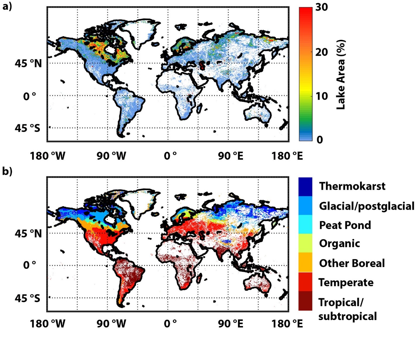
Global-Gridded Daily Methane Emissions Climatology from Lake Systems, 2003-2015
National Aeronautics and Space Administration —
This dataset provides global gridded information on lake surface area and open water CH4 emissions at a resolution of 0.25-degree x 0.25-degree for an annual... -
Federal
NOAA Polyline Shapefile - MiniBat transects, US Virgin Islands - St. John, St. Thomas and St. Croix - Project NF-04-06-VI - (2004), UTM 20N NAD83 (NCEI Accession 0131850)
National Oceanic and Atmospheric Administration, Department of Commerce —
This shapefile denotes the location of underwater photos and/or video that were collected by NOAA scientists using a MiniBat towed underwater system. Photos and/or... -
City
City Jobs Hiring Data
City of New Orleans —
This dataset reflects hire actions submitted to the Civil Service Department for classified positions. Hire actions include new employees hired since January of... -
State
Classified and Unclassified State Employees FY 1994-2013
State of Oklahoma —
Classified and Unclassified State Employees FY 1994-2013 -
Federal
Principal Components Analysis (PCA) Image used to characterize the complexity of the seafloor around St. John, USVI
National Oceanic and Atmospheric Administration, Department of Commerce —
Eight complexity surfaces (mean depth, standard deviation of depth, curvature, plan curvature, profile curvature, rugosity, slope, and slope of slope) were stacked... -
Federal
Small Business Profiles for the States and Territories - 2018
Small Business Administration —
The Office of Advocacy’s Small Business Profiles are an annual portrait of each state’s small business. They gather the latest federal data into state-by-state...

Official websites use .gov
A
.gov website belongs to an official government
organization in the United States.
Secure .gov websites use HTTPS
A
lock (
) or https:// means you’ve safely connected to
the .gov website. Share sensitive information only on official,
secure websites.