
-
Federal
L01100: NOS Hydrographic Survey , 1905-12-31
National Oceanic and Atmospheric Administration, Department of Commerce —
The National Oceanic and Atmospheric Administration (NOAA) has the statutory mandate to collect hydrographic data in support of nautical chart compilation for safe... -
Federal
NCCOS Assessment: Benthic Habitat Map for the Insular Shelf South of St. Thomas and St. John, U.S. Virgin Islands (NCEI Accession 0170098)
National Oceanic and Atmospheric Administration, Department of Commerce —
The dataset describes the spatial distribution of benthic habitats on the insular shelf south of St. Thomas and St. John, U.S. Virgin Islands. These benthic habitats... -
Federal
New Orleans, Louisiana 1/3 arc-second MHW Coastal Digital Elevation Model
National Oceanic and Atmospheric Administration, Department of Commerce —
NOAA's National Geophysical Data Center (NGDC) is building high-resolution digital elevation models (DEMs) for select U.S. coastal regions in the Gulf of Mexico.... -
Federal
Indian River (S190) Bathymetric Digital Elevation Model - NOAA/NOS Estuarine Bathymetry
National Oceanic and Atmospheric Administration, Department of Commerce —
A 1/3 arc-second Mean Lower Low Water bathymetric DEM of NOS hydrographic survey data in Indian River, FL. -
Federal
Adak, Alaska 1 arc-second Coastal Digital Elevation Model
National Oceanic and Atmospheric Administration, Department of Commerce —
NOAA's National Geophysical Data Center (NGDC) is building high-resolution digital elevation models (DEMs) for select U.S. coastal regions. These integrated... -
Federal
Sitka, Alaska 1/3 arc-second MHW Coastal Digital Elevation Model
National Oceanic and Atmospheric Administration, Department of Commerce —
NOAA's National Geophysical Data Center (NGDC) is building high-resolution digital elevation models (DEMs) for select U.S. coastal regions. These integrated... -
Federal
Bathymetry of Lake Erie and Lake Saint Clair
National Oceanic and Atmospheric Administration, Department of Commerce —
Bathymetry of Lake Erie and Lake Saint Clair has been compiled as a component of a NOAA project to rescue Great Lakes lake floor geological and geophysical data and... -
Federal
2-minute Gridded Global Relief Data (ETOPO2) v2
National Oceanic and Atmospheric Administration, Department of Commerce —
This version has been superseded by a newer version. It is highly recommended for users to access the current version. Users should only access this superseded... -
Federal
Bathymetry of Lake Ontario
National Oceanic and Atmospheric Administration, Department of Commerce —
Bathymetry of Lake Ontario has been compiled as a component of a NOAA project to rescue Great Lakes lake floor geological and geophysical data and make it more... -
Federal
NOAA's Hydrographic Surveys and Reports
National Oceanic and Atmospheric Administration, Department of Commerce —
The National Oceanic and Atmospheric Administration (NOAA) has the statutory mandate to collect hydrographic data to support the compilation of nautical charts and... -
Federal
Puerto Rico Coastal Digital Elevation Model
National Oceanic and Atmospheric Administration, Department of Commerce —
NOAA's National Geophysical Data Center (NGDC) is building high-resolution digital elevation models (DEMs) for select U.S. coastal regions. These integrated... -
Federal
F00082: NOS Hydrographic Survey , 1949-06-23
National Oceanic and Atmospheric Administration, Department of Commerce —
The National Oceanic and Atmospheric Administration (NOAA) has the statutory mandate to collect hydrographic data in support of nautical chart compilation for safe... -
Federal
H04271: NOS Hydrographic Survey , 1922-12-31
National Oceanic and Atmospheric Administration, Department of Commerce —
The National Oceanic and Atmospheric Administration (NOAA) has the statutory mandate to collect hydrographic data in support of nautical chart compilation for safe... -
Federal
F00473D: NOS Hydrographic Survey , San Diego Bay, California, 2001-04-13
National Oceanic and Atmospheric Administration, Department of Commerce —
The National Oceanic and Atmospheric Administration (NOAA) has the statutory mandate to collect hydrographic data in support of nautical chart compilation for safe... -
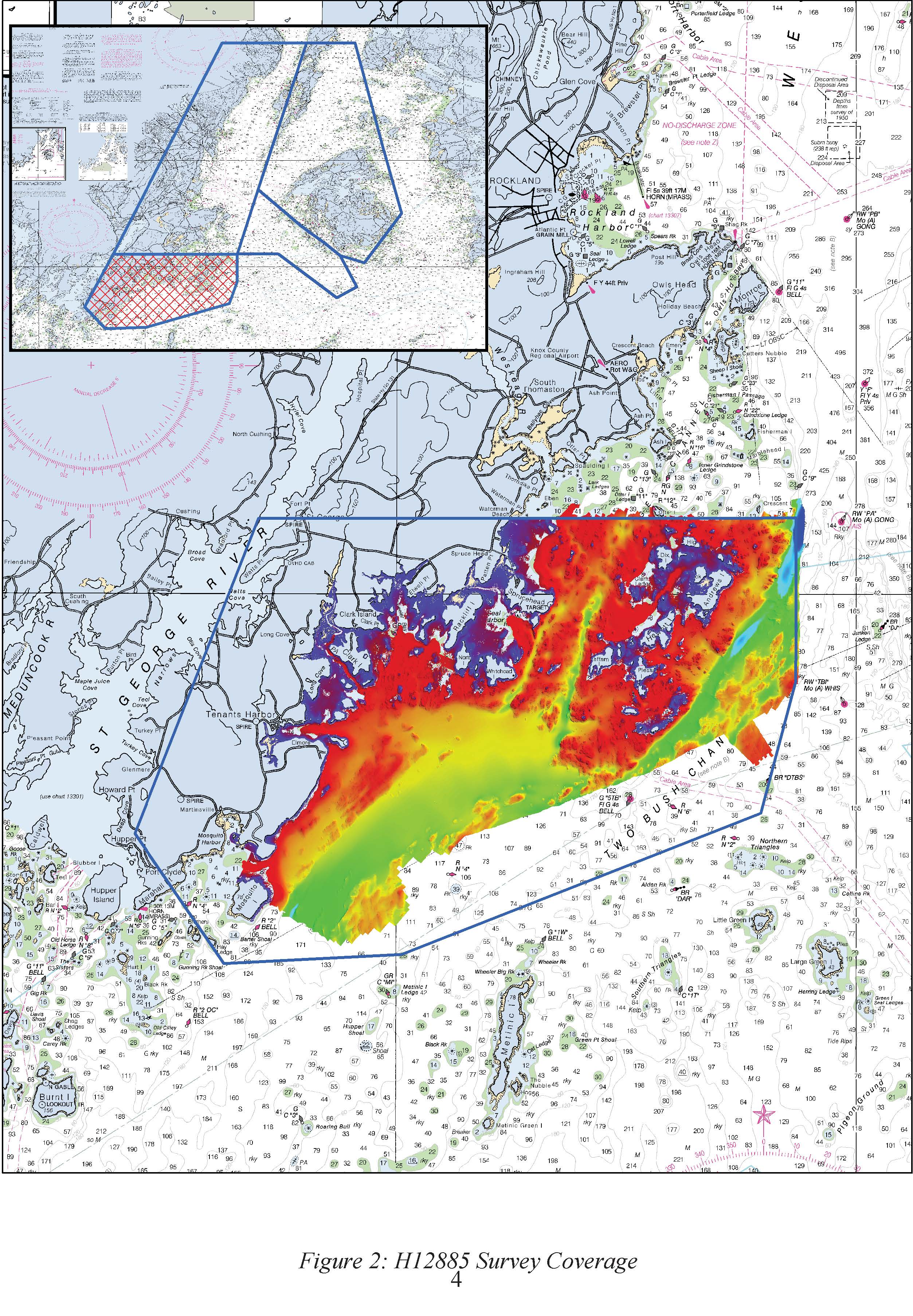
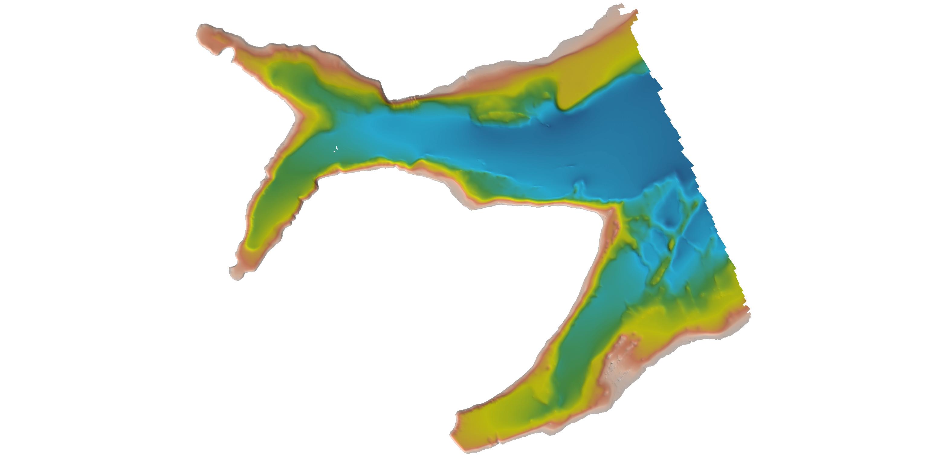
Federal
H12885: NOS Hydrographic Survey , 2016-09-29
National Oceanic and Atmospheric Administration, Department of Commerce —
The National Oceanic and Atmospheric Administration (NOAA) has the statutory mandate to collect hydrographic data in support of nautical chart compilation for safe... -
Federal
H07862: NOS Hydrographic Survey , 1950-12-31
National Oceanic and Atmospheric Administration, Department of Commerce —
The National Oceanic and Atmospheric Administration (NOAA) has the statutory mandate to collect hydrographic data in support of nautical chart compilation for safe... -
Federal
F00465: NOS Hydrographic Survey , No OPR Phone Conversation(F00465), 2000-05-31
National Oceanic and Atmospheric Administration, Department of Commerce —
The National Oceanic and Atmospheric Administration (NOAA) has the statutory mandate to collect hydrographic data in support of nautical chart compilation for safe... -
Federal
L00959: NOS Hydrographic Survey , 1902-12-31
National Oceanic and Atmospheric Administration, Department of Commerce —
The National Oceanic and Atmospheric Administration (NOAA) has the statutory mandate to collect hydrographic data in support of nautical chart compilation for safe... -
Federal
H11195: NOS Hydrographic Survey , Southwest Alaska Peninsula, Alaska, 2003-06-06
National Oceanic and Atmospheric Administration, Department of Commerce —
The National Oceanic and Atmospheric Administration (NOAA) has the statutory mandate to collect hydrographic data in support of nautical chart compilation for safe... -
Federal
H07947: NOS Hydrographic Survey , 1951-12-31
National Oceanic and Atmospheric Administration, Department of Commerce —
The National Oceanic and Atmospheric Administration (NOAA) has the statutory mandate to collect hydrographic data in support of nautical chart compilation for safe...

Official websites use .gov
A
.gov website belongs to an official government
organization in the United States.
Secure .gov websites use HTTPS
A
lock (
) or https:// means you’ve safely connected to
the .gov website. Share sensitive information only on official,
secure websites.
.jpg)
.jpg)