
-
Federal
NorWeST Stream Temperatures 1993-2011 (Feature Layer)
Department of Agriculture —
This layer represents modeled stream temperatures derived from the NorWeST point feature class (NorWest_TemperaturePoints). NorWeST summer stream temperature... -
Federal
Benthic Habitats of Puerto Rico and the U.S. Virgin Islands; Photomosaic of Puerto Rico (Isabela), 1999
National Oceanic and Atmospheric Administration, Department of Commerce —
Habitat maps of Puerto Rico and the U.S. Virgin Islands were created by visual interpretation of aerial photographs using the Habitat Digitizer Extension. Aerial... -
Federal
CRED 20 m Gridded bathymetry of Jarvis Island, Pacific Remote Island Areas, Central Pacific (Arc ASCII Format)
National Oceanic and Atmospheric Administration, Department of Commerce —
Gridded (20 m cell size) bathymetry of the shelf and slope environments of Jarvis Island, Pacific Remote Island Areas, Central Pacific. Almost complete bottom... -
Federal
Bathymetric Position Index (BPI) Structures 10 m grid derived from gridded bathymetry of Agrihan Island, Commonwealth of the Northern Mariana Islands (CNMI), USA.
National Oceanic and Atmospheric Administration, Department of Commerce —
BPI Structures are derived from two scales of a focal mean analysis on bathymetry and slope. The grid is based on gridded (10 m cell size) multibeam bathymetry,... -
Federal
NorWeST Stream Temperatures 2080s (Feature Layer)
Department of Agriculture —
This layer represents modeled stream temperatures derived from the NorWeST point feature class (NorWest_TemperaturePoints). NorWeST summer stream temperature... -
Federal
TIGER/Line Shapefile, Current, County, Judith Basin County, MT, All Roads
U.S. Census Bureau, Department of Commerce —
This resource is a member of a series. The TIGER/Line shapefiles and related database files (.dbf) are an extract of selected geographic and cartographic information... -
Federal
TIGER/Line Shapefile, 2023, County, Judith Basin County, MT, Linear Hydrography
U.S. Census Bureau, Department of Commerce —
The TIGER/Line shapefiles and related database files (.dbf) are an extract of selected geographic and cartographic information from the U.S. Census Bureau's Master... -
Federal
Pre-Delta-X: Total Suspended Solids of Surface Water across MRD, LA, USA, 2015-2016
National Aeronautics and Space Administration —
This dataset contains the total suspended solids (TSS) concentration of in situ water samples collected at selected sites across the Atchafalaya and Terrebonne Basins... -
Federal
LBA-ECO ND-03 Stream and Soil Water Data, Fazenda Nova Vida, Rondonia: 1994-2001
National Aeronautics and Space Administration —
This data set provides the results of (1) the physical and chemical characterization of streams and (2) comparable chemical analyses of extracted soil water in the... -
Federal
BASIN TCP Stable Isotope Composition of CO2 in Terrestrial Ecosystems
National Aeronautics and Space Administration —
This data set reports stable isotope ratio data of CO2 (13C/12C and 18O/16O) associated with photosynthetic and respiratory exchanges across the biosphere-atmosphere... -
Federal
LBA-ECO CD-06 Water Balance of the Ji-Parana River Basin, Brazil: 1995-1996
National Aeronautics and Space Administration —
This data set provides simulated minimum, average, and maximum monthly rainfall, potential evapotranspiration, water deficit, and water surplus values for the Ji-... -
University
Soil Survey Geographic (SSURGO) database for White Sands Missile Range, New Mexico, Parts of Dona Ana, Lincoln, Otero, Sierra and Socorro Counties
Earth Data Analysis Center, University of New Mexico —
This data set is a digital soil survey and generally is the most detailed level of soil geographic data developed by the National Cooperative Soil Survey. The... -
Federal
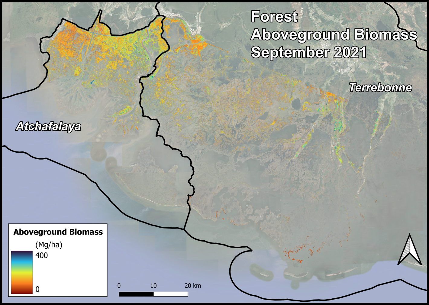
Delta-X AVIRIS-NG and UAVSAR L3 Derived Forest Aboveground Biomass, MRD, LA
National Aeronautics and Space Administration —
This dataset contains estimates of forest aboveground biomass (AGB) across the Atchafalaya and Terrebonne Basins, Louisiana, US. AGB was derived from AVIRIS-NG... -
Federal
Machine Learning Model Geotiffs - Applications of Machine Learning Techniques to Geothermal Play Fairway Analysis in the Great Basin Region, Nevada
Department of Energy —
This submission contains geotiffs, supporting shapefiles and readmes for the inputs and output models of algorithms explored in the Nevada Geothermal Machine Learning... -
State
Quaternary Geology LIS Lacustrine Fan Deposits
State of Connecticut —
Connecticut Quaternary Geology Long Island Submerged Marine Fluvial-Estuarine, Channel-Fill Deposits identifies early postglacial, channel-fill deposits submerged in... -
City
Louisville Metro KY - Pool Inspections
Louisville Metro Government —
Routine reinspection of over 537 public pools and treated water aquatic facilities in the US State of Kentucky, totalling over 2,000 inspections per year.... -
Federal
Great Basin Montane Watersheds - Regions (Feature Layer)
Department of Agriculture —
Multiple research and management partners collaboratively developed a multiscale approach for assessing the geomorphic sensitivity of streams and ecological... -
Federal
CRED 5 m Gridded bathymetry of Kingman Reef, Pacific Remote Island Areas, Central Pacific (NetCDF Format)
National Oceanic and Atmospheric Administration, Department of Commerce —
Gridded (5 m cell size) bathymetry of the lagoon, shelf and slope environments of Kingman Reef, Pacific Remote Island Areas, Central Pacific. Almost complete bottom... -
Federal
Benthic Habitats of Puerto Rico and the U.S. Virgin Islands; Photomosaic of Puerto Rico (Barceloneta), 1999
National Oceanic and Atmospheric Administration, Department of Commerce —
Habitat maps of Puerto Rico and the U.S. Virgin Islands were created by visual interpretation of aerial photographs using the Habitat Digitizer Extension. Aerial... -
State
Forestry Districts
Vermont Center for Geographic Information —
The Forestry Districts layer is part of a dataset that contains administrative boundaries for Vermont's Agency of Natural Resources. This is a layer file which...

Official websites use .gov
A
.gov website belongs to an official government
organization in the United States.
Secure .gov websites use HTTPS
A
lock (
) or https:// means you’ve safely connected to
the .gov website. Share sensitive information only on official,
secure websites.