
-
Federal
Spatio-temporal Characteristics of Rainfall in Africa, 0.25 degrees, from 1998-2012
National Aeronautics and Space Administration —
This data set describes rainfall distribution statistics over the African continent, including Madagascar. The rainfall estimates are based on data from the NASA... -
Federal
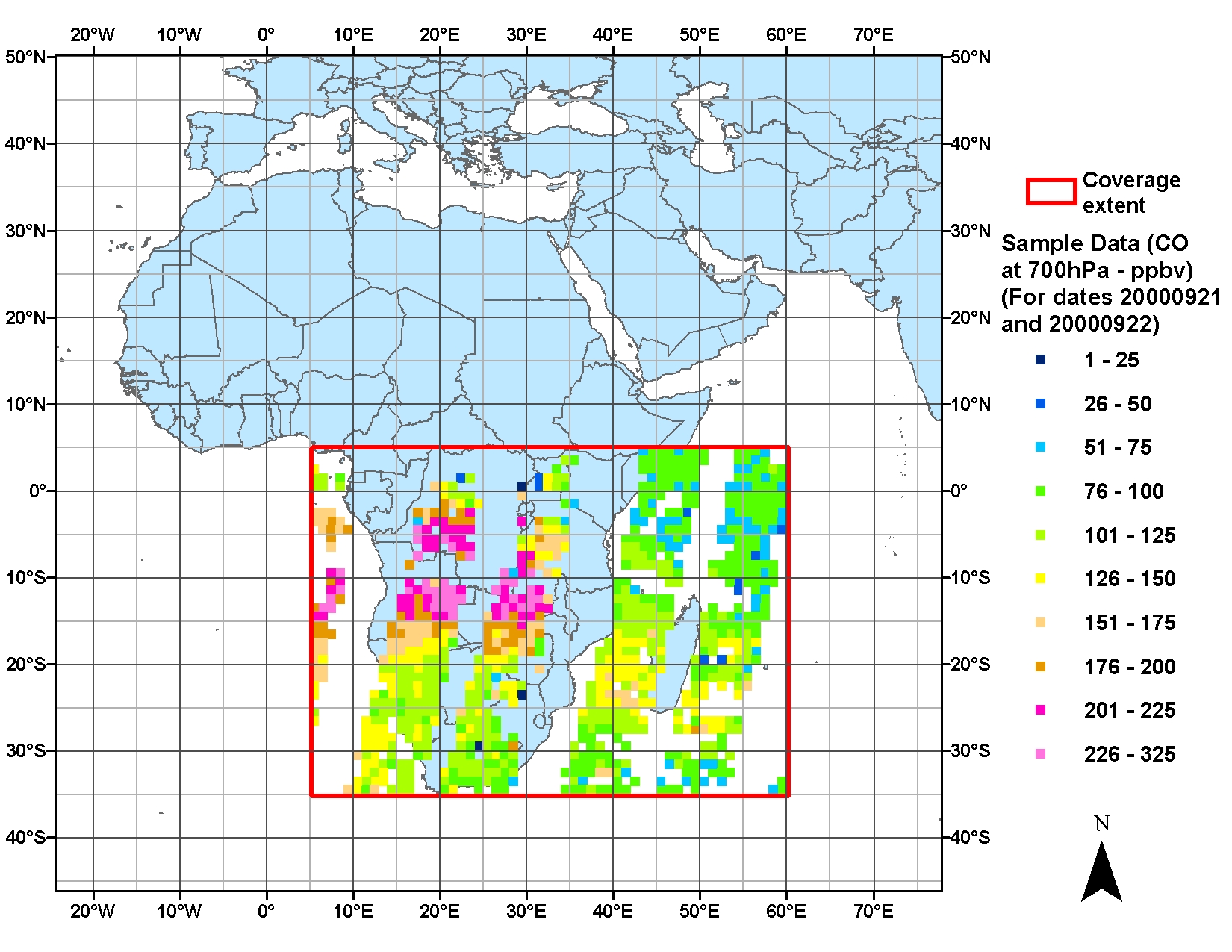
SAFARI 2000 MOPITT Tropospheric Carbon Monoxide, Southern Africa, Dry Season 2000
National Aeronautics and Space Administration —
The MOPITT (Measurements Of Pollution In The Troposphere) instrument on the NASA Terra Satellite makes measurements of infrared radiation originating from the surface... -
Federal
SAFARI 2000 Modeled Tropospheric Air Mass Trajectories, Dry Season 2000
National Aeronautics and Space Administration —
The ETA Forecast Trajectory Model was used to produce forecasts of air-parcel trajectories twice a day at three pressure levels over seven sites in Southern Africa... -
Federal
SAFARI 2000 Soil Properties, Moisture, and Temp., Skukuza and Mongu, 1999-2001
National Aeronautics and Space Administration —
Soil moisture and temperature profile sensors were deployed at flux tower sites in Mongu, Zambia and Skukuza, South Africa. In addition, thermal infrared sensors were... -
Federal
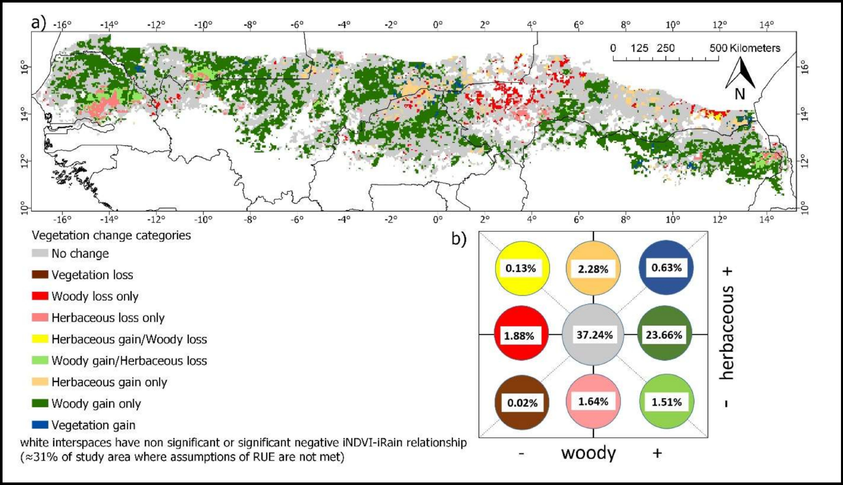
Woody and Herbaceous Vegetation Change across the Savannas of West Africa, 1982-2013
National Aeronautics and Space Administration —
The WAVeTrends dataset is a 0.05 degree (5.55 km) vegetation change product, spanning the West African Sudano-Sahel region. It provides pixel-wise information on... -
Federal
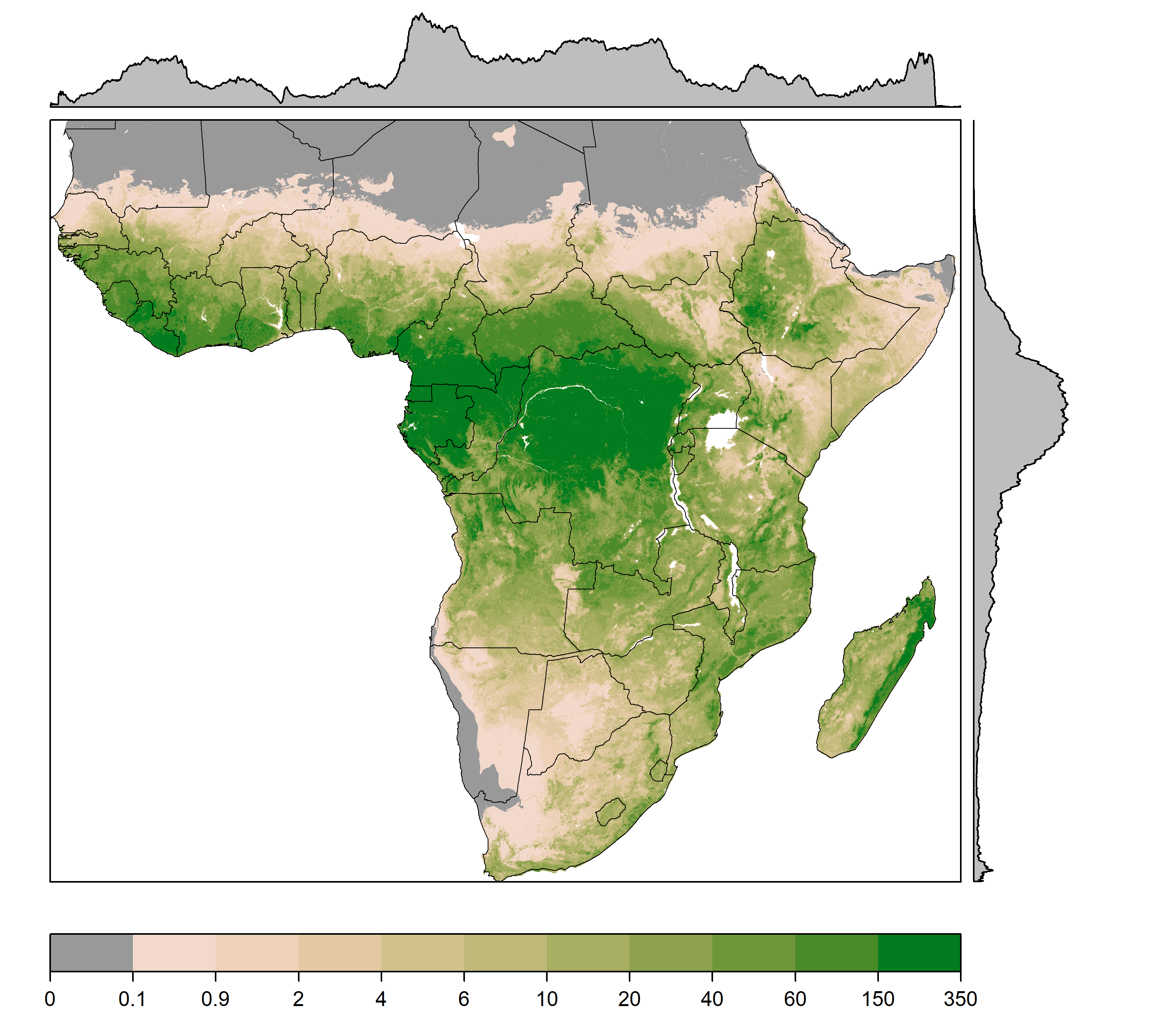
Gridded Estimates of Woody Cover and Biomass across Sub-Saharan Africa, 2000-2004
National Aeronautics and Space Administration —
This dataset provides maps of woody (tree and shrub) cover and biomass across Sub-Saharan Africa at a resolution of 1 km for the period 2000-2004. Canopy cover... -
Federal
SAFARI 2000 Meteorological Tower Measurements, Kruger National Park, 2000-2002
National Aeronautics and Space Administration —
An eddy covariance system mounted on a tower near the Skukuza Camp in Kruger National Park, South Africa, has been operating continuously since early 2000.... -
Federal
SAFARI 2000 Upper Air Meteorological Profiles, Skukuza, Dry Seasons 1999-2000
National Aeronautics and Space Administration —
Vaisala RS80 sondes were deployed from Skukuza Airport, South Africa, to collect atmospheric sounding profiles of temperature and moisture data from the surface to 30... -
Federal
SAFARI 2000 NBI Vegetation Map of the Savannas of Southern Africa
National Aeronautics and Space Administration —
The National Botanical Institute (NBI) has mapped woody plant species distribution to provide estimates of individual species contribution to peak leaf area index for... -
Federal
SAFARI 2000 Kalahari Transect CO2, Water Vapor, and Heat Flux, Wet Season 2000
National Aeronautics and Space Administration —
Short-term measurements of carbon dioxide, water, and energy fluxes were collected at four locations along a mean annual precipitation gradient in southern Africa... -
Federal
SAFARI 2000 Surface Albedo and Radiation Fluxes at Mongu and Skukuza, 2000-2002
National Aeronautics and Space Administration —
Top-of-the-canopy broadband albedo and radiation fluxes are calculated from measurements at the Mongu and Skukuza flux tower sites in southern Africa from March 2000... -
Federal
BioSCape Vegetation Surveys Berg and Eerste River Catchments, South Africa, 2022-2023
National Aeronautics and Space Administration —
This dataset contains vegetation plot survey data collected at 36 sites across the Berg and Eerste River catchments in the Western Cape, South Africa collected during... -
Federal
SAFARI 2000 Potential Vegetation, 5-min (Ramankutty and Foley)
National Aeronautics and Space Administration —
The data set consists of a southern Africa subset of the 5-min resolution Global Potential Vegetation data set developed by Navin Ramankutty and Jon Foley at the... -
Federal
SAFARI 2000 MODIS MOD04_L2 Aerosol Data, GRANT Format, for Southern Africa
National Aeronautics and Space Administration —
The subset of the Moderate Resolution Imaging Spectroradiometer (MODIS) MOD04_L2 aerosol product provided in this data set represents the swaths that coincide with... -
Federal
SAFARI 2000 MODIS L3 Albedo and Land Cover Data, Southern Africa, Dry Season 2000
National Aeronautics and Space Administration —
The Filled Land Surface Albedo Product for Southern Africa, which is generated from MOD43B3 Product (the official Terra/MODIS-derived Land Surface Albedo -... -
Federal
SAFARI 2000 Upper Air Meteorological Profiles, South Africa, Dry Season 2000
National Aeronautics and Space Administration —
The University of Wyoming has a series of balloonborne radiosonde measurements from all around the world, from the surface to 30 km. This data set contains upper air... -
Federal
SAFARI 2000 MODIS MOD05_L2 Water Vapor Data, Binary Format, for Southern Africa
National Aeronautics and Space Administration —
The Moderate Resolution Imaging Spectroradiometer (MODIS) precipitable water product consists of vertical column water-vapor amounts in centimeters (cm) at 1-km... -
Federal
CMS: Estimated Deforested Area Biomass, Tropical America, Africa, and Asia, 2000
National Aeronautics and Space Administration —
This data set provides estimates of pre-deforestation aboveground live woody biomass (AGLB) at 30-m resolution for deforested areas of tropical America, tropical...

Official websites use .gov
A
.gov website belongs to an official government
organization in the United States.
Secure .gov websites use HTTPS
A
lock (
) or https:// means you’ve safely connected to
the .gov website. Share sensitive information only on official,
secure websites.