

317 datasets found for "400多款微信公众号朋友圈小游戏源码合集 全部手机平板自适应+HTML5✅项目合作 二开均可 TG:saolei44✅.rhxWxSTNcJMDp"
-
Federal
Physical, chemical, and biological water quality monitoring data to support detection of Harmful Algal Blooms (HABs) in western Lake Erie, collected by the Great Lakes Environmental Research Laboratory and the Cooperative Institute for Great Lakes Research since 2012
National Oceanic and Atmospheric Administration, Department of Commerce —
Blooms of nuisance and toxic cyanobacteria, referred to as cyanobacteria harmful algal blooms (cHABs), occur annually in Lake Erie and pose a threat to human health,... -
State
DWR Airborne Electromagnetic (AEM) Surveys Data
State of California —
Statewide AEM Surveys Project Overview The Department of Water Resources’ (DWR’s) Statewide Airborne Electromagnetic (AEM) Surveys Project is funded through... -
City
Neighborhood Watch Areas
City of Sioux Falls —
Feature layer containing authoritative neighborhood watch area polygons for Sioux Falls, South Dakota. -
Federal
AK Leases
Department of the Interior —
This data set contains the outlines for active and inactive federal oil and gas leases in the Alaska OCS Region. OCS Lease Blocks that are currently leased from the... -
City
City of Sioux Falls Traffic Count Viewer
City of Sioux Falls —
Application containing traffic count information for Sioux Falls, South Dakota.Traffic counts represent 24-hour, weekday, two-way volumes. These are adjusted by day... -
Federal
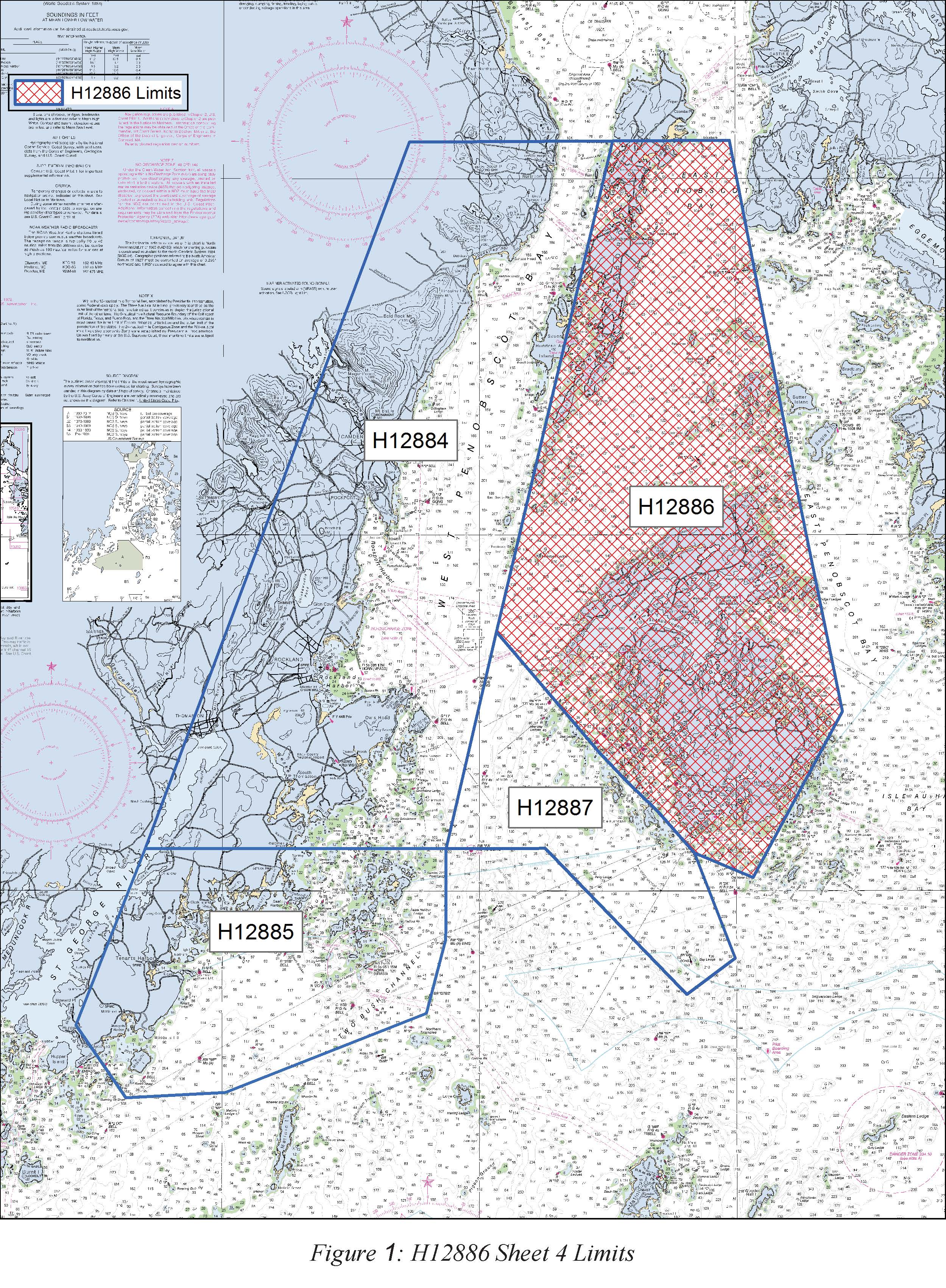
H12886: NOS Hydrographic Survey , 2016-09-30
National Oceanic and Atmospheric Administration, Department of Commerce —
The National Oceanic and Atmospheric Administration (NOAA) has the statutory mandate to collect hydrographic data in support of nautical chart compilation for safe... -
City
Joint Jurisdiction
City of Sioux Falls —
Feature layer containing authoritative joint jurisdiction polygons for Sioux Falls, South Dakota. -
County
Administrative Hearings - Top 5 Environmental Control Violations - Fiscal Year 2011 Incomplete
Cook County of Illinois —
Data covers December 1, 2010 through September 22, 2011 -
State
Vegetation - San Mateo County [ds3021]
State of California —
In 2018, the Golden Gate National Parks Conservancy (Parks Conservancy) (https://parksconservancy.org), non-profit support partner to the National Park Service (NPS)... -
Federal
Post-fire (20211019) Cover for the Muckamuck Fire
Department of the Interior —
Post-fire vegetation status and condition have multiple implications. They are indicative of burn severity and the lasting impacts of fire the land; they also help... -
Federal
Mediterranean, Indian and Pacific Ocean Transect (MIPOT)
National Aeronautics and Space Administration —
Measurements made during Mediterranean, Indian and Pacific Ocean Transect (MIPOT) cruises in 2001. -
Federal
Tree Canopy Cover for the Circumpolar Taiga-Tundra Ecotone: 2000-2005
National Aeronautics and Space Administration —
This data set provides a map of selected areas with defined tree canopy cover over the circumpolar taiga-tundra ecotone (TTE). Canopy cover was derived from the... -
Federal
CLPX-Ground: ISA Soil Moisture Measurements, Version 1
National Aeronautics and Space Administration —
This data set consists of in-situ point measurements of soil moisture within three 25-km by 25-km Meso-cell Study Areas (MSAs) in northern Colorado (Fraser, North... -
Federal
Nutrition Assistance Programs Performance Report
Department of Agriculture —
This report provides data regarding the nutrition assistance programs performance report for August 2014. The report reflects the participation of persons in FNS'... -
State
Sonora Mud Turtle Range - CWHR R002 [ds1712]
State of California —
Vector datasets of CWHR range maps are one component of California Wildlife Habitat Relationships (CWHR), a comprehensive information system and predictive model for... -
State
Pied-billed Grebe Range - CWHR B006 [ds1398]
State of California —
Vector datasets of CWHR range maps are one component of California Wildlife Habitat Relationships (CWHR), a comprehensive information system and predictive model for... -
Federal
Microbarograph - ESRL Hi-Res Microbarograph, Wasco Airport - Reviewed Data
Department of Energy —
Overview High-precision barometers (Paroscientific 6000-16B-IS) are combined with Nishiyama-Bedard Quad Disk pressure probes, measuring pressure (mb) at the surface,... -
State
Greater Yellowlegs Predicted Habitat - CWHR B165 [ds2122]
State of California —
The datasets used in the creation of the predicted Habitat Suitability models includes the CWHR range maps of Californias regularly-occurring vertebrates which were... -
State
Total Generation by Type and County: 2018
State of California —
Reporting requirements for power plants at least 1 MW are in accordance with 20 CA CCR 304 and 1385. Counties without pie symbols had no utility-scale (commercial)...
317 datasets found for "400多款微信公众号朋友圈小游戏源码合集 全部手机平板自适应+HTML5✅项目合作 二开均可 TG:saolei44✅.rhxWxSTNcJMDp"