
-
Federal
Delta-X: AirSWOT L2 Geocoded Water Surface Elevation, MRD, LA, 2021, V3
National Aeronautics and Space Administration —
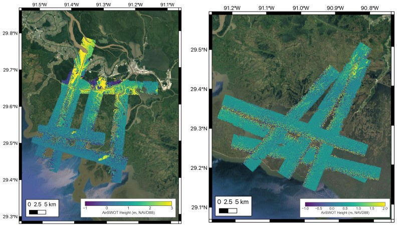
This dataset contains Level 2 (L2) AirSWOT geocoded products, including estimated water surface elevation. The AirSWOT instrument is a Ka-band interferometer and for... -
Federal
Delta-X: Acoustic Doppler Current Profiler Channel Surveys, MRD, Louisiana, 2021, V2
National Aeronautics and Space Administration —
This dataset provides river discharge measurements collected at selected locations in the Atchafalaya and Terrebonne Basins within the Mississippi River Delta (MRD)... -
Federal
ABoVE: Lake and Wetland Classification from L-band SAR, Alaska and Canada, 2017-2019
National Aeronautics and Space Administration —
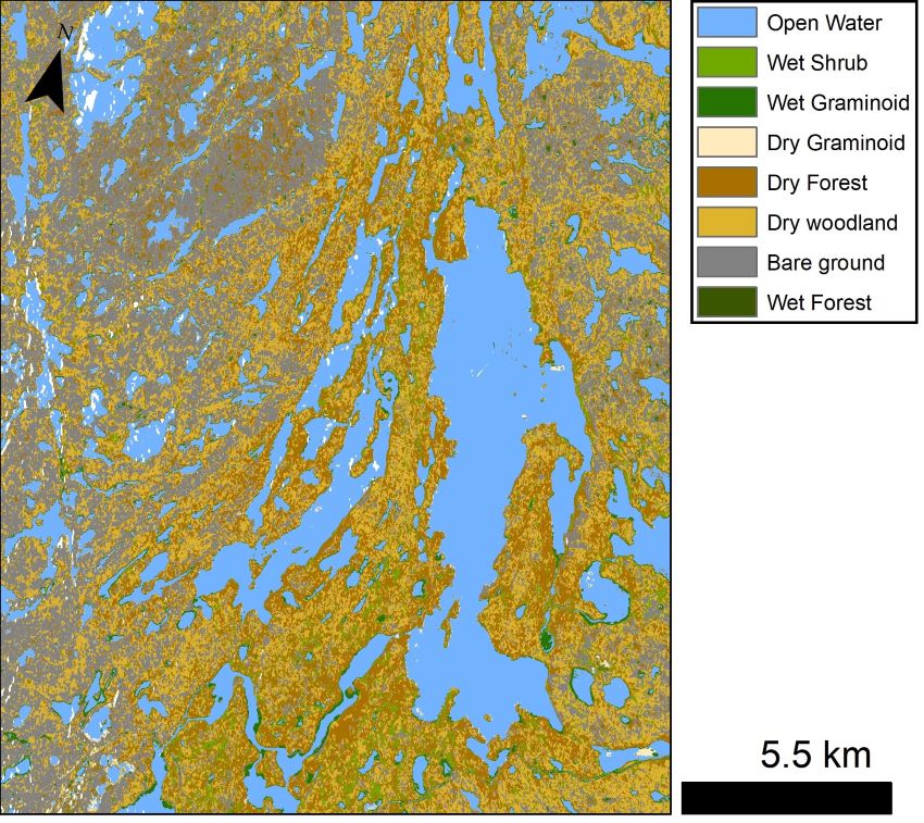
This dataset contains a high-resolution land cover classification focused on water and wetland vegetation classes over three NASA ABoVE Campaign regions: Yukon Flats,... -
Federal
ABoVE: SAR-based Methane Ebullition Flux from Lakes, Five Regions, Alaska, 2007-2010
National Aeronautics and Space Administration —
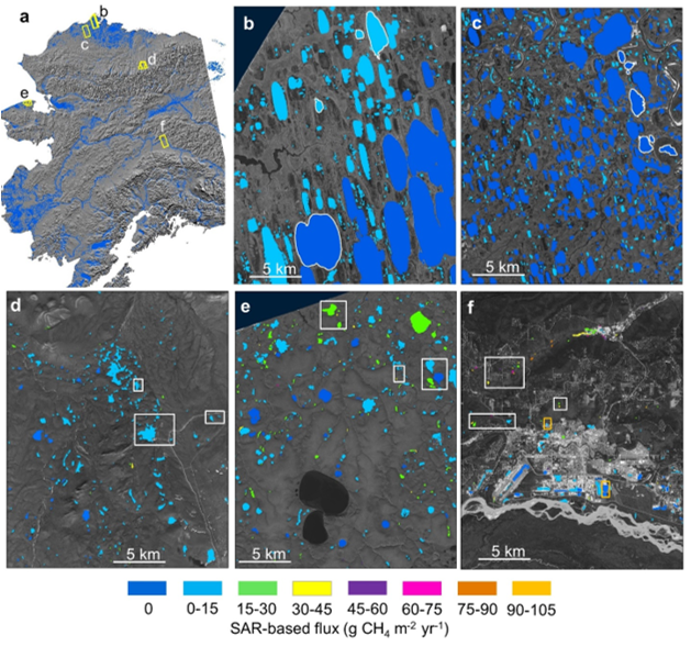
This dataset provides Synthetic Aperture Radar (SAR) estimates of lake-source methane ebullition flux in mg CH4/m2/d for thousands of lakes in five regions across... -
Federal
BOREAS TF-11 CO2 and CH4 Flux Data from the SSA-Fen
National Aeronautics and Space Administration —
The BOREAS TF-11 team collected several data sets in their efforts to fully describe the flux and site characteristics at the SSA-Fen site. This data set contains... -
Federal
BOREAS TF-11 SSA Fen Soil Surface CO2 Flux Data
National Aeronautics and Space Administration —
The BOREAS TF-11 team gathered a variety of data to complement their tower flux measurements collected at the SSA Fen site. These data are soil surface CO2 flux data... -
Federal
ISLSCP II Global River Fluxes of Carbon and Sediments to the Oceans
National Aeronautics and Space Administration —
The River Carbon Flux data set represents estimates for the riverine export of carbon and of sediments. This data set includes the amounts of carbon and of sediments... -
Federal
SWOT Level 2 Water Mask Pixel Cloud Data Product, Version C
National Aeronautics and Space Administration —
Point cloud of water mask pixels (“pixel cloud”) with geolocated heights, backscatter, geophysical fields, and flags. Point cloud over tile (approx 64x64 km2); half... -
Federal
SWOT Level 2 Water Mask Raster Image 100m Data Product, Version D
National Aeronautics and Space Administration —
The SWOT Level 2 KaRIn High Rate Raster Product (SWOT_L2_HR_Raster_D) provides rasterized estimates of water surface elevation, inundation extent, and radar... -
Federal
SWOT Level 2 Water Mask Raster Image 100m Data Product, Version C
National Aeronautics and Space Administration —
The SWOT Level 2 Water Mask Raster Image 100m Data Product from the Surface Water Ocean Topography (SWOT) mission provides global surface water elevation and... -
Federal
Pre-Delta-X: Water Levels across Wax Lake Outlet, Atchafalaya Basin, LA, USA, 2016
National Aeronautics and Space Administration —
This dataset provides absolute water level elevations derived for 10 locations across the Wax Lake Delta, Atchafalaya Basin, in Southern Louisiana, USA, within the... -
Federal
The Lake Observations by Citizen Scientists & Satellites (LOCSS) Level 1 Version 1.0
National Aeronautics and Space Administration —
This dataset contains data from the Lake Observations by Citizen Science and Satellites project, LOCSS which is a lake monitoring network. The data represent the... -
Federal
SWOT Simulated Level 2 North America Continent High Rate Lake Vectors Product Version 1.0
National Aeronautics and Space Administration —
This dataset contains a simulated lake product to be provided by the Surface Water and Ocean Topography (SWOT) mission with a focus on the North America continent.... -
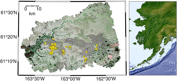
Federal
CO2 and CH4 Fluxes from Waterbodies, Yukon-Kuskokwim Delta, Alaska, 2016-2019
National Aeronautics and Space Administration —
This dataset provides estimates of carbon dioxide (CO2) and methane (CH4) diffusive fluxes from waterbodies, and watershed landcover data for the central-interior of... -
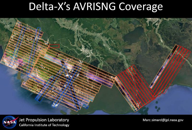
Federal
Delta-X: AVIRIS-NG L2 Surface Reflectance, MRD Louisiana, 2021
National Aeronautics and Space Administration —
This dataset provides Level 2 (L2) atmospherically corrected surface reflectance data acquired from NASA's Airborne Visible-Infrared Imaging Spectrometer-Next... -
Federal
LBA Regional Hydrographic Data, 1-Degree, Release 2.2 (Cogley)
National Aeronautics and Space Administration —
This subset of the Global Hydrographic data set (GGHYDRO) Release 2.2 for the study area of the Large Scale Biosphere-Atmosphere Experiment in Amazonia (LBA) in South... -
Federal
SWOT Level 2 Lake Cycle-Averaged Data Product, Version D
National Aeronautics and Space Administration —
Cycle average and aggregation of lake pass data within predefined hydrological basins. Basin for each cycle. Available in Shapefile file format. -
Federal
ABoVE: Lake and Pond Extents in Alaskan Boreal and Tundra Subregions, 2019-2021
National Aeronautics and Space Administration —
This dataset provides polygon spatial files of lake and pond extents for three sub-regions of Interior Alaska's boreal forest, and one tundra region located in... -
Federal
SWOT Level 2 River Cycle-Averaged Data Product, Version D
National Aeronautics and Space Administration —
Cycle average and aggregation of river reach pass data within predefined hydrological basins. Basin for each cycle. Available in Shapefile file format. -
Federal
LBA-ECO LC-24 Forest Cover Map from MODIS, 500-m, South America: 2001
National Aeronautics and Space Administration —
This data set, LBA-ECO LC-24 Forest Cover Map from MODIS, 500-m, South America: 2001, contains forest cover information for 2001 for all of South America. The data...

Official websites use .gov
A
.gov website belongs to an official government
organization in the United States.
Secure .gov websites use HTTPS
A
lock (
) or https:// means you’ve safely connected to
the .gov website. Share sensitive information only on official,
secure websites.