
-
Federal
LPJ-EOSIM L2 Global Simulated Monthly Wetland Methane Flux Low Latency V001
National Aeronautics and Space Administration —
The Lund-Potsdam-Jena Earth Observation SIMulator (LPJ-EOSIM) model estimates global wetland methane (CH4) emissions using simulated wetland extent and... -
Federal
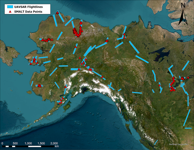
ABoVE: Soil Moisture and Active Layer Thickness in Alaska, USA and Canada, 2005-2022
National Aeronautics and Space Administration —
This dataset provides soil thaw depth and moisture measurements and dielectric properties measured by different research teams at sites in Alaska, U.S., and the... -
Federal
LBA-ECO ND-04 Pasture Soil Water and Precipitation, Km 54, Manaus, Brazil: 1999-2001
National Aeronautics and Space Administration —
This data set contains soil water measurements to a depth of 3 meters for the years 1999, 2000, and 2001, and total monthly precipitation data for 1999-2000. The data... -
Federal
CARVE: L1 In-situ Carbon and CH4 Flux and Meteorology at EC Towers, Alaska, 2011-2015
National Aeronautics and Space Administration —
This data set provides ground in situ flux and meteorological science data from fixed instruments at three eddy covariance tower sites located in the Alaskan Arctic... -
Federal
BOREAS TGB-01/TGB-03 Water Table and Peat Temperature Data over the NSA
National Aeronautics and Space Administration —
The BOREAS TGB-01 and TGB-03 teams collected several data sets that contributed to understanding the measured trace gas fluxes over sites in the NSA. This data set... -
Federal
LBA-ECO ND-02 Soil Gas and Water Content, Rainfall Exclusion, Tapajos National Forest
National Aeronautics and Space Administration —
This data set reports soil carbon dioxide (CO2) and nitrous oxide (N2O) concentrations and soil volumetric water content (VWC) from a rainfall exclusion experiment... -
Federal
LBA-ECO CD-04 Meteorological and Flux Data, km 83 Tower Site, Tapajos National Forest
National Aeronautics and Space Administration —
We used two independent approaches, biometry and micrometeorology, to determine the net ecosystem production (NEP) of an old growth forest in Para, Brazil. Biometric... -
Federal
ABoVE: Active Layer Thickness from Remote Sensing Permafrost Model, Alaska, 2001-2015
National Aeronautics and Space Administration —
This dataset provides annual estimates of active layer thickness (ALT) at 1 km resolution across Alaska from 2001-2015. The ALT was estimated using a remote sensing-... -
Federal
Global Landslide Nowcast from LHASA L4 1 day 1 km x 1 km version 2.0.0 (Global_Landslide_Nowcast) at GES DISC
National Aeronautics and Space Administration —
The Global Landslide Nowcast addresses the need for real-time situational awareness of landslide hazard. The Landslide Hazard Assessment for Situational Awareness... -
Federal
LBA Regional Derived Soil Properties, 0.5-Deg (ISRIC-WISE)
National Aeronautics and Space Administration —
The data set consists of a subset of the ISRIC-WISE global data set of derived soil properties for the study area of the Large Scale Biosphere-Atmosphere Experiment... -
Federal
LBA-ECO CD-08 Tropical Forest Ecosystem Respiration, Manaus, Brazil
National Aeronautics and Space Administration —
Understanding how tropical forest carbon balance will respond to global change requires knowledge of individual heterotrophic and autotrophic respiratory sources,... -
Federal
NACP: Forest Carbon Stocks, Fluxes and Productivity Estimates, Western USA, 1979-2099
National Aeronautics and Space Administration —
This dataset contains annual estimates of carbon stocks, fluxes, and productivity over forested land in 11 states of the western USA (Arizona, California, Colorado,... -
Federal
LBA-ECO CD-32 Flux Tower Network Data Compilation, Brazilian Amazon: 1999-2006, V2
National Aeronautics and Space Administration —
This dataset is a compilation of carbon and energy eddy covariance flux, meteorology, radiation, canopy temperature, humidity, CO2 profiles and soil moisture and... -
Federal
VEMAP 1: U.S. Soil
National Aeronautics and Space Administration —
The Vegetation/Ecosystem Modeling and Analysis Project (VEMAP) is an ongoing multiinstitutional, international effort addressing the response of biogeography and... -
Federal
SAFARI 2000 Selected Soil Characteristics, 10-km Grid (IGBP-DIS)
National Aeronautics and Space Administration —
The data set consists of a southern African subset of the "Global Gridded Surfaces of Selected Soil Characteristics (IGBP-DIS)" produced by the International... -
Federal
SAFARI 2000 AVHRR-derived Land Surface Temperature Maps, Africa, 1995-2000
National Aeronautics and Space Administration —
Land Surface Temperature (LST) is a key indicator of land surface states, and can provide information on surface-atmosphere heat and mass fluxes, vegetation water... -
Federal
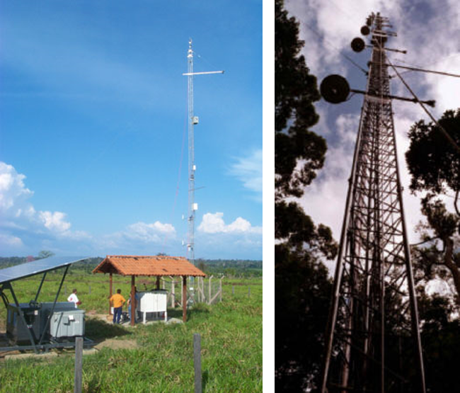
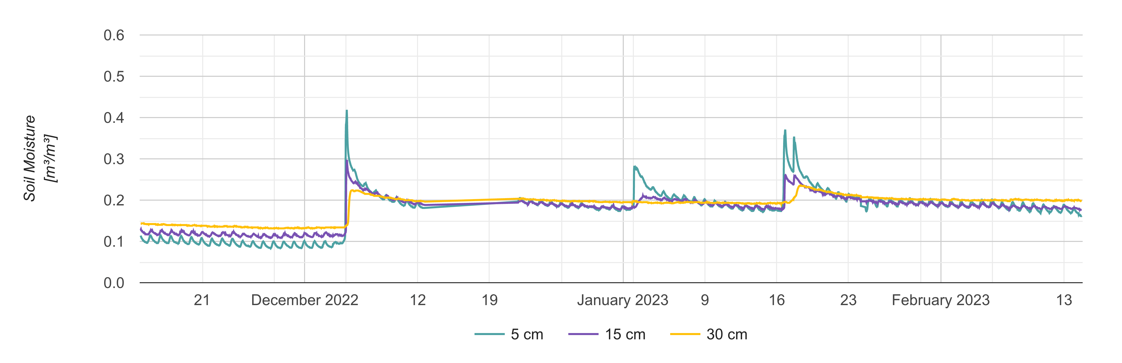
Soil Moisture Profiles and Temperature Data from SoilSCAPE Sites, Version 2
National Aeronautics and Space Administration —
This dataset contains in-situ soil moisture profile and soil temperature data collected at 30-minute intervals at SoilSCAPE (Soil moisture Sensing Controller and... -
Federal
Soil Moisture Gravimetric Data (FIFE)
National Aeronautics and Space Administration —
The gravimetrical soil moisture data were collected from many stations spread over the FIFE study area. These data were collected to characterize the spatial and...

Official websites use .gov
A
.gov website belongs to an official government
organization in the United States.
Secure .gov websites use HTTPS
A
lock (
) or https:// means you’ve safely connected to
the .gov website. Share sensitive information only on official,
secure websites.