
-
Federal
VEMAP 1: U.S. Potential Natural Vegetation
National Aeronautics and Space Administration —
The Vegetation/Ecosystem Modeling and Analysis Project (VEMAP) is an ongoing multiinstitutional, international effort addressing the response of biogeography and... -
Federal
SAFARI 2000 TOVS Surface and Atmospheric Parameters, 1-Deg, 1999-2001
National Aeronautics and Space Administration —
NOAA's TIROS (Television Infrared Observation Satellite) Operational Vertical Sounder (TOVS) is a suite of three sensors: the Microwave Sounding Unit (MSU), the High... -
Federal
Satellite Landsat TM Extr. Data (FIFE)
National Aeronautics and Space Administration —
The Thematic Mapper sensor system was used to collect the original data between February 1987 and October 1989 from which this data set was produced. Landsat TM... -
Federal
SAFARI 2000 Emissions Estimates, MODIS Burned Area Product, Dry Season 2000
National Aeronautics and Space Administration —
The recently generated MODIS burned area product over southern Africa for the month of September 2000 was used to calculate regional biomass burning emissions from... -
Federal
Water Quality and Spectral Reflectance, Peace-Athabasca Delta, Canada, 2010-2011
National Aeronautics and Space Administration —
The Peace-Athabasca Delta (PAD) is a hydrologically complex and ecologically diverse freshwater delta formed by the confluence of the Peace, Athabasca, and Birch... -
Federal
Wind Profile Data: LIDAR - NOAA (FIFE)
National Aeronautics and Space Administration —
The aim of this wind profile study was to derive wind profiles and momentum fluxes from the National Oceanic and Atmospheric Administration (NOAA)/Wave Propagation... -
Federal
PhenoCam Dataset v3.0: Vegetation Phenology from Digital Camera Imagery, 2000-2023
National Aeronautics and Space Administration —
This dataset provides vegetation phenological observations for 738 sites across diverse ecosystems of the world (mostly North America) from 2000 to 2023. The... -
Federal
Soil Bulk Density Data (FIFE)
National Aeronautics and Space Administration —
Soil bulk density is defined as the ratio of the mass of dry solids to the bulk volume of the soil occupied by those dry solids. Bulk density of the soil is an... -
Federal
Site Averaged AMS Data: 1989 (Betts)
National Aeronautics and Space Administration —
The Site Averaged AMS Data: 1989 (Betts) Data Set contains the site averaged product of the Portable Automatic Meteorological Station (AMS) data acquired during the... -
Federal
SNF Forest Understory Cover Data
National Aeronautics and Space Administration —
The purpose of the SNF study was to improve our understanding of the relationship between remotely sensed observations and important biophysical parameters in the... -
Federal
Site Averaged Gravimetric Soil Moisture: 1987 (Betts)
National Aeronautics and Space Administration —
The Site Averaged Gravimetric Soil Moisture Data: 1987 (Betts) Data Set contains the site averaged product data collected during the 1987-1989 FIFE experiment.... -
Federal
NPP Tropical Forest: Luquillo, Puerto Rico, 1946-1994, R1
National Aeronautics and Space Administration —
This data set contains ten ASCII files (.txt format), one NPP file for each of the nine different montane tropical rainforest sites within the Luquillo Experimental... -
Federal
NPP Tropical Forest: Cinnamon Bay, U.S. Virgin Islands, 1982-1993, R1
National Aeronautics and Space Administration —
This data set contains three ASCII files (.txt format). One data file contains above-ground biomass, litter, litterfall, herbivory, biomass change, and above-ground... -
Federal
Forest Inventories at Burned and Unburned Tropical Forest Sites, Acre, Brazil, 2014
National Aeronautics and Space Administration —
This dataset provides measurements for diameter at breast height (DBH) and species identification of trees for inventories taken at five tropical forest sites in Acre... -
Federal
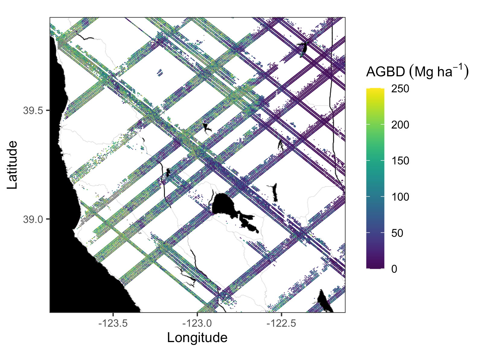
GEDI L4A Footprint Level Aboveground Biomass Density, Golden Weeks, Version 1
National Aeronautics and Space Administration —
This dataset contains Global Ecosystem Dynamics Investigation (GEDI) Level 4A (L4A) predictions of the aboveground biomass density (AGBD; in Mg/ha) and estimates of... -
Federal
Delta-X: AVIRIS-NG BRDF-Adjusted Surface Reflectance and Mosaics, MRD, LA, 2021, V3
National Aeronautics and Space Administration —
This data provides AVIRIS-NG Bidirectional Reflectance Distribution Function (BRDF) and sunglint-corrected surface spectral reflectance images over the Atchafalaya... -
Federal
ABoVE: TVPRM Simulated Net Ecosystem Exchange, Alaskan North Slope, 2008-2017
National Aeronautics and Space Administration —
This dataset includes hourly net ecosystem exchange (NEE) simulated by the Tundra Vegetation Photosynthesis and Respiration Model (TVPRM) at 30 km horizontal... -
Federal
ABoVE: Lake and Pond Extents in Alaskan Boreal and Tundra Subregions, 2019-2021
National Aeronautics and Space Administration —
This dataset provides polygon spatial files of lake and pond extents for three sub-regions of Interior Alaska's boreal forest, and one tundra region located in... -
Federal
BOREAS TGB-10 Oxidant Flux Data over the SSA
National Aeronautics and Space Administration —
The BOREAS TGB-10 team collected several trace gas data sets in their efforts to determine the role of biogenic hydrocarbon emissions with respect to boreal forest... -
Federal
BOREAS TE-18 Landsat TM Physical Classification Image of the SSA
National Aeronautics and Space Administration —
The objective of this classification is to provide the BOREAS investigators with a data product that characterizes the land cover of the SSA. A Landsat-5 TM image...

Official websites use .gov
A
.gov website belongs to an official government
organization in the United States.
Secure .gov websites use HTTPS
A
lock (
) or https:// means you’ve safely connected to
the .gov website. Share sensitive information only on official,
secure websites.