
-
Federal
Aircraft Flux-Raw: Univ. Col. (FIFE)
National Aeronautics and Space Administration —
The NCAR King Air participation in FIFE-1987 and FIFE-1989 was part of a coordinated atmospheric boundary layer component which included other aircraft, surface... -
Federal
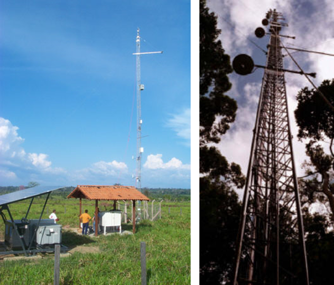
LBA-ECO CD-04 Meteorological and Flux Data, km 83 Tower Site, Tapajos National Forest
National Aeronautics and Space Administration —
We used two independent approaches, biometry and micrometeorology, to determine the net ecosystem production (NEP) of an old growth forest in Para, Brazil. Biometric... -
Federal
ISLSCP II Climate Research Unit CRU05 Monthly Climate Data
National Aeronautics and Space Administration —
This data set contains a mean monthly climatology for several climate variables averaged over the period from 1961 to 1990, and constructed from a data set of station... -
Federal
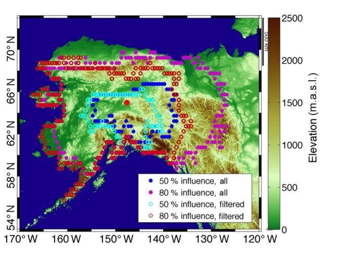
CARVE: L4 Gridded Footprints from WRF-STILT model, 2012-2016
National Aeronautics and Space Administration —
This data set provides Weather Research and Forecasting (WRF) Stochastic Time-Inverted Lagrangian Transport (STILT) Footprint data products for particle receptors... -
Federal
Atmos. Profile: Radiosonde - NCDC (FIFE)
National Aeronautics and Space Administration —
The NOAA Radiosonde Observations - 1989 (NCDC) Data Set contains radiosonde data obtained from the National Climatic Data Center (NCDC). These 396 days of data cover... -
Federal
Atmos. Profile: Std. Press. Level (FIFE)
National Aeronautics and Space Administration —
The FIFE Standard Pressure Level Radiosonde Data Set provides a set of standard level profiles (i.e., 5 mb pressure intervals) from over 450 radiosonde balloon... -
Federal
BOREAS/AES Campbell Scientific 15-minute Surface Meteorological Data: 1995
National Aeronautics and Space Administration —
Canadian AES personnel collected data related to surface and atmospheric meteorological conditions over the BOREAS Region. This data set contains 15 minute... -
Federal
BOREAS Follow-On HMet-02 Area and Regional Hourly Gridded Met. Data, 1994-1996
National Aeronautics and Space Administration —
Phase II and III gridded data sets have been generated by an objective analysis scheme using all of the surface meteorological station data over BOREAS region for... -
Federal
BOREAS AFM-01 NOAA/ATDD Long-EZ Aircraft Flux Data over the SSA
National Aeronautics and Space Administration —
This data set contains measurements from the NOAA/ATDD Long-EZ Aircraft collected during the 1994 IFCs at the SSA. These measurements were made from various... -
Federal
NACP Site: Tower Meteorology, Flux Observations with Uncertainty, and Ancillary Data
National Aeronautics and Space Administration —
This data set contains meteorological, carbon cycle flux, phenology, and ancillary data measured at 47 eddy covariance flux tower sites across North America. The data... -
Federal
LBA-ECO CD-32 Flux Tower Network Data Compilation, Brazilian Amazon: 1999-2006, V2
National Aeronautics and Space Administration —
This dataset is a compilation of carbon and energy eddy covariance flux, meteorology, radiation, canopy temperature, humidity, CO2 profiles and soil moisture and... -
Federal
LBA-ECO CD-32 LBA Model Intercomparison Project (LBA-MIP) Forcing Data
National Aeronautics and Space Administration —
The source meteorological observations for the forcing data, from the nine Brazilian flux towers, were recently published as Saleska, et al. (2013). See related data... -
Federal
SAFARI 2000 ETA Atmospheric Model Data, Wet and Dry Seasons 2000
National Aeronautics and Space Administration —
With modern computer power now capable of making mesoscale model output available in real time in the operational environment, increased attention has been given to... -
Federal
Surface Water Elevation and Quality, Peace-Athabasca Delta, Canada, 2006-2007
National Aeronautics and Space Administration —
The Peace-Athabasca Delta (PAD) is a large boreal wetland located in northeastern Alberta, Canada at the confluence of the Peace and Athabasca Rivers with Lake... -
Federal
Surface Meteorology Data: NCDC (FIFE)
National Aeronautics and Space Administration —
The NOAA Regional Surface Data - 1989 (NCDC) Data Set contains hourly surface meteorological data for the FIFE area. Though the measurements presented in this data... -
Federal
Site Averaged AMS Data: 1987-1989 (Betts)
National Aeronautics and Space Administration —
The Site Averaged AMS Data: 1987 - 1989 (Betts) Data Set contains the site averaged product of the Portable Automatic Meteorological Station (AMS) data acquired... -
Federal
Site Averaged AMS Data: 1988 (Betts)
National Aeronautics and Space Administration —
The Site Averaged AMS Data: 1988 (Betts) Data Set contains the site averaged product of the Portable Automatic Meteorological Station (AMS) data acquired during the... -
Federal
Site Averaged AMS Data: 1987 (Betts)
National Aeronautics and Space Administration —
The Site Averaged AMS Data: 1987 (Betts) Data Set contains the site averaged product of the Portable Automatic Meteorological Station (AMS) data acquired during the...

Official websites use .gov
A
.gov website belongs to an official government
organization in the United States.
Secure .gov websites use HTTPS
A
lock (
) or https:// means you’ve safely connected to
the .gov website. Share sensitive information only on official,
secure websites.