
-
Federal
SAFARI 2000 Vegetation Cover Characteristics, Kalahari Transect, Wet Season 2000
National Aeronautics and Space Administration —
Vegetation cover and composition, including species types and richness assessments, were measured at four locations along the Kalahari Transect in Botswana... -
Federal
Radiosonde Data: NOAA (FIFE)
National Aeronautics and Space Administration —
The NOAA Radiosonde Observations Data Set contains data that were extracted from the NOAA operational analysis system and transmitted to the FIS. Data are available... -
Federal
LBA Regional Organic Soil Carbon and Nitrogen Data (Zinke et al.)
National Aeronautics and Space Administration —
The data set contains a subset of a global organic soil carbon and nitrogen data set (Zinke et al. 1986). The subset was created for the study area of the Large Scale... -
Federal
BOREAS/AES Campbell Scientific 15-minute Surface Meteorological Data: 1995
National Aeronautics and Space Administration —
Canadian AES personnel collected data related to surface and atmospheric meteorological conditions over the BOREAS Region. This data set contains 15 minute... -
Federal
AVIRIS Facility Instruments: Flight Line Geospatial and Contextual Data
National Aeronautics and Space Administration —
This dataset provides attributed geospatial and tabular information for identifying and querying flight lines of interest for the Airborne Visible InfraRed Imaging... -
Federal
BOREAS AFM-13 Aircraft Flux Analyses
National Aeronautics and Space Administration —
For the BOReal Ecosystem-Atmosphere Study (BOREAS) in 1994 and 1996, the Airborne Fluxes and Meteorology (AFM) group was involved in measurements (from different... -
Federal
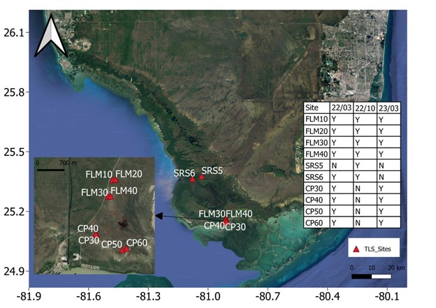
Blueflux: Terrestrial Lidar Scans of Mangrove Forests, Everglades, FL, USA, 2022-2023
National Aeronautics and Space Administration —
This dataset contains point clouds of three-dimensional (3D) mangrove forest structure and volume collected from 10 sites in Everglades National Park, Florida. Data... -
Federal
Global N Cycle: Fluxes and N2O Mixing Ratios Originating from Human Activity
National Aeronautics and Space Administration —
Nitrogen is a major nutrient in terrestrial ecosystems and an important catalyst in tropospheric photochemistry. Over the last century human activities have... -
Federal
Atmos. Profile: Radiosonde - NCDC (FIFE)
National Aeronautics and Space Administration —
The NOAA Radiosonde Observations - 1989 (NCDC) Data Set contains radiosonde data obtained from the National Climatic Data Center (NCDC). These 396 days of data cover... -
Federal
LBA-ECO CD-05 Soil VWC and Meteorology, Rainfall Exclusion, Tapajos National Forest
National Aeronautics and Space Administration —
This data set reports soil moisture expressed as volumetric water content (VWC), daily precipitation, air temperature, relative humidity, and dew point measurements... -
Federal
ABoVE: AirSWOT Color-Infrared Imagery Over Alaska and Canada, 2017
National Aeronautics and Space Administration —
This dataset contains georeferenced three-band orthomosaics of green, red, and near-infrared (NIR) digital imagery at 1m resolution collected over selected surface... -
Federal
Arctic Vegetation Plots on Unalaska Island, Aleutian Islands, Alaska, 2007
National Aeronautics and Space Administration —
This data set provides environmental, soil, and vegetation data collected during August 2007 from 69 study plots at the Unalaska Island research site, and one plot on... -
Federal
ABoVE: Atmospheric Gas Concentrations from Airborne Flasks, Arctic-CAP, 2017
National Aeronautics and Space Administration —
This dataset provides atmospheric carbon dioxide (CO2), methane (CH4), carbon monoxide (CO), molecular hydrogen (H2), nitrous oxide (N2O), sulfur hexafluoride (SF6),... -
Federal
BOREAS CanSIS Regional Soils Data in Vector Format, V2
National Aeronautics and Space Administration —
This data set contains soils data from the Canada Soil Information System (CanSIS) in ESRI Shapefile format for the provinces of Saskatchewan and Manitoba. They are... -
Federal
Anthropogenic Carbon Emission System, 2012-2017, Version 2
National Aeronautics and Space Administration —
This dataset provides estimates of hourly carbon dioxide (CO2) emissions from the combustion of fossil fuels at 1-km resolution for the coterminous United States... -
Federal
BOREAS/AES Campbell Scientific 15-minute Surface Meteorological Data: 1994
National Aeronautics and Space Administration —
Canadian AES personnel collected data related to surface and atmospheric meteorological conditions over the BOREAS Region. This data set contains 15 minute... -
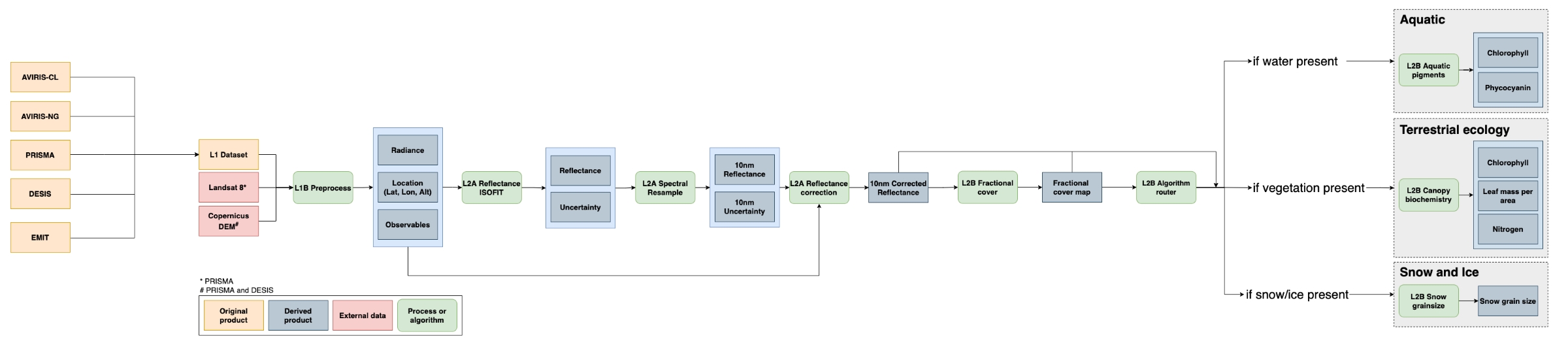
Federal
SISTER: Experimental Workflows, Product Generation Environment, and Sample Data, V004
National Aeronautics and Space Administration —
The Space-based Imaging Spectroscopy and Thermal pathfindER (SISTER) activity originated in support of the NASA Earth System Observatory's Surface Biology and Geology... -
Federal
LBA-ECO LC-15 SRTM30 Digital Elevation Model Data, Amazon Basin: 2000
National Aeronautics and Space Administration —
This dataset provides a subset of the SRTM30 Digital Elevation Model (DEM) elevation and standard deviation data for the Amazon Basin. SRTM30 is a near-global digital... -
Federal
A Compilation of Global Soil Microbial Biomass Carbon, Nitrogen, and Phosphorus Data
National Aeronautics and Space Administration —
This data set provides the concentrations of soil microbial biomass carbon (C), nitrogen (N) and phosphorus (P), soil organic carbon, total nitrogen, and total...

Official websites use .gov
A
.gov website belongs to an official government
organization in the United States.
Secure .gov websites use HTTPS
A
lock (
) or https:// means you’ve safely connected to
the .gov website. Share sensitive information only on official,
secure websites.