
-
Federal
LiDAR Data, DEM, and Maximum Vegetation Height Product from Southern Idaho, 2014
National Aeronautics and Space Administration —
This dataset provides the point cloud data derived from small footprint waveform LiDAR data collected in August 2014 over Reynolds Creek Experimental Watershed and... -
Federal
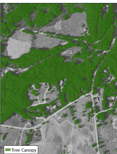
CMS: Tree Canopy Cover at 0.5-meter resolution, Vermont, 2016
National Aeronautics and Space Administration —
This dataset contains estimates of tree canopy cover presence at high resolution (0.5m) across the state of Vermont for 2016 in Cloud-Optimized GeoTIFF (*.tif)... -
Federal
NACP MCI: CO2 Emissions Inventory, Upper Midwest Region, USA., 2007
National Aeronautics and Space Administration —
This data set provides a bottom-up CO2 emissions inventory for the mid-continent region of the United States for the year 2007. The study was undertaken as part of... -
Federal
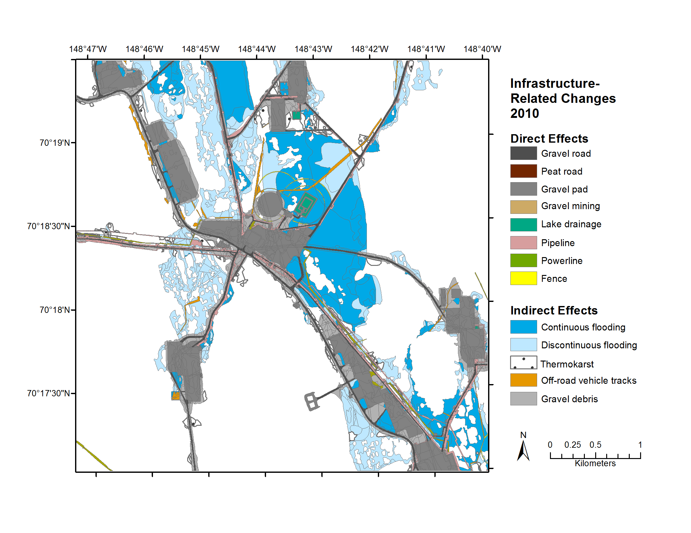
Geobotanical and Impact Map Collection for Prudhoe Bay Oilfield, Alaska, 1972-2010
National Aeronautics and Space Administration —
This data set provides a collection of maps of geoecological characteristics of areas within the Beechey Point quadrangle near Prudhoe Bay on the North slope of... -
Federal
CMS: Hourly Carbon Dioxide Estimated Using the WRF Model, North America, 2010
National Aeronautics and Space Administration —
This data set contains estimated hourly CO2 atmospheric mole fractions and meteorological observations over North America for the year 2010 at a horizontal grid... -
Federal
LBA-ECO ND-11 Forest Damage Following Reduced Impact Logging, NW Mato Grosso, Brazil
National Aeronautics and Space Administration —
Data were collected in the logging concession at the Fazenda Rohsamar in the municipality of Juruena in northwestern Mato Grosso. Estimates of damage associated with... -
Federal
Collected Data from The Boreal Ecosystem-Atmosphere Study, NASA, CD-ROM
National Aeronautics and Space Administration —
This data set provides Boreal Ecosystem-Atmosphere Study (BOREAS) project information and data collected at selected sites in the boreal forest of Saskatchewan and... -
Federal
BOREAS TGB-05 Fire History of Manitoba 1980 to 1991 in Vector Format
National Aeronautics and Space Administration —
This vector format data set covers the province of Manitoba and was produced by Forestry Canada from hand-drawn boundaries of fires on photocopies of 1:250,000 scale... -
Federal
LBA-ECO CD-01 Meteorological Data, Tapajos and Amazon Rivers, Santarem, Brazil: 2001
National Aeronautics and Space Administration —
This data set contains meteorological data collected around the confluence of the Tapajos River with the Amazon River in the Amazon Basin near Santarem, Brazil, in... -
Federal
SAFARI 2000 Soil Types, 0.5-Deg Grid (Modified Zobler)
National Aeronautics and Space Administration —
The data set consists of a southern African subset of the "Global Soil Types, 0.5-Degree Grid (Modified Zobler)" data set. Data files are provided in ASCII GRID... -
Federal
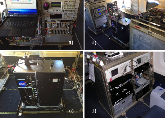
ASCENDS: Airborne CO2 LAS Retrieval, Indianapolis, IN, USA, 2014
National Aeronautics and Space Administration —
This dataset provides in situ airborne measurements of atmospheric carbon dioxide (CO2) over Indianapolis, Indiana (IN) on September 3, 2014 during the morning... -
Federal
Aircraft Flux-Filtered: Univ. Col. (FIFE)
National Aeronautics and Space Administration —
The NCAR King Air participation in FIFE-1987 and FIFE-1989 was part of a coordinated atmospheric boundary layer component which included other aircraft, surface... -
Federal
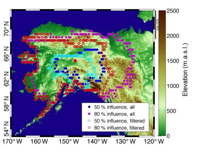
CARVE: L4 Gridded Footprints from WRF-STILT model, 2012-2016
National Aeronautics and Space Administration —
This data set provides Weather Research and Forecasting (WRF) Stochastic Time-Inverted Lagrangian Transport (STILT) Footprint data products for particle receptors... -
Federal
Canopy Photosynthesis Rates (FIFE)
National Aeronautics and Space Administration —
The Canopy Photosynthesis Data Set data were collected from five sites within the FIFE study area during July 1, 1987 through October 12, 1987. The objectives of the... -
Federal
LBA-ECO CD-02 Carbon and Oxygen Isotopes in Atmospheric CO2 in the Amazon: 1999-2004
National Aeronautics and Space Administration —
This data set reports carbon and oxygen stable isotope ratios of atmospheric carbon dioxide (CO2) collected at several forest and pasture sites and in the free... -
Federal
BOREAS TGB-05 Fire History of Manitoba 1980 to 1991 in Raster Format
National Aeronautics and Space Administration —
This raster format data set covers the province of Manitoba. The data were gridded into the AEAC projection from the original vector data. The original vector data... -
Federal
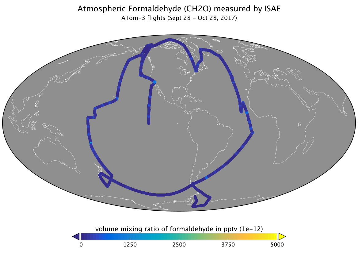
ATom: L2 Measurements of In Situ Airborne Formaldehyde (ISAF)
National Aeronautics and Space Administration —
This dataset provides the atmospheric volume mixing ratio of formaldehyde measured during airborne campaigns conducted by NASA's Atmospheric Tomography (ATom)... -
Federal
BOREAS AFM-04 Twin Otter Aircraft Flux Data
National Aeronautics and Space Administration —
The BOREAS AFM-04 team used the NRC Twin Otter aircraft in 1994 and 1996 to make measurements in the boundary layer of the fluxes of sensible and latent heat,... -
Federal
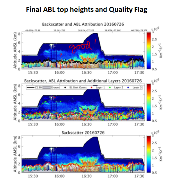
ACT-America: CPL-derived Atmospheric Boundary Layer Top Height, Eastern US, 2016-2018
National Aeronautics and Space Administration —
This dataset consists of the atmospheric boundary layer (ABL) top heights and the altitudes of the two additional aerosol layers (in km above mean sea level) derived...

Official websites use .gov
A
.gov website belongs to an official government
organization in the United States.
Secure .gov websites use HTTPS
A
lock (
) or https:// means you’ve safely connected to
the .gov website. Share sensitive information only on official,
secure websites.