
-
Federal
BOREAS AFM-08 ECMWF Hourly Surface and Upper Air Data for the SSA and NSA
National Aeronautics and Space Administration —
The BOREAS AFM-08 team focused on modeling efforts to improve the understanding of the diurnal evolution of the convective boundary layer over the boreal forest. This... -
Federal
BOREAS TE-06 NPP for the Tower Flux, Carbon Evaluation, and Auxiliary Sites
National Aeronautics and Space Administration —
The BOREAS TE-06 team collected several data sets to examine the influence of vegetation, climate, and their interactions on the major carbon fluxes for boreal forest... -
Federal
BOREAS HYD-03 Snow Water Equivalent: 1996
National Aeronautics and Space Administration —
The BOREAS HYD-03 team collected several data sets related to the hydrology of forested areas. This data set contains measurements of snow depth, snow density in 3-cm... -
Federal
Forest Carbon Stocks and Fluxes from the NFCMS, Conterminous USA, 1990-2010
National Aeronautics and Space Administration —
This dataset, derived from the National Forest Carbon Monitoring System (NFCMS), provides estimates of forest carbon stocks and fluxes in the form of aboveground... -
Federal
BOREAS AFM-03 Electra 1994 Aircraft Flux and Moving Window Data
National Aeronautics and Space Administration —
The BOREAS AFM-03 team used the NCAR Electra aircraft data to make measurements of the fluxes of momentum, sensible and latent heat, carbon dioxide, and ozone over... -
Federal
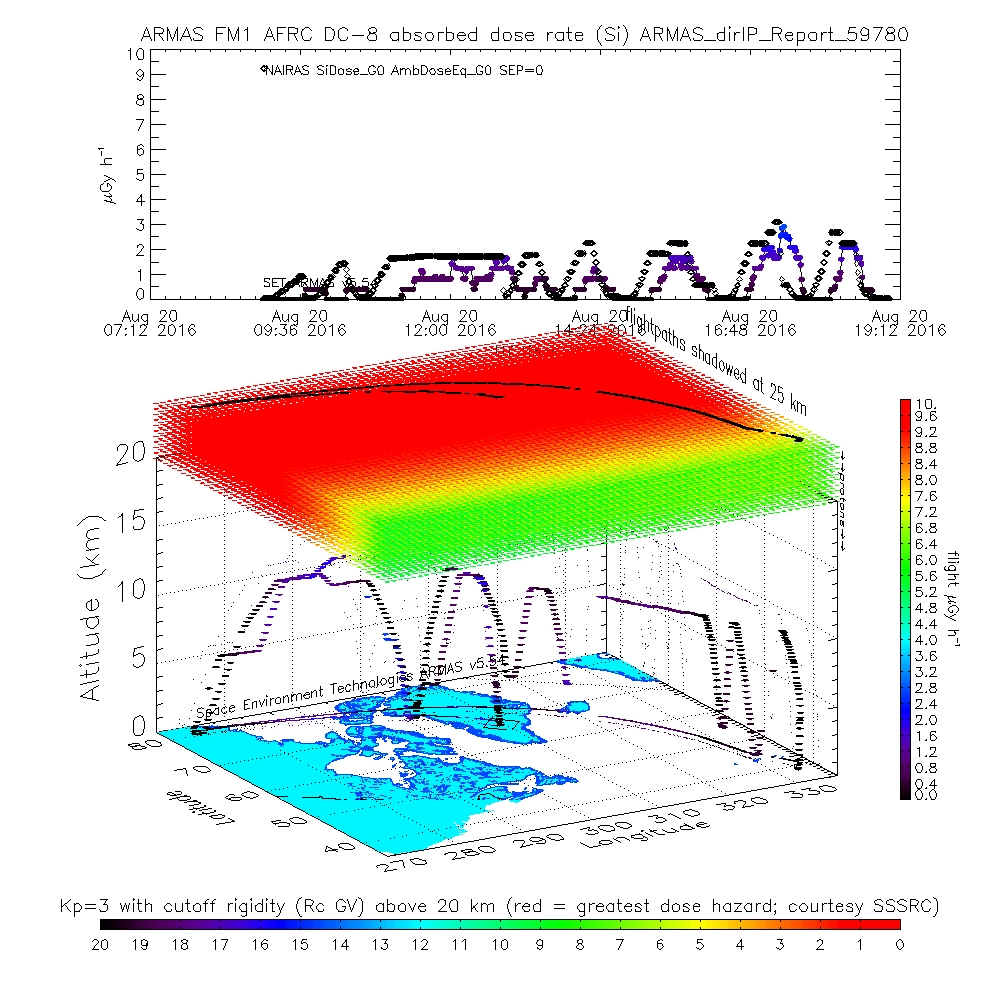
ATom: ARMAS Program Absorbed and Equivalent Radiation Dose Rates for ATom-1 Campaign
National Aeronautics and Space Administration —
This dataset contains Level 2 (L2) absorbed radiation dose rates in silicon from the Automated Radiation Measurements for Aerospace Safety (ARMAS) system along ATom... -
Federal
BOREAS AFM-06 Mean Temperature Profile Data
National Aeronautics and Space Administration —
The BOREAS AFM-06 team from the National Oceanic and Atmospheric Administration Environment Technology Laboratory (NOAA/ETL) operated a 915 MHz wind/Radio Acoustic... -
Federal
LBA-ECO LC-22 Field Validation of MODIS Deforestation Detection, Brazil, 2003-2004
National Aeronautics and Space Administration —
This data set contains field observations, corresponding GPS points, and point and polygons of deforested areas in the state of Mato Grosso, Brazil, for the period... -
Federal
LBA-ECO LC-09 Natural, Infrastructure, and Boundary Features, Amazonian Sites, Brazil
National Aeronautics and Space Administration —
This data set includes 16 zipped archives of shapefiles of cities, rivers and streams, roads, and study area boundaries of several Amazonian study sites: Altamira,... -
Federal
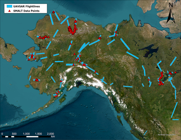
ABoVE: Soil Moisture and Active Layer Thickness in Alaska, USA and Canada, 2005-2022
National Aeronautics and Space Administration —
This dataset provides soil thaw depth and moisture measurements and dielectric properties measured by different research teams at sites in Alaska, U.S., and the... -
Federal
BOREAS RSS-17 Xylem Flux Density Measurements at the SSA-OBS Site
National Aeronautics and Space Administration —
As part of its efforts to determine environmental and phenological states from radar imagery, the BOREAS RSS-17 team collected in situ tree xylem flow measurements... -
Federal
BOREAS RSS-08 SSA IFC-3 Digitized Stereo Imagery at the OBS, OA, and OJP Sites
National Aeronautics and Space Administration —
The RSS08 team acquired stereo photography from the double-scaffold towers at the Southern Study Area (SSA) Old Black Spruce (OBS), Old Aspen (OA), and Old Jack Pine... -
Federal
BOREAS Follow-On FLX-01 NSA-OBS Tower Flux, Meteorological, and Soil Temp. Data
National Aeronautics and Space Administration —
The BOREAS Follow-On FLX-01 team collected tower flux, surface meteorological, and soil temperature data at the BOREAS NSA-OBS site continuously from March 1994... -
Federal
BOREAS TGB-04 Water and Sediment Temperature Data over the NSA-BP (Beaver Pond)
National Aeronautics and Space Administration —
The BOREAS TGB-04 team collected several data sets in support of their flux tower measurements at the NSA Beaver Pond site. This data set contains water and sediment... -
Federal
BOREAS TE-20 Soils Data over the NSA-MSA and Tower Sites in Vector Format
National Aeronautics and Space Administration —
The BOREAS TE-20 team collected several data sets for use in developing and testing models of forest ecosystem dynamics. This data set contains vector layers of soil... -
Federal
BOREAS RSS-15 SIR-C and TM Biomass and Landcover Maps of the NSA and SSA
National Aeronautics and Space Administration —
As part of BOREAS, the RSS-15 team conducted an investigation using SIR-C , X-SAR and Landsat TM data for estimating total above-ground dry biomass for the SSA and... -
Federal
Global Gridded Soil Phosphorus Distribution Maps at 0.5-degree Resolution
National Aeronautics and Space Administration —
This data set provides estimates of different forms of naturally occurring soil phosphorus (P) including labile inorganic P, organic P, occluded P, secondary mineral... -
Federal
BOREAS HYD-03 Snow Temperature Profiles
National Aeronautics and Space Administration —
The BOREAS HYD-03 team collected several data sets related to the hydrology of forested areas. This data set contains measurements of snow depth, snow density in 3-cm... -
Federal
BOREAS TE-22 Tree Ring Data
National Aeronautics and Space Administration —
The BOREAS TE-22 team collected complete tree cores at several sites in the SSA and NSA in order to perform historical growth studies and relate the information to... -
Federal
BOREAS RSS-16 Level-3b DC-8 AIRSAR CM Images
National Aeronautics and Space Administration —
The BOREAS RSS-16 team used satellite and aircraft SAR data in conjunction with various ground measurements to determine the moisture regime of the boreal forest....

Official websites use .gov
A
.gov website belongs to an official government
organization in the United States.
Secure .gov websites use HTTPS
A
lock (
) or https:// means you’ve safely connected to
the .gov website. Share sensitive information only on official,
secure websites.