
-
Federal
BOREAS HYD-03 Canopy Density Data
National Aeronautics and Space Administration —
The BOREAS HYD-03 team collected several data sets related to the hydrology of forested areas. This data set contains measurements of canopy density (closure) from a... -
Federal
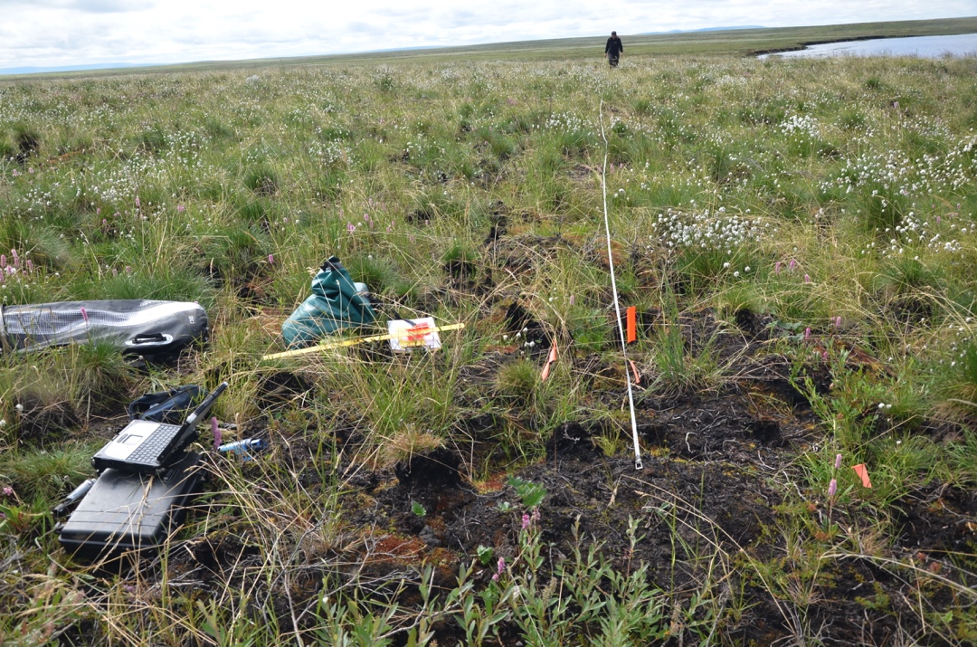
Arctic Vegetation Plots in Burned and Unburned Tundra, Alaska, 2011-2012
National Aeronautics and Space Administration —
This dataset provides environmental and vegetation data collected in late June and July of 2011 and of 2012 from study plots located in tundra fire scars and adjacent... -
Federal
BOREAS AFM-04 Twin Otter Aircraft Flux Data
National Aeronautics and Space Administration —
The BOREAS AFM-04 team used the NRC Twin Otter aircraft in 1994 and 1996 to make measurements in the boundary layer of the fluxes of sensible and latent heat,... -
Federal
Biomass Allocation and Growth Data of Seeded Plants
National Aeronautics and Space Administration —
This data set of leaf, stem, and root biomass for various plant taxa was compiled from the primary literature of the 20th century with a significant portion derived... -
Federal
SAFARI 2000 C-130 Aerosol and Meteorological Data, Dry Season 2000
National Aeronautics and Space Administration —
The Met Office C-130 research aircraft was based at Windhoek, Namibia between September 5-16, 2000, where it conducted a series of flights over Namibia as part of the... -
Federal
AirMOSS: L2 Hourly In-Ground Soil Moisture at AirMOSS Sites, 2011-2015
National Aeronautics and Space Administration —
This data set provides level 2 (L2) hourly volumetric (cm3/cm3) soil moisture profiles from in-ground sensors at seven North American sites as part of the Airborne... -
Federal
ABoVE: Study Domain and Standard Reference Grids
National Aeronautics and Space Administration —
The Arctic - Boreal Vulnerability Experiment (ABoVE) has developed two standardized spatial data products to expedite coordination of research activities and to... -
Federal
MASTER: FIREX-AQ Airborne Campaign, Western-Central USA, Summer 2019
National Aeronautics and Space Administration —
This dataset includes Level 1B (L1B) and Level 2 (L2) data products from the MODIS/ASTER Airborne Simulator (MASTER) instrument. The spectral data were collected as... -
Federal
Maps of Vegetation, NDVI, Snow and Thaw Depths: North Slope, Alaska and NWT, Canada
National Aeronautics and Space Administration —
This dataset includes vegetation cover maps, Normalized Difference Vegetation Index (NDVI) maps, snow depth and thaw depth data that were obtained as part of a... -
Federal
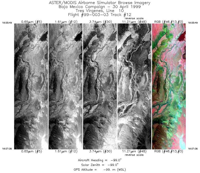
MASTER: Airborne Science, Baja Mexico-Nevada, April-May, 1999
National Aeronautics and Space Administration —
This dataset includes Level 1B (L1B) data products from the MODIS/ASTER Airborne Simulator (MASTER) instrument. The spectral data were collected during 7 flights... -
Federal
SE-590 Landscape Reflectances (OTTER)
National Aeronautics and Space Administration —
Bidirectional spectral reflectance factors of landscape elements (litter, scrubs and grasses, leaves) measured by the Spectron SE590 spectroradiometer. -
Federal
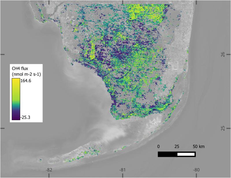
BlueFlux: Modeled Daily CO2 and CH4 Wetland Fluxes, Southern Florida, 2000-2024
National Aeronautics and Space Administration —
This dataset contains gridded estimates of carbon dioxide (CO2) and methane (CH4) fluxes at daily resolution covering the Southern Florida region from 2000 to 2024.... -
Federal
BOREAS AFM-08 ECMWF Hourly Surface and Upper Air Data for the SSA and NSA
National Aeronautics and Space Administration —
The BOREAS AFM-08 team focused on modeling efforts to improve the understanding of the diurnal evolution of the convective boundary layer over the boreal forest. This... -
Federal
LBA-ECO ND-01 Landsat 28.5-m Land Cover Time Series, Rondonia, Brazil: 1984-2010
National Aeronautics and Space Administration —
This data set provides a 27-year land cover time series of 28.5-m resolution products derived from Landsat images for 80% of Rondonia, Brazil, for the period 1984 to... -
Federal
LBA-ECO LC-21 Selective Logging Activity in the Brazilian Amazon: 1999-2002
National Aeronautics and Space Administration —
This data set provides the results of analyses of Landsat Enhanced Thematic Mapper Plus (ETM+) images for selective logging activity in the Brazilian states of Para,... -
Federal
Impacts of Wildfires on Boreal Forest Ecosystem Carbon Dynamics
National Aeronautics and Space Administration —
This dataset contains simulations of net primary production (NPP), heterotrophic respiration (RH), net ecosystem production (NEP), and soil temperature data in North... -
Federal
LBA-ECO CD-02 Carbon, Nitrogen, Oxygen Stable Isotopes in Organic Material, Brazil
National Aeronautics and Space Administration —
This data set reports the measurement of stable carbon, nitrogen, and oxygen isotope ratios in organic material (plant, litter and soil samples) in forest canopy... -
Federal
ISLSCP II Northern Hemisphere Monthly Snow Cover Extent
National Aeronautics and Space Administration —
This ISLSCP data set is derived from the National Snow and Ice Data Center (NSIDC) Northern Hemisphere EASE-Grid Weekly Snow Cover and Sea Ice Extent product which... -
Federal
ISLSCP II Carbon Dioxide Emissions from Fossil Fuels, Cement, and Gas Flaring
National Aeronautics and Space Administration —
This data set contains decadal (1950, 1960, 1970, 1980, 1990 and 1995) estimates of gridded fossil-fuel emissions, expressed in 1,000 metric tons C per year per one... -
Federal
LBA-ECO CD-17 Secondary Forest Survey, Para and Rondonia, Brazil: 2002-2003
National Aeronautics and Space Administration —
This data set provides measurements for diameter at breast height (DBH), tree height, distance from tree stems to the furthest canopy element, and a species survey of...

Official websites use .gov
A
.gov website belongs to an official government
organization in the United States.
Secure .gov websites use HTTPS
A
lock (
) or https:// means you’ve safely connected to
the .gov website. Share sensitive information only on official,
secure websites.