
-
Federal
BOREAS TE-06 NPP for the Tower Flux, Carbon Evaluation, and Auxiliary Sites
National Aeronautics and Space Administration —
The BOREAS TE-06 team collected several data sets to examine the influence of vegetation, climate, and their interactions on the major carbon fluxes for boreal forest... -
Federal
BOREAS TE-07 Dendrology Data
National Aeronautics and Space Administration —
The BOREAS TE-07 team collected data sets in support of its efforts to characterize and interpret information on the sapflow and dendrology of boreal vegetation. This... -
Federal
BOREAS HYD-09 Streamflow Data
National Aeronautics and Space Administration —
These streamflow data were collected by the HYD-09 science team to support its research into meltwater supply to the soil during the spring melt period. These data... -
Federal
BOREAS HYD-03 Canopy Density Data
National Aeronautics and Space Administration —
The BOREAS HYD-03 team collected several data sets related to the hydrology of forested areas. This data set contains measurements of canopy density (closure) from a... -
Federal
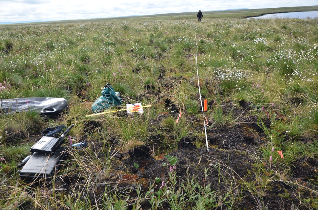
Arctic Vegetation Plots in Burned and Unburned Tundra, Alaska, 2011-2012
National Aeronautics and Space Administration —
This dataset provides environmental and vegetation data collected in late June and July of 2011 and of 2012 from study plots located in tundra fire scars and adjacent... -
Federal
BOREAS AFM-04 Twin Otter Aircraft Flux Data
National Aeronautics and Space Administration —
The BOREAS AFM-04 team used the NRC Twin Otter aircraft in 1994 and 1996 to make measurements in the boundary layer of the fluxes of sensible and latent heat,... -
Federal
BOREAS AFM-05 Level-1 Upper Air Network Data, R1
National Aeronautics and Space Administration —
The BOREAS AFM-05 team collected and processed data from the numerous radiosonde flights during the project. The goals of the AFM-05 team were to provide large scale... -
Federal
BOREAS AFM-02 Wyoming King Air 1994 Aircraft Sounding Data
National Aeronautics and Space Administration —
The BOREAS AFM-02 team used the University of Wyoming King Air aircraft during IFCs 1, 2, and 3 in 1994 to collected pass-by-pass fluxes (and many other statistics)... -
Federal
Russian Boreal Forest Disturbance Maps Derived from Landsat Imagery, 1984-2000
National Aeronautics and Space Administration —
This data set provides Boreal forest disturbance maps at 30-m resolution for 55 selected sites across Northern Eurasia within the Russian Federation. Disturbance... -
Federal
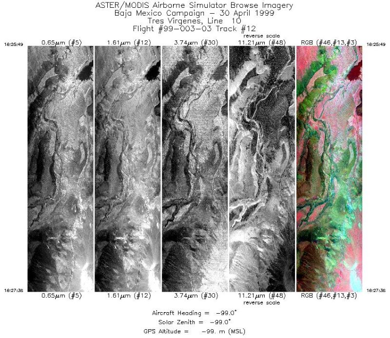
MASTER: Airborne Science, Baja Mexico-Nevada, April-May, 1999
National Aeronautics and Space Administration —
This dataset includes Level 1B (L1B) data products from the MODIS/ASTER Airborne Simulator (MASTER) instrument. The spectral data were collected during 7 flights... -
Federal
SE-590 Field-Meas. Reflectances (OTTER)
National Aeronautics and Space Administration —
Spectral reflectance measurements made by Spectron SE590 instruments in the context of validation of geometric-optical BRDF models. -
Federal
BOREAS AFM-08 ECMWF Hourly Surface and Upper Air Data for the SSA and NSA
National Aeronautics and Space Administration —
The BOREAS AFM-08 team focused on modeling efforts to improve the understanding of the diurnal evolution of the convective boundary layer over the boreal forest. This... -
Federal
LBA-HMET PC-06 ECMWF Modeled Precipitation and Surface Flux, Rondonia, Brazil: 1999
National Aeronautics and Space Administration —
This data set provides the mean diurnal cycle of precipitation, near-surface thermodynamics, and surface fluxes generated from short-term forecasts from the European... -
Federal
LBA-ECO LC-07 Aquatic Marcophyte Biomass, Monte Alegre Lake, Para, Brazil: 2003-2004
National Aeronautics and Space Administration —
This data set reports measurements of aquatic macrophyte biomass, phenology, leaf characteristics, and length and diameter of stems of both submerged and unsubmerged... -
Federal
LBA-ECO TG-07 Soil Trace Gas Fluxes km 67 Seca-Floresta Site, Tapajos National Forest
National Aeronautics and Space Administration —
Trace gas fluxes of carbon dioxide, methane, nitrous oxide, and nitric oxide (CO2, CH4, N2O, and NO) from surface soil were measured manually in an undisturbed forest... -
Federal
Delta-X: UAVSAR L1 Single Look Complex (SLC) Stack Products, MRD, Louisiana, 2021
National Aeronautics and Space Administration —
This dataset contains UAVSAR Level 1 (L1) Single Look Complex (SLC) stack products for Delta-X flight lines acquired during 2021-03-27 to 2021-04-18 (spring) and... -
Federal
BOREAS TE-09 in situ Understory Spectral Reflectance within the NSA
National Aeronautics and Space Administration —
Spectral reflectance of the forest understory at the ground level, in three boreal forest sites of Northern Manitoba (56 degrees N latitude and 98 degrees W... -
Federal
BOREAS AFM-06 Boundary Layer Height Data
National Aeronautics and Space Administration —
The BOREAS AFM-06 team from the National Oceanic and Atmospheric Administration Environment Technology Laboratory (NOAA/ETL) operated a 915 MHz wind/Radio Acoustic... -
Federal
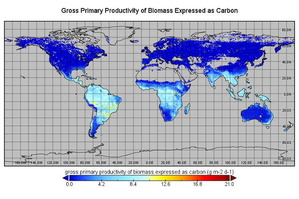
Global Monthly GPP from an Improved Light Use Efficiency Model, 1982-2016
National Aeronautics and Space Administration —
This dataset provides global monthly average gross primary productivity (GPP; g carbon/m2/d) modeled at 8 km spatial resolution for each of the 35 years from... -
Federal
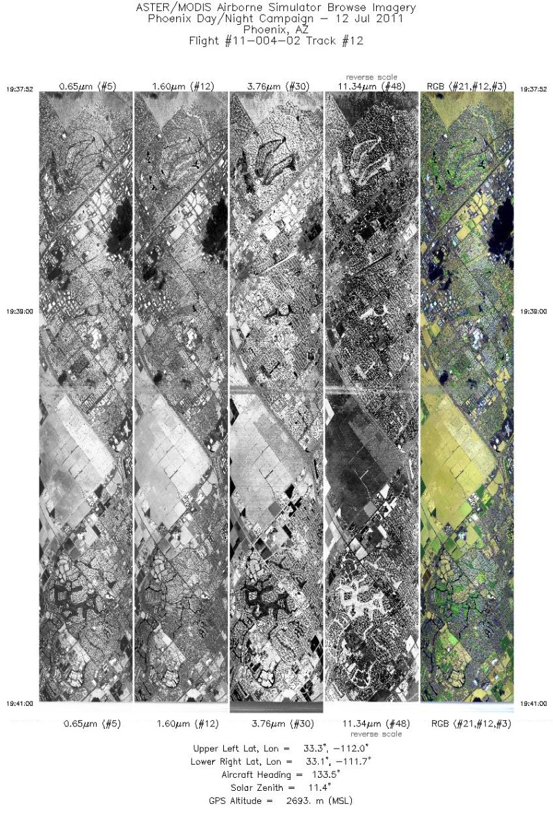
MASTER: Heat Island Airborne Study, Phoenix, Arizona, 2011
National Aeronautics and Space Administration —
This dataset includes Level 1B (L1B) data products from the MODIS/ASTER Airborne Simulator (MASTER) instrument. The spectral data were collected during five flights...

Official websites use .gov
A
.gov website belongs to an official government
organization in the United States.
Secure .gov websites use HTTPS
A
lock (
) or https:// means you’ve safely connected to
the .gov website. Share sensitive information only on official,
secure websites.