
-
Federal
ABoVE: Landsat-derived Burn Scar dNBR across Alaska and Canada, 1985-2015
National Aeronautics and Space Administration —
This dataset contains differenced Normalized Burned Ratio (dNBR) at 30-m resolution calculated for burn scars from fires that occurred within the Arctic Boreal and... -
Federal
ABoVE: Wetland Vegetation Classification for Peace-Athabasca Delta, Canada, 2019
National Aeronautics and Space Administration —
This dataset contains land cover classification focused on water and wetland vegetation communities over the Peace-Athabasca Delta, Canada. Four classification maps... -
Federal
Pre-ABoVE: Active Layer Thickness and Soil Water Content, Barrow, Alaska, 2013
National Aeronautics and Space Administration —
This data set provides estimates of Active Layer Thickness (ALT) determined with ground-based measurements, and calculated soil volumetric water content (VWC) at four... -
Federal
Gamma Ray Data: Peck (FIFE)
National Aeronautics and Space Administration —
Airborne soil moisture measurement is based on the difference between natural terrestrial gamma radiation flux measured for comparatively wet and dry soils. The... -
Federal
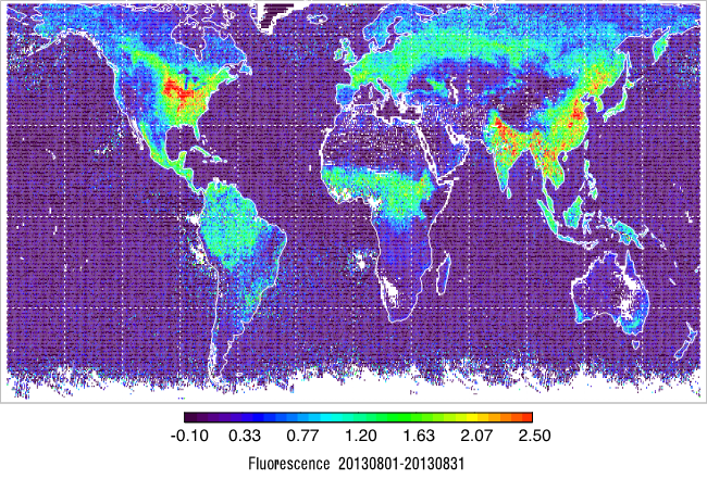
High Resolution Global Contiguous SIF Estimates from OCO-2 SIF and MODIS, Version 2
National Aeronautics and Space Administration —
This dataset provides spatially-contiguous global mean daily solar-induced chlorophyll fluorescence (SIF) estimates at 0.05 degree (approximately 5 km at the equator)... -
Federal
CMS: Global 0.5-deg Wetland Methane Emissions and Uncertainty (WetCHARTs v1.3.3)
National Aeronautics and Space Administration —
This dataset provides global monthly wetland methane (CH4) emissions estimates at 0.5 by 0.5-degree resolution for the period 2001-01-01 to 2022-08-31 that were... -
Federal
Amazon River Basin Precipitation, 1972-1992
National Aeronautics and Space Administration —
The Amazon River Basin precipitation grids were derived from data which was collected daily by the gauging network operated by the Divisao Nacional de Aguas e Energia... -
Federal
Global 30-Year Mean Monthly Climatology, 1901-1960 (New et al.)
National Aeronautics and Space Administration —
This is a data set of 30-year mean monthly surface climate data over global land areas, excluding Antarctica, for the period 1901-1960. The data set is gridded at 0.5... -
Federal
GEDI L3 Gridded Land Surface Metrics, Version 1
National Aeronautics and Space Administration —
This dataset provides Global Ecosystem Dynamics Investigation (GEDI) Level 3 (L3) gridded mean canopy height, standard deviation of canopy height, mean ground... -
Federal
ISLSCP II EDGAR 3 Gridded Greenhouse and Ozone Precursor Gas Emissions
National Aeronautics and Space Administration —
The EDGAR (Emission Database for Global Atmospheric Research) database project is a comprehensive task carried out jointly by the National Institute for Public Health... -
Federal
Lund-Potsdam-Jena Wetland Hydrology and Methane DGV Model (LPJ-WHyMe v1.3.1)
National Aeronautics and Space Administration —
This model product provides the Fortran 77 source code for the Lund-Potsdam-Jena (LPJ) Wetland Hydrology and Methane Dynamic Global Vegetation Model (LPJ-WHyMe... -
Federal
ATom: L2 In Situ Measurements from NOAA Nitrogen Oxides and Ozone (NOyO3) Instrument
National Aeronautics and Space Administration —
This dataset provides in situ concentrations of nitric oxide (NO), nitrogen dioxide (NO2), total reactive nitrogen oxides (NOy), and ozone (O3) measured by the NOAA... -
Federal
MASTER: FireSense, California and Southern US, Spring 2025
National Aeronautics and Space Administration —
This dataset includes Level 1B (L1B) and Level 2 (L2) data products from the MODIS/ASTER Airborne Simulator (MASTER) instrument. The spectral data were collected as... -
Federal
Gridded GEDI Vegetation Structure Metrics and Biomass Density at Multiple Resolutions
National Aeronautics and Space Administration —
This dataset consists of near-global, analysis-ready, multi-resolution gridded vegetation structure metrics derived from NASA Global Ecosystem Dynamics Investigation... -
Federal
MASTER: Geological Earth Mapping Experiment (GEMx), California-Arizona, Summer 2023
National Aeronautics and Space Administration —
This dataset includes Level 1B (L1B) and Level 2 (L2) data products from the MODIS/ASTER Airborne Simulator (MASTER) instrument. The spectral data were collected... -
Federal
MASTER: Costa Rica Airborne Research and Technology Applications (CARTA), 2005
National Aeronautics and Space Administration —
This dataset includes Level 1B (L1B) data products from the MODIS/ASTER Airborne Simulator (MASTER) instrument. The spectral data were collected during 23 flights... -
Federal
ABoVE: Permafrost Measurements and Distribution Across the Y-K Delta, Alaska, 2016
National Aeronautics and Space Administration —
This dataset provides field observations of thaw depth and dominant vegetation types, a LiDAR-derived elevation map, and permafrost distribution and probability maps... -
Federal
NWS Daily Climatology Data: 1990 (SNF)
National Aeronautics and Space Administration —
Weather data were collected by the National Weather Service in International Falls, Minnesota. International Falls is about 80 miles from the SNF, but the weather... -
Federal
Soil Thermal Conductivity Data (FIFE)
National Aeronautics and Space Administration —
The purpose of the 1989 FIFE soil properties investigation was to obtain a description of the thermal properties of the soils within the FIFE study area. Soil thermal... -
Federal
L2 Daily Solar-Induced Fluorescence (SIF) from MetOp-B GOME-2, 2013-2021
National Aeronautics and Space Administration —
This dataset provides Level 2 (L2) Solar-Induced Fluorescence (SIF) of chlorophyll estimates derived from the Global Ozone Monitoring Experiment 2 (GOME-2) instrument...

Official websites use .gov
A
.gov website belongs to an official government
organization in the United States.
Secure .gov websites use HTTPS
A
lock (
) or https:// means you’ve safely connected to
the .gov website. Share sensitive information only on official,
secure websites.