
-
Federal
Aquarius Official Release Level 3 Ancillary Reynolds Sea Surface Temperature Standard Mapped Image Descending Mission Cumulative Data V5.0 recent views
National Aeronautics and Space Administration —
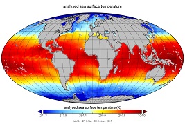
Aquarius Level 3 ancillary sea surface temperature (SST) standard mapped image data are the ancillary SST data used in the Aquarius calibration for salinity... -
Federal
GFZ TELLUS GRACE Level-3 Monthly Ocean Bottom Pressure Anomaly Release 6.0 version 04 recent views
National Aeronautics and Space Administration —
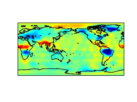
The monthly ocean bottom pressure anomaly grids are given as equivalent water thickness changes derived from GRACE & GRACE-FO time-variable gravity observations... -
Federal
GHRSST Level 3C North Atlantic Regional (NAR) subskin Sea Surface Temperature from Metop/AVHRR (GDS V2) produced by OSI SAF recent views
National Aeronautics and Space Administration —
A Group for High Resolution Sea Surface Temperature (GHRSST) dataset for the North Atlantic Region (NAR) derived from the Advanced Very High Resolution Radiometer... -
Federal
Aquarius Official Release Level 3 Sea Surface Salinity Standard Mapped Image Monthly Climatology Data V5.0 recent views
National Aeronautics and Space Administration —
Aquarius Level 3 sea surface salinity (SSS) standard mapped image data contains gridded 1 degree spatial resolution SSS averaged over daily, 7 day, monthly, and... -
Federal
GHRSST Level 4 MW_OI Global Foundation Sea Surface Temperature analysis version 5.1 from REMSS recent views
National Aeronautics and Space Administration —
A Group for High Resolution Sea Surface Temperature (GHRSST) global Level 4 sea surface temperature analysis produced daily on a 0.25-degree grid at Remote Sensing... -
Federal
ECCO Ocean Density, Stratification, and Hydrostatic Pressure - Daily Mean 0.5 Degree (Version 4 Release 4) recent views
National Aeronautics and Space Administration —
This dataset contains daily-averaged ocean density, stratification, and hydrostatic pressure interpolated to a regular 0.5-degree grid from the ECCO Version 4... -
Federal
MODIS Terra Level 3 SST Thermal IR Monthly 9km Daytime V2019.0 NGDA recent views
National Aeronautics and Space Administration —
Day and night spatially gridded global NASA skin sea surface temperature (SST) products from the Moderate-resolution Imaging Spectroradiometer (MODIS) onboard the... -
Federal
MODIS Terra Level 3 SST Thermal IR Annual 9km Daytime V2019.0 NGDA recent views
National Aeronautics and Space Administration —
TDay and night spatially gridded (L3) global NASA skin sea surface temperature (SST) products from the Moderate-resolution Imaging Spectroradiometer (MODIS) onboard... -
Federal
MODIS Terra Level 3 SST Thermal IR Monthly 4km Nighttime V2019.0 NGDA recent views
National Aeronautics and Space Administration —
Day and night spatially gridded global NASA skin sea surface temperature (SST) products from the Moderate-resolution Imaging Spectroradiometer (MODIS) onboard the... -
Federal
ECCO Ocean Three-Dimensional Momentum Tendency - Monthly Mean llc90 Grid (Version 4 Release 4) recent views
National Aeronautics and Space Administration —
This dataset provides monthly-averaged ocean three-dimensional momentum tendency on the native Lat-Lon-Cap 90 (LLC90) model grid from the ECCO Version 4 Release 4... -
Federal
RSS SMAP Level 2C Sea Surface Salinity V5.0 Validated Dataset recent views
National Aeronautics and Space Administration —
The version 5.0 SMAP-SSS, level 2C product contains the fourth release of the validated sea surface salinity orbital/swath data from the NASA Soil Moisture Active... -
Federal
ECCO Ocean Density, Stratification, and Hydrostatic Pressure - Monthly Mean 0.5 Degree (Version 4 Release 4) recent views
National Aeronautics and Space Administration —
This dataset contains monthly-averaged ocean density, stratification, and hydrostatic pressure interpolated to a regular 0.5-degree grid from the ECCO Version 4... -
Federal
SWOT Level 2 Water Mask Pixel Cloud Data Product, Version 2.0 recent views
National Aeronautics and Space Administration —
Point cloud of water mask pixels (“pixel cloud”) with geolocated heights, backscatter, geophysical fields, and flags. Point cloud over tile (approx 64x64 km2); half... -
Federal
OPERA Dynamic Surface Water Extent from Harmonized Landsat Sentinel-2 provisional product (Version 1) recent views
National Aeronautics and Space Administration —
This dataset contains Level-3 Dynamic OPERA provisional surface water extent product version 1. The data are provisional surface water extent observations beginning... -
Federal
ECCO Ocean Temperature and Salinity - Daily Mean 0.5 Degree (Version 4 Release 4) recent views
National Aeronautics and Space Administration —
This dataset contains daily-averaged ocean potential temperature and salinity interpolated to a regular 0.5-degree grid from the ECCO Version 4 revision 4 (V4r4)... -
Federal
GHRSST Level 4 MUR Global Foundation Sea Surface Temperature Analysis (v4.1) NGDA recent views
National Aeronautics and Space Administration —
A Group for High Resolution Sea Surface Temperature (GHRSST) Level 4 sea surface temperature analysis produced as a retrospective dataset (four day latency) and near-... -
Federal
Global Mean Sea Level Trend from Integrated Multi-Mission Ocean Altimeters TOPEX/Poseidon, Jason-1, OSTM/Jason-2, and Jason-3 Version 5.1 recent views
National Aeronautics and Space Administration —
This dataset contains the Global Mean Sea Level (GMSL) trend generated from the Integrated Multi-Mission Ocean Altimeter Data for Climate Research Version 5.1. The... -
Federal
SPURS-2 shipboard X-band radar backscatter images for the 2016 E. Tropical Pacific field campaign recent views
National Aeronautics and Space Administration —
The SPURS-2 X-band marine navigation radar image dataset was collected from the ship during both the 2016 and 2017 cruises. The dataset consists of screenshots of... -
Federal
SWOT Simulated Level 2 North America Continent KaRIn High Rate Water Mask Pixel Cloud Product Version 1.0 recent views
National Aeronautics and Space Administration —
This dataset includes simulated water surface elevations that resemble the Ka-band Interferometer (KaRIn) measurements by the Surface Water and Ocean Topography...

Official websites use .gov
A
.gov website belongs to an official government
organization in the United States.
Secure .gov websites use HTTPS
A
lock (
) or https:// means you’ve safely connected to
the .gov website. Share sensitive information only on official,
secure websites.