
-
Federal
Carbon Monitoring System Carbon Flux Ocean Prior L4 V3 (CMSFluxOceanPrior)
National Aeronautics and Space Administration —
This dataset provides the Prior for the Carbon Flux for Ocean.The NASA Carbon Monitoring System (CMS) is designed to make significant contributions in characterizing,... -
Federal
GPM MHS on NOAA19 (GPROF) Radiometer Precipitation Profiling L3 1 month 0.25 degree x 0.25 degree V07 (GPM_3GPROFNOAA19MHS) at GES DISC
National Aeronautics and Space Administration —
Version 07 is the current version of the data set. Older versions will no longer be available and have been superseded by Version 07. 3GPROF products provide global... -
Federal
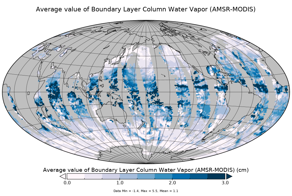
AMSR-MODIS Boundary Layer Water Vapor L3 Daily 1 degree x 1 degree V2 (AMDBLWV) at GES DISC
National Aeronautics and Space Administration —
Version 2 is the current version of this dataset. Version 2 uses an improved methodology to screen out high clouds.This data set provides an estimate the marine... -
Federal
Sounder SIPS: Suomi NPP CrIMSS Level 3 Comprehensive Quality Control Gridded Daily CHART Normal Spectral Resolution V1
National Aeronautics and Space Administration —
The objective of this limited edition data collection is to examine products generated by the Climate Heritage AIRS Retrieval Technique (CHART) algorithm to analyze... -
Federal
GPM ATMS on NOAA-21 (GPROF) Climate-based Radiometer Precipitation Profiling L2A 1.5 hours 17 km V07 (GPM_2AGPROFNOAA21ATMS_CLIM) at GES DISC
National Aeronautics and Space Administration —
Version 07 is the current version of the data set. The "CLIM" products differ from their "regular" counterparts (without the "CLIM" in the name) by the ancillary data... -
Federal
Aqua/AIRS L3 Daily Standard Physical Retrieval (AIRS+AMSU) 1 degree x 1 degree V7.0 at GES DISC
National Aeronautics and Space Administration —
The Atmospheric Infrared Sounder (AIRS) is a grating spectrometer (R = 1200) aboard the second Earth Observing System (EOS) polar-orbiting platform, EOS Aqua. In... -
Federal
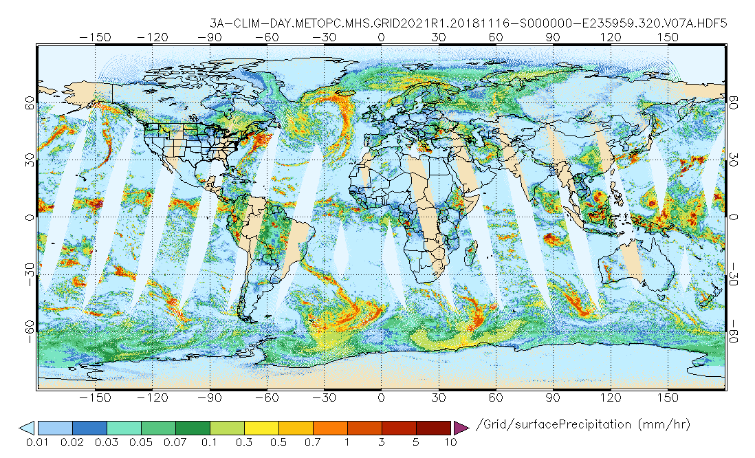
GPM MHS on METOP-C (GPROF) Climate-based Radiometer Precipitation Profiling L3 1 day 0.25 degree x 0.25 degree V07 (GPM_3GPROFMETOPCMHS_DAY_CLIM) at GES DISC
National Aeronautics and Space Administration —
Version 07 is the current version of the data set. Older versions are no longer available and have been superseded by Version 07. The "CLIM" products differ from... -
Federal
GPM SSMI on F15 (GPROF) Climate-based Radiometer Precipitation Profiling L3 1 month 0.25 degree x 0.25 degree V07 (GPM_3GPROFF15SSMI_CLIM) at GES DISC
National Aeronautics and Space Administration —
Version 07 is the current version of the data set. Older versions will no longer be available and have been superseded by Version 07. The "CLIM" products differ from... -
Federal
Sounder SIPS: Suomi NPP CrIMSS Level 3 Comprehensive Quality Control Gridded Monthly CHART Normal Spectral Resolution V1
National Aeronautics and Space Administration —
The objective of this limited edition data collection is to examine products generated by the Climate Heritage AIRS Retrieval Technique (CHART) algorithm to analyze... -
Federal
OCO-2 Level 2 geolocated XCO2 retrievals results, physical model, Retrospective Processing V10r (OCO2_L2_Standard) at GES DISC
National Aeronautics and Space Administration —
Version 10r is the current version of the data set. Older versions will no longer be available and are superseded by Version 10r.In early 2021, the OCO Team... -
Federal
TROPESS CrIS-SNPP L2 for Delhi Megacity, Summary Product V1 (TRPSYL2ALLCRSMGDEL) at GES DISC
National Aeronautics and Space Administration —
The TROPESS CrIS-SNPP L2 for Delhi Megacity, Summary Product contains the vertical distribution of six retrieved atmospheric gases (CH4, CO, HDO, NH3, O3 and PAN),... -
Federal
WLDAS Noah-MP 3.6 Land Surface Model L4 Daily 0.01 degree x 0.01 degree Version D1.0 (WLDAS_NOAHMP001_DA1) at GES DISC
National Aeronautics and Space Administration —
The Western Land Data Assimilation System (WLDAS), developed at Goddard Space Flight Center (GSFC) and funded by the NASA Western Water Applications Office, provides... -
Federal
GLDAS Noah Land Surface Model L4 3 hourly 0.25 x 0.25 degree V2.0 (GLDAS_NOAH025_3H) at GES DISC
National Aeronautics and Space Administration —
NASA Global Land Data Assimilation System Version 2 (GLDAS-2) has three components: GLDAS-2.0, GLDAS-2.1, and GLDAS-2.2. GLDAS-2.0 is forced entirely with the... -
Federal
Sounder SIPS: Suomi NPP CrIMSS Level 2 CLIMCAPS Normal Spectral Resolution: Atmospheric state at Standard Pressure Levels derived from CLIMCAPS V2.1 (SNDRSNIML2PLEVCPSN) at GES DISC
National Aeronautics and Space Administration —
The CLIMCAPS (Community Long-term Infrared Microwave Coupled Product System) algorithm is used to analyze data from the Cross-track Infrared Sounder/Advanced... -
Federal
GPM SSMIS on F18 (GPROF) Climate-based Radiometer Precipitation Profiling L3 1 day 0.25 degree x 0.25 degree V07 (GPM_3GPROFF18SSMIS_DAY_CLIM) at GES DISC
National Aeronautics and Space Administration —
Version 07 is the current version of the data set. Older versions will no longer be available and have been superseded by Version 07. The 'CLIM' products differ from... -
Federal
GPM SSMI on F15 (GPROF) Climate-based Radiometer Precipitation Profiling L3 1 day 0.25 degree x 0.25 degree V07 (GPM_3GPROFF15SSMI_DAY_CLIM) at GES DISC
National Aeronautics and Space Administration —
Version 07 is the current version of the data set. Older versions will no longer be available and have been superseded by Version 07. The "CLIM" products differ from... -
Federal
GPM ATMS on NOAA-20 (GPROF) Radiometer Precipitation Profiling L2A 1.5 hours 17 km V07 (GPM_2AGPROFNOAA20ATMS) at GES DISC
National Aeronautics and Space Administration —
Version 07 is the current version of the data set. The 2AGPROF (also known as, GPM GPROF (Level 2)) algorithm retrieves consistent precipitation and related science... -
Federal
GLDAS Catchment Land Surface Model L4 monthly 1.0 x 1.0 degree Early Product V2.1 (GLDAS_CLSM10_M_EP) at GES DISC
National Aeronautics and Space Administration —
NASA Global Land Data Assimilation System Version 2 (GLDAS-2) has three components: GLDAS-2.0, GLDAS-2.1, and GLDAS-2.2. GLDAS-2.0 is forced entirely with the... -
Federal
Sentinel-5P TROPOMI Tropospheric Ozone Column V2 (S5P_L2__O3_TCL) at GES DISC
National Aeronautics and Space Administration —
Starting from July 13th in 2020, five Sentinel-5P TROPOMI level-2 products including total and tropospheric column ozone, sulfur dioxide, CLOUD, and formaldehyde have... -
Federal
GPM ATMS on NOAA-21 Common Calibrated Brightness Temperatures L1C 1.5 hours 17 km V07 (GPM_1CNOAA21ATMS) at GES DISC
National Aeronautics and Space Administration —
Version 07 is the current version of the data set. Older versions will no longer be available and have been superseded by Version 07.1CATMS contains common calibrated...

Official websites use .gov
A
.gov website belongs to an official government
organization in the United States.
Secure .gov websites use HTTPS
A
lock (
) or https:// means you’ve safely connected to
the .gov website. Share sensitive information only on official,
secure websites.