
-
Federal
THIR/Nimbus-7 Level 1 Cloud Data for SBUV/TOMS V001 (THIRN7L1BCLT) at GES DISC
National Aeronautics and Space Administration —
THIRN7L1BCLT is the Nimbus-7 Temperature-Humidity Infrared Radiometer (THIR) Level 1 Cloud Data for SBUV/TOMS (BCLT) product and contains total cloud amounts;... -
Federal
MLS/Aura Level 3 Daily Binned Ozone (O3) Mixing Ratio on Zonal and Similar Grids V004 (ML3DZO3) at GES DISC
National Aeronautics and Space Administration —
ML3DZO3 is the EOS Aura Microwave Limb Sounder (MLS) daily binned on zonal and assorted vertical grids product for ozone (O3) derived from radiances measured by the... -
Federal
Sentinel-6A EUMETSAT GNSS-RO Non-Time-Critical Level 1B V1 (S6A_RO_1B_BND_____) at GES DISC
National Aeronautics and Space Administration —
This dataset provides the L1B Global Navigation Satellite System (GNSS) Radio-Occultation (RO) Non-Time-Critical (NTC) retrieval generated by European Organisation... -
Federal
TROPESS CrIS-SNPP L2 for Mexico City Megacity, Summary Product V1 (TRPSYL2ALLCRSMGMEX) at GES DISC
National Aeronautics and Space Administration —
The TROPESS CrIS-SNPP L2 for Mexico City Megacity, Summary Product contains the vertical distribution of six retrieved atmospheric gases (CH4, CO, HDO, NH3, O3 and... -
Federal
MLS/Aura Level 3 Daily Binned Temperature on Zonal and Similar Grids V005 (ML3DZT) at GES DISC
National Aeronautics and Space Administration —
ML3DZT is the EOS Aura Microwave Limb Sounder (MLS) daily binned on zonal and assorted vertical grids product for temperature derived from radiances measured by the... -
Federal
OMI/Aura Sulfur Dioxide (SO2) Total Column Daily L3 1 day Best Pixel in 0.25 degree x 0.25 degree V3 (OMSO2e) at GES DISC
National Aeronautics and Space Administration —
The OMI science team produces this Level-3 Aura/OMI Global OMSO2e Data Products (0.25 degree Latitude/Longitude grids). In this Level-3 daily global SO2 data product,... -
Federal
NOAA20 VIIRS High Resolution Level 3 monthly aerosol data, 0.1x0.1 degree grid Version 001 (AER_DBDT_M10KM_L3_VIIRS_NOAA20) at GES DISC
National Aeronautics and Space Administration —
This High-Resolution (0.1 x 0.1 degree) Level 3 monthly Aerosol Optical Depth (AOD) product is generated by combining two Visible Infrared Imaging Radiometer Suite... -
Federal
NOAA20 VIIRS High Resolution Level 3 daily aerosol data, 0.1x0.1 degree grid Version 001 (AER_DBDT_D10KM_L3_VIIRS_NOAA20) at GES DISC
National Aeronautics and Space Administration —
This High-Resolution (0.1 x 0.1 degree) Level 3 daily Aerosol Optical Depth (AOD) product is generated by combining two Visible Infrared Imaging Radiometer Suite... -
Federal
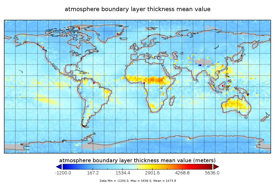
GPS Radio Occultation Boundary Layer Depth Seasonal L3 V2 (GPSROZPBLS) at GES DISC
National Aeronautics and Space Administration —
This dataset provides a seasonal average climatology of global planetary boundary layer (PBL) height derived from COSMIC/FORMOSAT-3, TerraSAR-X, KOMPSAT-5, and PAZ... -
Federal
GLDAS Catchment Land Surface Model L4 daily 0.25 x 0.25 degree GRACE-DA1 V2.2 (GLDAS_CLSM025_DA1_D) at GES DISC
National Aeronautics and Space Administration —
NASA Global Land Data Assimilation System Version 2 (GLDAS-2) has three components: GLDAS-2.0, GLDAS-2.1, and GLDAS-2.2. GLDAS-2.0 is forced entirely with the... -
Federal
TROPESS CrIS-SNPP L2 for Tokyo Megacity, Standard Product V1 (TRPSDL2ALLCRSMGTOK) at GES DISC
National Aeronautics and Space Administration —
The TROPESS CrIS-SNPP L2 for Tokyo Megacity, Standard Product contains the vertical distribution of seven retrieved atmospheric gases (CH4, CO, H2O, HDO, NH3, O3 and... -
Federal
TROPESS CrIS-SNPP L2 for Lagos Megacity, Standard Product V1 (TRPSDL2ALLCRSMGLAG) at GES DISC
National Aeronautics and Space Administration —
The TROPESS CrIS-SNPP L2 for Lagos Megacity, Standard Product contains the vertical distribution of seven retrieved atmospheric gases (CH4, CO, H2O, HDO, NH3, O3 and... -
Federal
TOMS Earth Probe UV Aerosol Index Monthly L3 Global 1 deg x 1.25 deg Lat/Lon Grid V008 (TOMSEPL3maer) at GES DISC
National Aeronautics and Space Administration —
This Earth Probe (EP) Total Ozone Mapping Spectrometer (TOMS) version 8 monthly averaged global gridded data product contains UV aerosol index values. The data are... -
Federal
OCO-3 Level 2 meteorological parameters interpolated from global assimilation model for each sounding, Retrospective Processing V10r (OCO3_L2_Met) at GES DISC
National Aeronautics and Space Administration —
Version 10r is the current version of the data set. Older versions will no longer be available and are superseded by Version 10r.The Orbiting Carbon Observatory -3... -
Federal
OCO-3 Level 2 spatially ordered geolocated retrievals screened using the A-band Preprocessor, Retrospective Processing V10r (OCO3_L2_ABand) at GES DISC
National Aeronautics and Space Administration —
Version 10r is the current version of the data set. Older versions will no longer be available and are superseded by Version 10r.The Orbiting Carbon Observatory -3... -
Federal
OCO-3 Level 2 geolocated XCO2 retrievals results, physical model, Retrospective Processing V11r (OCO3_L2_Standard) at GES DISC
National Aeronautics and Space Administration —
Version 11r is the current version of the data set. Older versions will no longer be available and are superseded by Version 11r.The Orbiting Carbon Observatory -3... -
Federal
Sentinel-5P TROPOMI Radiance product band 8 (SWIR detector) L1B 5.5km x 7km V1 (S5P_L1B_RA_BD8_HiR) at GES DISC
National Aeronautics and Space Administration —
Starting from August 6th in 2019, Sentinel-5P TROPOMI along-track high spatial resolution (~5.5km at nadir) has been implemented.For data before August 6th of 2019,... -
Federal
Sentinel-5P TROPOMI Aerosol Layer Height 1-Orbit L2 5.5km x 3.5km V2 (S5P_L2__AER_LH_HiR) at GES DISC
National Aeronautics and Space Administration —
Starting from August 6th in 2019, Sentinel-5P TROPOMI along-track high spatial resolution (~5.5km at nadir) has been implemented.For data before August 6th of 2019,... -
Federal
Sentinel-5P TROPOMI Carbon Monoxide CO Column 1-Orbit L2 5.5km x 7km V2 (S5P_L2__CO_____HiR) at GES DISC
National Aeronautics and Space Administration —
Starting from August 6th in 2019, Sentinel-5P TROPOMI along-track high spatial resolution (~5.5km at nadir) has been implemented.For data before August 6th of 2019,... -
Federal
Sentinel-5P TROPOMI Aerosol Index 1-Orbit L2 5.5km x 3.5km V1 (S5P_L2__AER_AI_HiR) at GES DISC
National Aeronautics and Space Administration —
Starting from August 6th in 2019, Sentinel-5P TROPOMI along-track high spatial resolution (~5.5km at nadir) has been implemented.For data before August 6th of 2019,...

Official websites use .gov
A
.gov website belongs to an official government
organization in the United States.
Secure .gov websites use HTTPS
A
lock (
) or https:// means you’ve safely connected to
the .gov website. Share sensitive information only on official,
secure websites.